Baker Rocks
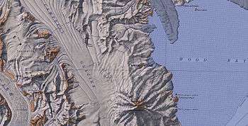
The Baker Rocks (74°14′S 164°45′E / 74.233°S 164.750°E) are a spur-like rock exposure lying 2 nautical miles (4 km) west of Wood Bay and 7 nautical miles (13 km) north of Mount Melbourne, on the coast of Victoria Land. The feature was mapped by the United States Geological Survey from surveys and from U.S. Navy air photos, 1955–63, and was named by the Advisory Committee on Antarctic Names in honor of Billy-Ace Baker, Radioman, McMurdo Station Winter-Over Party in 1963, 1967, 1971, and 1975; Summer Support Expeditions, 1976–1980.[1]
References
- ↑ "Baker Rocks". Geographic Names Information System. United States Geological Survey. Retrieved 2011-05-18.
![]() This article incorporates public domain material from the United States Geological Survey document "Baker Rocks" (content from the Geographic Names Information System).
This article incorporates public domain material from the United States Geological Survey document "Baker Rocks" (content from the Geographic Names Information System).
Coordinates: 74°14′S 164°45′E / 74.233°S 164.750°E