Bainton, East Riding of Yorkshire
| Bainton | |
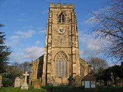 St Andrew's Church, Bainton in 2007 |
|
 Bainton |
|
| Population | 334 (2011 census)[1] |
|---|---|
| OS grid reference | SE964522 |
| – London | 170 mi (270 km) S |
| Civil parish | Bainton |
| Unitary authority | East Riding of Yorkshire |
| Ceremonial county | East Riding of Yorkshire |
| Region | Yorkshire and the Humber |
| Country | England |
| Sovereign state | United Kingdom |
| Post town | DRIFFIELD |
| Postcode district | YO25 |
| Dialling code | 01377 |
| Police | Humberside |
| Fire | Humberside |
| Ambulance | Yorkshire |
| EU Parliament | Yorkshire and the Humber |
| UK Parliament | East Yorkshire |
Coordinates: 53°57′28″N 0°31′56″W / 53.957768°N 0.532097°W
Bainton is a village and civil parish in the East Riding of Yorkshire, England. It is situated approximately 6 miles (10 km) south-west of Driffield on the A614 road.
According to the 2011 UK census, Bainton parish had a population of 334,[1] an increase on the 2001 UK census figure of 282.[2] The parish covers an area of 1,608.08 hectares (3,973.7 acres).[3]
Bainton was served by Bainton railway station on the Selby to Driffield Line between 1890 and 1954.[4]
Bainton Grade I listed Anglican church is dedicated to St Andrew.[5] Pevsner noted that the church was totally rebuilt in the 1330s or 1340s by the rector William de Brocklesby, except for the south-west corner of the chancel with its priest's doorway, which are c. 1300. Until 1715 the tower supported a spire. The font is Norman, and the pews 18th century. A tomb to Sir Edmund de Mauley lies in the south aisle; [de Mauley, Steward to Edward II, died at the Battle of Bannockburn in 1314]. The tomb has an ogee canopy, crocketed gable and flying angels holding the soul of Sir Edmund in a napkin. There is also a brass to Roger Godeale, died 1429.[6] A south porch and vestry were added by Henry Wheatley in 1843, and a restoration carried out by "Fowler of Louth" in 1866. The church's listed rectory, south of the church, is of late Georgian period. According to Pevsner a local tradition connects the rectory's coniferous garden with Paxton[6][7] The rectory's coach house and stables are also listed buildings.[8]
References
- 1 2 "Key Figures for 2011 Census: Key Statistics: Area: Bainton CP (Parish)". Neighbourhood Statistics. Office for National Statistics. Retrieved 2 February 2013.
- ↑ "2001 Census: Key Statistics: Parish Headcounts: Area: Bainton CP (Parish)". Neighbourhood Statistics. Office for National Statistics. Retrieved 14 May 2008.
- ↑ "2001 Census Area Profile" (PDF). East Riding of Yorkshire County Council. 2004. Retrieved 10 April 2013.
- ↑ Butt, R. V. J. (1995). The Directory of Railway Stations: details every public and private passenger station, halt, platform and stopping place, past and present (1st ed.). Sparkford: Patrick Stephens Ltd. ISBN 1-8526-0508-1. OCLC 60251199.
- ↑ Historic England. "Church of St Andrew (1083830)". National Heritage List for England. Retrieved 13 December 2011.
- 1 2 Pevsner, Nikolaus; The Buildings of England. Yorkshire: York and the East Riding pp. 165, 166; Penguin (1972); reprinted 1975, Pevsner Architectural Guides. ISBN 0-14-071043-4
- ↑ Historic England. "The Old Rectory (1083788)". National Heritage List for England. Retrieved 13 December 2011.
- ↑ Historic England. "Coach-house and Stables to the Old Rectory (1346477)". National Heritage List for England. Retrieved 13 December 2011.
- Gazetteer — A–Z of Towns Villages and Hamlets. East Riding of Yorkshire Council. 2006. p. 3.
External links
-
 Media related to Bainton at Wikimedia Commons
 - Bainton
- Historic England. "Details from image database (167814)". Images of England.
- Bainton in the Domesday Book