Gagarin's Start
|
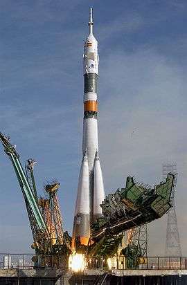
Soyuz TMA-3 is launched from Gagarin's Start | |||||||||||
| Launch site | Baikonur Cosmodrome | ||||||||||
|---|---|---|---|---|---|---|---|---|---|---|---|
| Location | 45°55′13″N 63°20′32″E / 45.920278°N 63.342222°E | ||||||||||
| Short name | LC-1/5 | ||||||||||
| Operator | Soviet space program, Russian Space Agency | ||||||||||
| Total launches | TBC | ||||||||||
| Launch pad(s) | 1 | ||||||||||
| Min / max orbital inclination | 49° – 99° | ||||||||||
| |||||||||||
Gagarin's Start[1] (Russian: Гагаринский старт, Gagarinskij start) is a launch site at Baikonur Cosmodrome in Kazakhstan, used for the Soviet space program and now managed by the Russian Federal Space Agency.
The launchpad for the world's first human spaceflight made by Yuri Gagarin on Vostok 1 in 1961, the site was referred to as Site No.1 (Площадка №1, Ploshchadka No. 1) as the first one of its kind. It is also sometimes referred to as NIIP-5 LC1, Baikonur LC1 or GIK-5 LC1.
On 17 March 1954 the Council of Ministers ordered several ministries to select a site for a proving ground to test the R-7 rocket by 1 January 1955. A special reconnaissance commission considered several possible geographic regions and selected Tyuratam in the Kazakh SSR. This selection was approved on 12 February 1955 by the Council of Ministers, with a completion of construction targeted for 1958.[2] Work on the construction of Site No.1 began on 20 July 1955 by military engineers. Day and night more than 60 powerful trucks worked at the site; 15,000 cubic metres (20,000 cu yd) of earth were excavated and removed per day, with the total volume estimated to be 750,000 cubic metres (980,000 cu yd). During winter explosives were widely utilized. By the end of October 1956 all primary building and installation of infrastructure for R-7 tests was completed. The Installation and Testing Building (Монтажно-испытательный корпус, Montazhno-ispytatel'nyj korpus) named "Site No.2" was built and a special railway completed from there to Site No.1 where the launch pad for the rocket was located.[3] By April 1957 all remaining work was completed and the site was ready for launches.
The R-7 missile made its maiden voyage from LC-1 on May 15, 1957. On 4 October 1957 the pad was used to launch the world's first artificial satellite, Sputnik 1. Manned spaceflights launched from the site include Yuri Gagarin's flight, Valentina Tereshkova's flight, and numerous other human spaceflight missions, including all Soviet and Russian manned spaceflights to Mir. The pad was also used to launch Luna program spacecraft, Mars probe program spacecraft, Venera program spacecraft, many Cosmos satellites and others.[4] From 1957 through 1966 the site hosted ready-to-launch strategic nuclear ICBMs in addition to spacecraft launches;[4] by the 2000s there were more than 400 launches from the site.[5] The 500th launch from this site was of Soyuz TMA-18M on 2 September 2015.
In 1961, the growing launch schedule of the Soviet space program resulted in the opening of a sister pad at Baikonur, LC-31/6. LC-1 has been the primary facility for manned launches, with occasional Soyuz flights from LC-31/6.
LC-1 was damaged several times by booster explosions during the early years. As of 2016, the most recent accident to occur on or around the pad was the attempted launch of Soyuz T-10-1 in September 1983 ended disastrously when the booster caught fire during prelaunch preparations and exploded, causing severe damage that left LC-1 inoperable for almost a year.
Gallery
 Soyuz TMA-16 launches from the Gagarin's Start on September 30, 2009, on its way to the International Space Station.
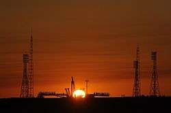 Sunrise at the launch pad prior to the rollout of Soyuz TMA-13, October 10, 2008.
 Progress M-13M launches on October 30, 2011.
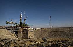 The flame trench for Gagarin's Start
See also
- Baikonur Cosmodrome Site 31
- Cape Canaveral Air Force Station Launch Complex 14, the equivalent for the United States' first manned spaceflights.
Literature
- «Korolev: Facts and myths» - J. K. Golovanov, M: Nauka, 1994, - ISBN 5-02-000822-2;
- "Rockets and people" – B. E. Chertok, M: "mechanical engineering", 1999. ISBN 5-217-02942-0 (Russian);
- «A breakthrough in space» - Konstantin Vasilyevich Gerchik, M: LLC "Veles", 1994, - ISBN 5-87955-001-X;
- "Testing of rocket and space technology - the business of my life" Events and facts - A.I. Ostashev, Korolyov, 2001.;
- "Baikonur. Korolev. Yangel." - M. I. Kuznetsk, Voronezh: IPF "Voronezh", 1997, ISBN 5-89981-117-X;
- "Look back and look ahead. Notes of a military engineer" - Rjazhsky A. A., 2004, SC. first, the publishing house of the "Heroes of the Fatherland" ISBN 5-91017-018-X.
- "Rocket and space feat Baikonur" - Vladimir Порошков, the "Patriot" publishers 2007. ISBN 5-7030-0969-3
- "Unknown Baikonur" - edited by B. I. Posysaeva, M.: "globe", 2001. ISBN 5-8155-0051-8
- "Bank of the Universe" - edited by Boltenko A. C., Kiev, 2014., publishing house "Phoenix", ISBN 978-966-136-169-9
Notes
- ↑ "As Suffredini spoke, a Soyuz TMA-5 spacecraft was being hoisted onto Russia's Baikonur launch pad, named "Gagarin's Start" after the first man in space. ", http://www.chinadaily.com.cn/english/doc/2004-10/13/content_381791.htm , China Daily, 2004-10-13 on Soyuz TMA-5 launch
- ↑ Origin of the test range in Tyuratam at Russianspaceweb.com
- ↑ (Russian) Creation and Launch of the First Earth's Satellite by V.Poroshkov Archived 29 October 2005 at the Wayback Machine.
- 1 2 Baikonur LC1
- ↑ Gagarin's pad
Coordinates: 45°55′13″N 63°20′32″E / 45.92028°N 63.34222°E
| Main articles | 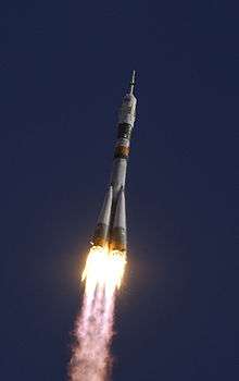 | ||||||||||||||||||||||||
|---|---|---|---|---|---|---|---|---|---|---|---|---|---|---|---|---|---|---|---|---|---|---|---|---|---|
| Rockets |
| ||||||||||||||||||||||||
| Launch sites | |||||||||||||||||||||||||
| Launches | |||||||||||||||||||||||||
| See also | |||||||||||||||||||||||||