Bahawalpur District
| Bahawalpur بہاول پور | |
|---|---|
| District | |
|
| |
| Country | Pakistan |
| Province | Punjab |
| Headquarters | Bahawalpur |
| Government | |
| • Members of National Assembly |
Syed Ali Hassan Gilani (NA-183) Najibuddin Awaisi (NA-184) Muhammad Baligh Ur Rehman (NA-185) Riaz Hussain Pirzada (NA-186) Tariq Bashir Cheema (NA-187) |
| Area | |
| • Total | 24,830 km2 (9,590 sq mi) |
| Population (1998) | |
| • Total | 2,433,091 |
| Time zone | PKT (UTC+5) |
| Number of Tehsils | 5 |
| Tehsils |
Bahawalpur Ahmedpur Sharqia Hasilpur Khairpur Tamewali Yazman |
| Languages | Saraiki, Punjabi and Urdu |

Bahawalpur District (Punjabi,Urdu: ضلع بہاول پور) is one of the districts of Punjab, Pakistan. Its capital is Bahawalpur city. According to the 1998 Census of Pakistan it had a population of 2,433,091 of which 27.01% were urban[1] Bahawalpur district covers 24,830 km². Approximately two-thirds of the district (16,000 km²) is covered by the Cholistan Desert, which extends into the Thar Desert of India. The district is a major producer of cotton.
It is located in the south of the Punjab province, Bahawalpur district is bordered by India to its south and south east, Bahawalnagar to its north east, Vehari, Lodhran and Multan to its north, Rahimyar Khan to its west and Muzaffargarh to its north west.
Administration
The district is administratively divided into five tehsils and 107 Union Councils:[2]
| Name of Tehsil | No of Unions |
|---|---|
| Ahmedpur Sharqia | 31 |
| Bahawalpur | 36 |
| Hasilpur | 14 |
| Khairpur Tamewali | 8 |
| Yazman | 18 |
| Total | 107 |
Language
Following are the demographics of the Bahwalpur district, by spoken language:
- Riasti dialects: 60%
- Standard Punjabi: 30%
- Other: 10%
Inhabitants of District speak a great variety of Riasti dialects, although few of these dialects are called as separate language “Saraiki”, but because of good and loving nature of people there is no distinction or hate among different dialects and have a mix culture of Great Bahawalpur State, Punjab and Choolistan.
- Riasti (Local state dialect spoken by 51% population which is a Mix of Rajhastani, Punjabi and Multani(Saraiki) spoken in Tehsils Bahawalpur and Ahmedpur sharqia)
- Majhi & Malwi (Standard Punjabi dialect spoken by 35% specially in majority in Tehsils Hasilpur, Yazman, Khairpur Tamiwali and sizeable population in cities)
- Bagri/Choolistani (9% Population speaks a Punjabi Rajhastani mix specially in Desert area)
- Haryanvi (1% population speaks A mixture of Punjabi and Urdu. sizeable population in cities)
Other Languages include:
- Urdu is mother tongue of few people but being national language is spoken and understood by the sizeable population.
- English is also understood and spoken by the educated elite.
- Baluchi is also spoken by small population.
History
In 711 A.D. the various parts of Punjab and whole Sindh came under the Arab rule when Muhammad Bin Qasim had conquered Sindh, Multan and surrounding areas of Shorkot. The region came securely under Umayyad Caliphate. The tribes known as Arain in the region are the decadents of those Arab soldiers who accompanied Muhammad Bin Qasim.
Sultan Mahmud Ghaznavi took over the region in 997 C.E. Ghaznavid dynasty empire established by his father, Sultan Sebuktegin, In 1005 he conquered the Shahis in Kabul in 1005, and followed it by the conquests of Punjab region. The Delhi Sultanate and later Mughal Empire ruled the region. The Punjab region became predominantly Muslim due to missionary Sufi saints whose dargahs dot the landscape of Punjab. During the period of British rule, Bahawalpur District increased in population and importance.
The district capital Bahawalpur, which lies just south of the Sutlej River, was founded in 1748 by Muhammad Bahawal Khan and was incorporated as a municipality in 1874. After the decline of the Mughal Empire, the Sikh Empire invaded some towns of modern Pakistan's Punjab province but Bahawalpur had a stronghold of the state's Abbasi nawabs in the city management and the town was free of Sikh empire. In 1836 Bahawalpur stopped paying tribute to Sikh empire, the state's army had defend the territory valiantly and openly declared independence. The founder of the State of Bahawalpur was Nawab Bahawal Khan Abbasi I. The Abbasi family ruled over the State for more than 200 years (1748 to 1954). During the rule of the last Nawab Sir Sadiq Muhammad Khan Abbasi V, Bahawalpur State was merged with Pakistan. During the 1960s (1954) the Nawab agreed (Agreement Dated 3 October 1947) for Bahawalpur to be absorbed into modern Pakistan. He was however given special privileges including the right to import several cars duty-free each year. Bahawalpur was formerly the capital of the state and now is the District and Divisional Headquarters of Bahawalpur Division.
The Nawabs of Bahawalpur originally came from Sindh and claimed descent from the Abbasid caliph of Baghdad; they formed a princely state and assumed independence in 1802.
The predominantly Muslim population supported Muslim League and Pakistan Movement. After the independence of Pakistan in 1947, the minority Hindus and Sikhs migrated to India while the Muslim refugees from India settled in the Bahawalpur District.
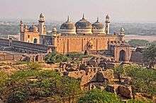
Cholistan Desert
East of Bahawalpur is the Cholistan Desert which covers an area of about 15,000 km2 and extends into the Thar Desert of India. The region was once watered by the Hakra River, known as the Saravati in vedic times. At one time there were 400 forts in the area and archaeological finds around the Derawar Fort, the only place with a perennial waterhole, indicate that it was contemporaneous with the Indus Valley Civilisation. The average annual rainfall is only 12 cm, and the little cultivation there is, is made possible by underground wells, drawn up by the camels. The water is stored in troughs, built by the tribes, between sandhills and din waterholes called tobas. The people are racially similar to those in Rajasthan - tall, with sharp features. They live in large, round, mud and grass huts, usually built on the top of sandhills. On the whole, they are pastoral and nomadic. The main tribes are the Chhachhar, Mehr, Lar, Paryar, Channar, Chandani and Bohar. The forts here were built at 29 km intervals, which probably served as guard posts for the camel caravan routes. There were three rows of these forts. the first line of forts began from Phulra and ended in Lera, the second from Rukhanpur to Islamgarh, and the third from Bilcaner to Kapoo. They are all in ruins now, and you can see that they were built with double walls of gypsum blocks and mud. Some of them date back to 1000 BC, and were destroyed and rebuilt many times.
Location
Bahawalpur is located in the southeast of Punjab province, the capital, Bahawalpur city, is 889 km from Karachi. The region surrounding Bahawalpur to the west, called the Sindh, is a fertile alluvial tract in the Sutlej River valley that is irrigated by floodwaters, planted with groves of date palms, and thickly populated. The chief crops are wheat, gram, cotton, sugarcane, and dates. Sheep and cattle are raised for export of wool and hides. East of Bahawalpur is the Pat, or Bar, a tract of land considerably higher than the adjoining valley. It is chiefly desert irrigated by the Sutlej inundation canals and yields crops of wheat, cotton, and sugarcane. Farther east, the Rohi, or Cholistan, is a barren desert tract, bounded on the north and west by the Hakra depression with mound ruins of old settlements along its high banks; it is still inhabited by nomads. The principal inhabitants of the region surrounding Bahawalpur are Arain, Jat and Baluchi peoples. There are many historical sites in the area, including Uch, southwest of Bahawalpur, an ancient town dating from Indo-Scythian (Yüeh-chih) settlement (c. 128 BC to AD 450). Pop. (1981) City, 180,263; (1981 prelim.) metropolitan area, 695,000.
Bahawalpur is also an important agricultural training and educational center. Soapmaking and cotton ginning are important enterprises; cotton, silk, embroidery, carpets, and extraordinarily delicate pottery are produced. Factories producing cottonseed oil and cottonseed cake were built in the 1970s. It is an important marketing centre for the surrounding areas and is located on the crossroads between Peshawar, Lahore, Quetta and Karachi. Bahawalpur is also known for its distinctly embroidered slippers and shoes and the filigree pottery which is made here.
The City is located favourably for commerce, lying at the junction of trade routes from the east, south-east, and south. It is a centre for trade in wheat, cotton, millet, and rice grown in the surrounding region. Dates and mangoes are also grown here. Canals supply water for irrigation. The principal industries are cotton ginning, rice and flour milling, and the handweaving of textiles.
Oldest Ghalla Mandi is located in the Yazman Mandi tehsil.
References
Neighbourhoods of Bahawalpur | ||
|---|---|---|
Administrations: Bahawalpur Division and Bahawalpur District | ||
| Tehsils |  | |
| Cities | ||
| Towns and councils | ||
| Villages | ||
Website: Bahawalpur District at NRB | ||
Provincial capital: Lahore | ||
| Bahawalpur | _Districts.svg.png) | |
| Dera Ghazi Khan | ||
| Faisalabad | ||
| Gujranwala | ||
| Lahore | ||
| Multan | ||
| Rawalpindi | ||
| Sargodha | ||
| Sahiwal | ||
| Sheikhupura | ||
See also: Districts of Punjab, India | ||
Coordinates: 28°50′N 71°40′E / 28.833°N 71.667°E