Baharampur
- For the settlement in Bangladesh, see Baharampur, Bangladesh.
| Baharampur বহরমপুর Berhampore | ||||||||
|---|---|---|---|---|---|---|---|---|
| City / Urban Agglomeration | ||||||||
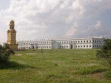
Berhampore montage | ||||||||
 Baharampur Location in West Bengal, India | ||||||||
| Coordinates: 24°06′N 88°15′E / 24.1°N 88.25°ECoordinates: 24°06′N 88°15′E / 24.1°N 88.25°E | ||||||||
| Country |
| |||||||
| State | West Bengal | |||||||
| District | Murshidabad | |||||||
| Area rank | 5th | |||||||
| Elevation | 18 m (59 ft) | |||||||
| Population (2011) | ||||||||
| • Total | 305,609 | |||||||
| Languages | ||||||||
| • Official | Bengali, English | |||||||
| Time zone | IST (UTC+5:30) | |||||||
| PIN | 742101, 742102, 742103 | |||||||
| Telephone code | 91-3482-2xxxxx | |||||||
| Vehicle registration | WB57, WB58 | |||||||
| Lok Sabha constituency | Murshidabad | |||||||
| Vidhan Sabha constituency | Murshidabd | |||||||
| Website |
berhamporemunicipality | |||||||


Baharampur (Pronounced asˌbɑ:(h)ərəmˌpʊə) is a city in the state of West Bengal, India. As of the 2011 census,[1] it was the seventh largest city in West Bengal (after Kolkata, Asansol, Siliguri, Durgapur, Barddhaman and English Bazar) and is situated in the central part of West Bengal. In 2011, Baharampur was nominated to become a municipal corporation. In earlier days it was known as Brahmapur because many of the Brahmin families settled here. Baharampur is the administrative headquarters of the Murshidabad district. It is located about 200 km (124 mi) from Kolkata, the state capital.
History

Berhampore was fortified in 1757 by the East India Company, after the Battle of Plassey in June 1757, and it continued as a cantonment until 1870. But the foundation of the city of Berhampore remains questionable.
Karnasubarna, which is very near to Berhampore, has a history dating back to 600 AD. Many buildings from the late 1600s can still be seen. The cantonment was constituted as a municipality in 1876 and was the headquarters of Murshidabad district. The Berhampore College was founded in 1853 and in 1888 made over to a local committee, mainly supported by Rani Swarnamayi.
On 25 February 1857, the first major armed battle of the Sepoy Mutiny of 1857 took place in Barrack Square, Baharampur,[2] while Berhampore was ruled by Raja Krishnath and his ancestors. In 1901, Baharampur had a population of 24,397, and included the ancient town of Kasim Bazar.[3] The place which is considered as a legitimate arena of all procedural events and circumstances that has been profoundly well described. Both Cossim Bazar and Lalbagh boar testimony to a blood-spattered yet majestic epoch in Indian history.
A very much impacted area of Berhampore are those places in the banks of the stream Bhagirathi river giving a receding process of downgrade and evolution of the abscess marketing and thus leading to one of the well victimised estate of remarkable famine conditions prevailed in 1971. This area was and still is a splendid producer of jute and it defines how the cultivation of the land is in this region. In those days sons learnt from their fathers that the fields near the stream of the Ganges are the most fertile land, so this was described by the British as "The Golden Bengal".
Down the time after the East India Company, there happens to be a lot of disruption in the Law and Order of the place. It is not balanced properly, it may be due to the unprecedented activities and thus making a black mark on the soil, which once used to be called as the capital of the country. Yes it the obvious reason Murshidabad was considered to be called the capital, then it was directed to Calcutta (now Kolkata) be the capital and thus finally it was accepted as Delhi.
One of the most enthralling and sedimentary arena is the SQUARE field, nearby this square field is the Collectors office, SDO office. The renowned Government College of Engineering & Textile Technology beside the arena provides an appealing yard. The SQUARE field is a life line for most of the persons aspiring their career in Indian Armed forces. Every year hundreds of young do take part in the recruitment process. Some find themselves fit into the box and some are left with other options waiting for them. This field is always crowded with lots of people such as youth practising sports and many other cultural activities does take place here. This place is spiritually poured with lots of love and feelings of persons, most of the retired personnel comes back to this arena where they once toiled their days to get in the rank to serve the GREAT NATION INDIA.
Geography
Baharampur is located at 24°06′N 88°15′E / 24.1°N 88.25°E.[4] It has an average elevation of 18 metres (59 feet).
The city is located approximately 200 km north of Kolkata at 24°4′N 88°9′E / 24.067°N 88.150°E and is situated on the eastern side of the Bhagirathi River, a major distributary of the Ganges.
Demographics
In the 2011 census, Baharampur Urban Agglomeration had a population of 305,609, out of which 156,489 were males and 149,120 were females. The 0–6 years population was 23,182. Effective literacy rate for the 7+ population was 88.38.[1]
As of 2001 Indian census,[5] Baharampur had a population of 160,168. Males constitute 51% of the population and females 49%. Baharampur has an average literacy rate of 79%, higher than the national average of 59.5%; with 53% of the males and 47% of females literate. 9% of the population is under 6 years of age.
Economics
Initially, most of the residents of this city were government employees and there were few agricultural as well as silk traders. Gradually, the importance of the city increased due to its geographic location and now it is also a business hub. Due to its historical importance, this city also earns a good number of tourists, thus making tourism another happening industry there.
Khagras major industries include agricultural related industries like rice and oil-seed milling etc. Home-crafts like silk weaving, ivory carving, and precious metal working is another important industry in this city. Khagra, a neighbourhood in Bahrampur is renowned for its manufacture of bell-metal and brass utensils, as well as ivory, and wood carving.[6][7] A famous type of metal used to make bells called "Khagrai Kansha" is made in the city. This is a type of brass that is used to make utensils like dishes & bowls.
The city has many big shops which now have become the prime shopping destinations. Express Bazaar, situated at the Mohana Bus Stand- the prime junction of the city is one of them. Style Baazar, Manmohini, Sunita, Metro Bazar are some famous shops at Khagra- another prime market area of the city.
The only "Inox" of the town is Silverscreen multiplex which is located near Berhampore Court railway station. Tickets of this multiplex are available from bookmyshow.com.
Baharampur is famous for the sweet 'Chhana-bora', the savoury 'Khaja', sweet 'Manohara' and also very famous for Murshidabad Silk (Tassar).
Kalika which is being used in most of the Sweet shops, Goldsmiths shops and many other small scale industries. The name Kalika is the Goddess 'Kali', which does cause an impact of resonance to mankind feelings. It refreshes the thoughts and does purify the air around the despair environment.
Arts
Having patronage from the nawabs, artists from various field of arts sowed the seed of cultural heritage in this place. The calm lifestyle of this city still evokes a rich cultural environment. Almost all well-to-do parents send their kids to at least one school of art. Among them, dancing, acting, painting, music etc. are the most popular. Several elegant pieces of hand-craft arts can also be found in this region, namely the handcraft in making of carpet, bamboo and jute crafts, miniature paintings.
Education
Among the government aided schools, Krishnath College School. Private schools include Mary Immaculate School. Prabharani, Gitaram Institution. Under the central government lies Kendriya Vidyalaya. Colleges are Krishnath College, Berhampore College, Berhampore Girls' College, Murshidabad College of Engineering & Technology, Government College of Engineering & Textile Technology, Berhampore, Murshidabad Medical College, Central Sericulture Research and Training Institute, administrated by Central Silk board, Govt. of India is a notable research institute in the city.
Transport
Rail - Berhampore Court railway station (BPC), Cossimbazar Station (CSZ) stands on the Sealdah-Lalgola line of the eastern railway.Main trains are Bhagirathi express(13103/13104), Hazarduari express(13113/13114), Dhanodhanya express(13117/13118). Other passenger trains include Sealdah-Lalgola passenger, Sealdah-Berhampore Court Memu passenger, Ranaghat jn-Lalgola Memu passengers. Khagraghat Road (KGLE) station stands on the Howrah-Azimganj jn line of the eastern railway. Main trains of this line are Sealdah-New Alipurduar Teesta-Torsa express, Howrah-Dibrugarh Kamrup Express, Kolkata-Radhikapur express, Hatey Bazare express, Howrah-Malda Town Intercity express, Puri-Kamakhya express via Howrah, Digha-New Jalpaiguri Paharia express, Nabadwip Dham-Malda Town express etc.
Road - as Baharampur is the administrative headquarters of the Murshidabad district and as it stands just in the centre position of West Bengal, it acts as the link between North Bengal and South Bengal. This city is well connected by National Highway 34. The local transportation dependent on rickshaws and E-rickshaws (known as tuk-tuk or toto car). There are bus services on regular basis from South Bengal to North Bengal and vice versa and there is a Bus Terminus called 'Mohona'.There are regular bus services to Kolkata (Espalande). Bus services are also available to other parts of West Bengal such as Durgapur, Siuri, Asansol, Burdwan, Bankura, Jhargram, Bolpur, Rampurhat, Nalhati, Kirnahar, Malda, Siliguri, Balurghat, Gangarampur, Krishnanagar, Ranaghat, Saintha. Bus service is also available to Dumka (Jharkhand).
Water - as Berhampore is city just beside the river Bhagirathi, for water transport.. Berhampore north to Berhampore south is connected via launchboats. Regular boat transport is also available from Berhampore to other towns of Murshidabad such as Azimganj and Jiaganj.
Tourist spots


Baharampur is a famous place for tourists in West Bengal. It gets tourists' flow from locals as well as from foreigners, being the first headquarters of the East India Company and having a long history enriched by the Nawabs of Bengal, Sultans of Bengal, Zamindar and other European colonial forces such as Dutch, Portuguese, English (British Raj) and French.
Some notable tourist destinations in and around Baharampur are:
- Krishnath College
- Nashipur Palace
- Home of Jagat Seth
- Jafarganj Cemetery
- Kathgola Palace
- Fauti Masjid
- Khushbagh
Legacy
The city of Berhampore also shares its name with Berhampore at Wellington, New Zealand. The daughter of Major Paul married local land owner George Hunter. Major Paul was an Indian army officer. George Hunter to show respect to his father in law gave Berhampore the name of the suburb. The old house of the "De" family (relatives of the Cossimbazar Raj) at Churamani Chowdhury Lane is also one of the oldest buildings in Berhampore and was at one point of time the property of the Cossimbazar Raj.
Notable people from Berhampore
- Arup Chandra, Poet, Writer
- Mahasweta Devi (born 1926), daughter of poet Manish Ghatak, writes short stories and novels.
- Moniruddin Khan, Writer, Historian
- Ramendra Sundar Tribedi, Writer
- Rakhaldas Bandyopadhyay, Historian
- Tridib Chaudhuri, Politician
- Micaiah John Muller Hill, British Mathematician.
- Sir George Francis Hill, Director and Principal Librarian of the British Museum (1931–1936).
- Nabarun Bhattacharya, Writer
- Mir Afsar Ali, Radio Jockey, Television Anchor, News Anchor, Singer, Comedian & Actor
- Arijit Singh, Playback Singer & Music programmer
- Shreya Ghoshal, Singer[8]
- Sudip Roy, Artist
References
- 1 2 "Urban Agglomerations/Cities having population 1 lakh and above" (PDF). Provisional Population Totals, Census of India 2011. Retrieved 21 October 2011.
- ↑
 Chisholm, Hugh, ed. (1911). "Berhampur (Bengal)". Encyclopædia Britannica (11th ed.). Cambridge University Press..
 - ↑ Chisholm, Hugh, ed. (1911). "Cossimbazar". Encyclopædia Britannica (11th ed.). Cambridge University Press..
- ↑ Falling Rain Genomics, Inc - Baharampur
- ↑ "Census of India 2001: Data from the 2001 Census, including cities, villages and towns (Provisional)". Census Commission of India. Archived from the original on 16 June 2004. Retrieved 1 November 2008.
- ↑ "Handicrafts and silk industry". Murshidabad district administration. Retrieved 8 September 2007.
- ↑ "Crafts and artisans of India". craftandartisans.com. Archived from the original on 11 September 2007. Retrieved 8 September 2007.
- ↑ http://www.shreyaghoshal.com/Biography.aspx?id=$
Sources
External links
| Wikimedia Commons has media related to Baharampur. |
- Map of Murshidabad district on CalcuttaWeb.Com
- Latitude and Longitude locations maps in India
- City populations in West Bengal
-
 Baharampur travel guide from Wikivoyage
Cities, towns and locations in Murshidabad District | |||||||||||||||||||
|---|---|---|---|---|---|---|---|---|---|---|---|---|---|---|---|---|---|---|---|
| Cities, municipal and census towns |
| ||||||||||||||||||
| Locations other than cities and towns | |||||||||||||||||||
| Related topics |
| ||||||||||||||||||