Bagerhat Sadar Upazila
| Bagerhat বাগেরহাট | |
|---|---|
| Upazila | |
|
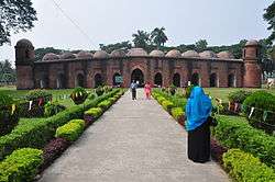
The Sixty Dome Mosque in Bagerhat | |
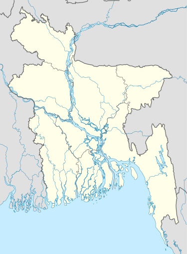 Bagerhat Location in Bangladesh | |
| Coordinates: 22°39.8′N 89°47.5′E / 22.6633°N 89.7917°ECoordinates: 22°39.8′N 89°47.5′E / 22.6633°N 89.7917°E | |
| Country |
|
| Division | Khulna Division |
| District | Bagerhat District |
| Area | |
| • Total | 272.73 km2 (105.30 sq mi) |
| Population (2011) | |
| • Total | 266.389 |
| • Density | 865/km2 (2,240/sq mi) |
| Time zone | BST (UTC+6) |
| Website | Official Map of Bagerhat Sadar |
Bagerhat Sadar (Bengali: বাগেরহাট সদর) is an Upazila of Bagerhat District in the Division of Khulna, Bangladesh.[1] The municipality was established in 1958. It consists of 9 wards and 31 mahallas.
History
Khan Jahan Ali established a pargana named Khalifatabad here in 1429 AD, which covered Bagerhat, Khulna, Jessore, Satkhira and Barisal. The Sixty Dome Mosque was the central administrative place of the kingdom. He built a mint, several mosques, and excavated several lakes.
During the Bangladesh Liberation War, Razakar Seraj Master killed 18 members of a family in the area. Battles between the Pakistan army and the Bangladeshi Freedom Fighters, the Mukti Bahini, were held at Panighat, Devir Bazar and Madhav Kathi.
Geography
Bagerhat Sadar has 45,527 households and a total area of 272.73 km². Bagerhat Sadar Upazila is bounded by Fakirhat and Chitalmari upazilas on the north, Morrelganj upazila on the south, Kachua upazila on the east, Rampal and Fakirhat upazila on the west. The main rivers in the area are the Bhairab, Chitra, Daudkhali, Poylahar, and the Putimari.
Demographics
As of the 1991 Bangladesh census, Bagerhat Sadar has a population of 235,848. Bagerhat Sadar has an average literacy rate of 49.9% (7+ years), compared to the Bangladeshi national average of 32.4%.[2]
Economy
Health organization
In Bagerhat Sadar, there is 1 government hospital, 2 satellite clinics, 10 union health and family planning centers, 1 maternity clinic, 7 private clinics, and 2 nursing training schools.
Main crops
Paddy, wheat, jute, potato, banana and papaya, garlic, onion are the main crops of Bagerhat Sadar.
Industry
Bagerhat Sadar had 28 spice grinding mills, 22 flour mills, 25 rice mills, and 28 coconut oil mill. Cottage industries include 70 goldsmiths, 40 blacksmiths, 60 welders, 1 honey cultivation project, and 1 bidi factory.
Arts and Culture
The Mosque City of Bagerhat, a UNESCO-registered complex of Muslim architecture, is in the suburbs of Bagerhat city. Apart from the mosque recently Khan Jahan Ali's home has been dug out. Concerning modern culture, there are 4 public libraries, 1 museum, 2 cinemas, 25 rural clubs, 1 women's organization, and 1 playground in Bagerhat Sadar Upazila.
Administration
Bagerhat Sadar has 10 Wards/Unions, 187 Mauzas/Mahallas, and 167 villages.
The current UP chairman is Khan Habibur Rahman who was voted to this post for the 2nd consecutive time in January 2012.
See also
References
- ↑ HM Khaled Kamal (2012), "Bagerhat Sadar Upazila", in Sirajul Islam and Ahmed A. Jamal, Banglapedia: National Encyclopedia of Bangladesh (Second ed.), Asiatic Society of Bangladesh
- ↑ "Population Census Wing, BBS.". Archived from the original on 2005-03-27. Retrieved November 10, 2006.
External links
| Wikivoyage has a travel guide for Bagerhat. |
| Upazila/Thana: | ||
|---|---|---|