Badia, South Tyrol
| Badia | ||
|---|---|---|
| Comune | ||
| Comun de Badia Comune di Badia Gemeinde Abtei | ||
|
Badia (Abtei) | ||
| ||
 Badia Location of Badia in Italy | ||
| Coordinates: 46°35′N 11°54′E / 46.583°N 11.900°ECoordinates: 46°35′N 11°54′E / 46.583°N 11.900°E | ||
| Country | Italy | |
| Region | Trentino-Alto Adige/Südtirol | |
| Province / Metropolitan city | South Tyrol (BZ) | |
| Frazioni | La Ila (La Villa, Stern), San Ciascian (San Cassiano, Sankt Kassian) | |
| Government | ||
| • Mayor | Giacomo Frenademetz | |
| Area | ||
| • Total | 82 km2 (32 sq mi) | |
| Elevation | 1,315 m (4,314 ft) | |
| Population (Nov. 2010) | ||
| • Total | 3,356 | |
| • Density | 41/km2 (110/sq mi) | |
| Demonym(s) | Badioć, Badiotti, Abteier | |
| Time zone | CET (UTC+1) | |
| • Summer (DST) | CEST (UTC+2) | |
| Postal code | 39036 | |
| Dialing code | 0471 | |
| Patron saint | Saint Leonard | |
| Website | Official website | |


Badia (Italian pronunciation: [baˈdiːa]; German: Abtei [abˈtaɪ̯]) is a comune (municipality) in South Tyrol, northern Italy. It is one of the five Ladin-speaking communities of the Val Badia.
Geography
Neighboring municipalities
The following communities neighbor Badia: Cortina d'Ampezzo, Corvara, Mareo, Livinallongo del Col di Lana, San Martin de Tor, La Val and Sëlva.
Frazioni
The municipality of Badia contains the frazioni (subdivisions, mainly villages and hamlets) La Ila (La Villa, Stern), San Ciascian (San Cassiano, St. Kassian) and the town of Badia itself.

History
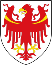
Coat of arms
The emblem is that of the Winkler Colz von zu Rubatsch family which, in the 16th and 17th century, had property and the castle at La Ila. The shield is party per fess, at the top is represented a sable steinbock, holding with the front hoofs a red broken branch on an or background. The lower part is divided into three, with vertex at the top, alternating gules and argent with a rose in the center; every rose has the central petal in or. The emblem was granted in 1967.[1]
Society
Linguistic distribution
According to the 2011 census, 94.07% of the population speak Ladin, 4.17% Italian and 1.76% German as first language.[2]
|
Main sights
Natural areas
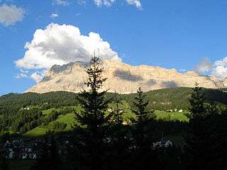
Badia is part of the Puez-Geisler and the Fanes-Sennes-Prags Nature Park. It is also near the mountains of Lagazuoi (2,778 m), Conturines (3,064 m), La Varela (3,055 m), L'Ciaval (Kreuzkofel) (2,907 m) and Gardenaccia (2,500 m).
A pilgrimage church, the Church of the Holy Cross, is located near the birthplace of Saint Josef Freinademetz.
Culture
Notable people
- Micurà de Rü (1789–1847), born in Rü, San Cascian, Ladin linguist.
- Joseph Freinademetz (1852–1908), born in Oies, Catholic saint and missionary to China.
Economy
As in other Ladin-speaking communities in South Tyrol, tourism is the most important contributor to Badia's economy. Around 69% of the population work in the service sector, around 21% work in production, and around 10% work in agriculture, however most of these hold other jobs as well and farm on the side.
Part of the comune lies in Alta Badia, a ski resort at the top end of the Val Badia valley, surrounded by the peaks of the Dolomites mountains.
Transport
Badia is accessible through the Val Badia from St. Lorenzen in the Puster Valley, as well as through passes over the Dolomites such as the Valparola Pass and the Gardena Pass, which are only drivable during the snow-free months.
Sport
Maratona dles Dolomites

The start of the annual single-day seven mountain passes crossing Maratona dles Dolomites bicycle race is every year in La Ila.
References
- ↑ Heraldry of the World: Abtei
- 1 2 "Volkszählung 2011/Censimento della popolazione 2011". astat info. Provincial Statistics Institute of the Autonomous Province of South Tyrol (38): 6–7. June 2012. Retrieved 2012-06-14.
- ↑ Oscar Benvenuto (ed.): "South Tyrol in Figures 2008", Provincial Statistics Institute of the Autonomous Province of South Tyrol, Bozen/Bolzano 2007, p. 16, table 10
External links
- (Ladin) (Italian) (German) Homepage of the municipality
![]() Media related to Badia, South Tyrol at Wikimedia Commons
Media related to Badia, South Tyrol at Wikimedia Commons