Babeau-Bouldoux
| Babeau-Bouldoux | |
|---|---|
|
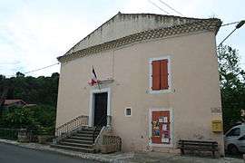
The town hall in Babeau-Bouldoux | |
 Babeau-Bouldoux | |
|
Location within Occitanie region  Babeau-Bouldoux | |
| Coordinates: 43°26′13″N 2°54′36″E / 43.4369°N 2.91°ECoordinates: 43°26′13″N 2°54′36″E / 43.4369°N 2.91°E | |
| Country | France |
| Region | Occitanie |
| Department | Hérault |
| Arrondissement | Béziers |
| Canton | Saint-Chinian |
| Intercommunality | Saint-Chinianais |
| Government | |
| • Mayor (2008–2014) | Jean-Louis Bousquet |
| Area1 | 21.4 km2 (8.3 sq mi) |
| Population (2008)2 | 296 |
| • Density | 14/km2 (36/sq mi) |
| Time zone | CET (UTC+1) |
| • Summer (DST) | CEST (UTC+2) |
| INSEE/Postal code | 34021 / 34360 |
| Elevation |
153–681 m (502–2,234 ft) (avg. 200 m or 660 ft) |
|
1 French Land Register data, which excludes lakes, ponds, glaciers > 1 km² (0.386 sq mi or 247 acres) and river estuaries. 2 Population without double counting: residents of multiple communes (e.g., students and military personnel) only counted once. | |
Babeau-Bouldoux (Babau e Boldors in Occitan) is a commune in the Hérault department in the Occitanie region in southern France.

Map
Population
| Historical population | ||
|---|---|---|
| Year | Pop. | ±% |
| 1962 | 296 | — |
| 1968 | 321 | +8.4% |
| 1975 | 242 | −24.6% |
| 1982 | 249 | +2.9% |
| 1990 | 249 | +0.0% |
| 1999 | 243 | −2.4% |
| 2008 | 296 | +21.8% |
See also
References
| Wikimedia Commons has media related to Babeau-Bouldoux. |
This article is issued from Wikipedia - version of the 11/12/2016. The text is available under the Creative Commons Attribution/Share Alike but additional terms may apply for the media files.