BR-453
| |
|---|---|
| Rota do Sol | |
 | |
| Route information | |
| Length: | 201.76 mi[1] (324.70 km) |
| Existed: | 1972 – present |
| Major junctions | |
| West end: | Venâncio Aires, Rio Grande do Sul |
|
| |
| East end: | Terra de Areia, Rio Grande do Sul |
| Highway system | |
|
Highways in Brazil | |

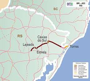
BR-453, also called the Rota do Sol (Route of the Sun) is a Brazilian Federal Highway with a length of approximately 202 miles (325 km) that links the east coast of Rio Grande do Sul to the Serra Gaúcha (Gaucho mountain range). The highway starts in Venâncio Aires and ends in Terra de Areia in the southern Brazilian state of Rio Grande do Sul.
Work on the highway was started in 1972 and completed in 2008. BR-453 functions as a shortcut to the beaches of Rio Grande do Sul shaving off 100 km (62 mi) from the old route.[2] Before the construction of BR-453, all transit going from the Gaucho Range to the coast had to drive through the capital city of Porto Alegre and go along BR-290 (referred to as "Freeway" in Portuguese).
References
- ↑ "BR-453 length between major junctions". Ministério dos Transportes do Brasil. Archived from the original on November 22, 2012. Retrieved August 21, 2014.
- ↑ "Venha à Serra Gaúcha pela Rota do Sol" (in Portuguese). GramadoSite.com. March 3, 2008. Retrieved August 21, 2014.
O novo cartão postal gaúcho reduziu em mais de 100km o trajeto entre a Serra e Litoral...
See also
| Rodovias radiais | |
|---|---|
| Rodovias longitudinais | |
| Rodovias transversais |
|
| Rodovias diagonais | |
| Rodovias de ligação |
|
This article is issued from Wikipedia - version of the 10/23/2016. The text is available under the Creative Commons Attribution/Share Alike but additional terms may apply for the media files.