Azalea Park, Florida
| Azalea Park, Florida | |
|---|---|
| Census-designated place | |
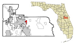 Location in Orange County and the state of Florida | |
| Coordinates: 28°32′30″N 81°17′47″W / 28.54167°N 81.29639°WCoordinates: 28°32′30″N 81°17′47″W / 28.54167°N 81.29639°W | |
| Country |
|
| State |
|
| County | Orange |
| Area | |
| • Total | 3.2 sq mi (8.4 km2) |
| • Land | 3.2 sq mi (8.3 km2) |
| • Water | 0.04 sq mi (0.1 km2) |
| Elevation | 95 ft (29 m) |
| Population (2010) | |
| • Total | 12,556 |
| • Density | 3,900/sq mi (1,500/km2) |
| Time zone | Eastern (EST) (UTC-5) |
| • Summer (DST) | EDT (UTC-4) |
| ZIP code | 32807 |
| Area code(s) | 407 |
| FIPS code | 12-02850[1] |
| GNIS feature ID | 0278014[2] |
Azalea Park is a census-designated place and an unincorporated area in Orange County, Florida, United States. The population was 12,556 at the 2010 census.[3] It is part of the Orlando–Kissimmee–Sanford, Florida Metropolitan Statistical Area.
Geography
Azalea Park is located at 28°32′30″N 81°17′47″W / 28.541546°N 81.296372°W (28.541546, -81.296372).[4]
According to the United States Census Bureau, the CDP has a total area of 8.4 km2 (3.2 mi2). 8.3 km2 (3.2 mi2) of it is land and 0.1 km2 (0.04 mi2) of it (0.93%) is water.
It is bordered by Colonial Drive (State Road 50) to the north, Goldenrod Road (State Road 551) to the east, and Curry Ford Road (State Road 552) to the south. The western boundary varies: when south of Lake Underhill Road, the western boundary is Semoran Boulevard (State Road 436), but when north of Lake Underhill Road the western boundary is the Orlando Executive Airport (ORL) and Lake Barton.
Demographics
| Historical population | |||
|---|---|---|---|
| Census | Pop. | %± | |
| 1970 | 7,367 | — | |
| 1980 | 8,301 | 12.7% | |
| 1990 | 8,926 | 7.5% | |
| 2000 | 11,073 | 24.1% | |
| 2010 | 12,556 | 13.4% | |
| source:[3][5] | |||
As of the census[1] of 2000, there were 11,073 people, 3,981 households, and 2,695 families residing in the CDP. The population density was 1,331.9/km2 (3,450.1/mi2). There were 4,115 housing units at an average density of 495.0/km2 (1,282.1/mi2). The racial makeup of the CDP was 70.23% White, 6.75% African American, 0.50% Native American, 3.60% Asian, 0.07% Pacific Islander, 14.55% from other races, and 4.30% from two or more races. Hispanic or Latino of any race were 38.97% of the population.
There were 3,981 households out of which 33.8% had children under the age of 18 living with them, 45.1% were married couples living together, 16.3% had a female householder with no husband present, and 32.3% were non-families. 21.6% of all households were made up of individuals and 5.8% had someone living alone who was 65 years of age or older. The average household size was 2.77 and the average family size was 3.26.
In the CDP the population was spread out with 25.8% under the age of 18, 13.5% from 18 to 24, 32.8% from 25 to 44, 17.6% from 45 to 64, and 10.3% who were 65 years of age or older. The median age was 31 years. For every 100 females there were 97.2 males. For every 100 females age 18 and over, there were 94.4 males.
The median income for a household in the CDP was $32,841, and the median income for a family was $40,057. Males had a median income of $26,385 versus $21,445 for females. The per capita income for the CDP was $14,136. About 8.9% of families and 11.5% of the population were below the poverty line, including 12.6% of those under age 18 and 8.4% of those age 65 or over.
Services
Government services
Azalea Park is served by the Orange County government. Police service includes the Orange County Sheriff's Office and the Florida Highway Patrol. Fire/EMS service is provided through Orange County Fire Rescue. Rural-Metro also provides EMS service in the area. The Florida Highway Patrol has its Orlando station just off of Semoran Blvd (State Road 436) and Lake Underhill Rd.
The Florida Highway Patrol, Florida Fish and Wildlife Conservation Commission, Orange County Fire Rescue have their communications centers in Azalea Park. Both Orange County and the city of Orlando have their Emergency Operations Centers in the area. The Florida Department of Transportation, has an office in Azalea Park in the same building with the Florida Highway Patrol. This office houses construction offices as well as the Orlando RTMC.
Azalea Park is served by the Greater Orlando Aviation Authority with two airports. Orlando International Airport (MCO) to the south and Orlando Executive Airport (ORL) to the immediate western boundary.
Hospitals
The primary hospital in the area is Florida Hospital East owned and operated by Adventist Health System. However, Orlando Regional Medical Center is less than three miles away and has Central Florida's only Level 1 Trauma Center.
Schools
Schools within the neighborhood include Azalea Park Elementary School, Azalea Park Baptist School, Chickasaw Elementary School, Forsyth Woods Elementary School and Colonial High School. These schools have received average grades from the state in previous years.
Full Sail University is located just outside the physical boundaries.
Valencia Community College East is the closest public post-secondary institution to Azalea Park.
Taxes, politics/government, utilities
Property taxes in the area are set by the Orange County Property Appraiser. The current 2010 mill rate was 4.4347. The sales tax is 6.5% and there is no state income tax.
It is Florida's 8th Congressional District currently served by Republican Daniel Webster in the United States House of Representatives. The State is served by Senators Bill Nelson (D) and Marco Rubio (R).
The area is governed by Orange County, led by Orange County Board of County Commissioners which is headed by Mayor Teresa Jacobs.
Utilities in the area are provided by Orlando Utilities Commission on the northwest side of the community (north of Lake Underhill Rd. and west of Forsyth Rd. The areas south of Lake Underhill Rd. but north of Curry Ford Rd. and north of Lake Underhill Rd and east of Forsyth Rd are handled by Orange County Utilities (water and solid waste) and Florida Power & Light or Progress Energy Inc.
References
- 1 2 "American FactFinder". United States Census Bureau. Archived from the original on 2013-09-11. Retrieved 2008-01-31.
- ↑ "US Board on Geographic Names". United States Geological Survey. 2007-10-25. Retrieved 2008-01-31.
- 1 2 "Profile of General Population and Housing Characteristics: 2010 Demographic Profile Data (DP-1): Azalea Park CDP, Florida". U.S. Census Bureau, American Factfinder. Archived from the original on September 11, 2013. Retrieved September 21, 2012.
- ↑ "US Gazetteer files: 2010, 2000, and 1990". United States Census Bureau. 2011-02-12. Retrieved 2011-04-23.
- ↑ "CENSUS OF POPULATION AND HOUSING (1790-2000)". U.S. Census Bureau. Archived from the original on July 8, 2010. Retrieved 2010-07-17.
External links
Municipalities and communities of Orange County, Florida, United States | ||
|---|---|---|
| Cities |  | |
| Towns | ||
| CDPs |
| |
| Unincorporated communities | ||
| Footnotes | ‡This populated place also has portions in an adjacent county or counties | |
| Attractions |
|  |
|---|---|---|
| Colleges and universities | ||
| Media |
| |
| Airports | ||
| Counties | ||
| Cities and towns 25k+ | ||
| Cities and towns 10k–25k | ||
‡ This populated place is included in the Orlando–Deltona–Daytona Beach, FL Combined Statistical Area. See also: | ||