Awash River
| Lower Valley of the Awash | |
|---|---|
| Name as inscribed on the World Heritage List | |
 | |
| Type | Cultural |
| Criteria | ii, iii, iv |
| Reference |
[whc |
| UNESCO region | Africa |
| Inscription history | |
| Inscription | 1980 (4th Session) |
The Awash (sometimes spelled Hawash; Afar We'ayot), Somali: Webiga Dir, is a major river of Ethiopia. Its course is entirely contained within the boundaries of Ethiopia, and empties into a chain of interconnected lakes that begin with Lake Gargori and end with Lake Abbe (or Abhe Bad) on the border with Djibouti, some 100 kilometers (60 or 70 miles) from the head of the Gulf of Tadjoura. It is the principal stream of an endorheic drainage basin covering parts of the Amhara, Oromia and Somali Regions, as well as the southern half of the Afar Region. According to Huntingford, in the 16th century the Awash river was called the great Dir river and lay in the country of the Muslims. [1]
Overview

The Awash rises south of Mount Warqe, west of Addis Ababa in the woreda of Dandi, close to the town of Ginchi, West Shewa Zone, Oromia. Then, the Awash flows south to loop around Mount Zuqualla in an easterly then northeasterly direction, passing the Awash National Park. It is then joined on its left bank by its chief affluent, the Germama (or Kasam) River, before turning northeast at approximately 11° N 40° 30' E as far north as 12° before turning completely east to reach lake Gargori.
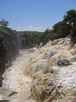
According to materials published by the Ethiopian Central Statistical Agency, the Awash River is 1200 kilometers long.[2] The author of the 1911 Encyclopædia Britannica article describes its middle portion as "a copious stream nearly 200 feet [60 meters] wide and 4 feet [1.2 meters] deep in the dry season, and during the floods rising 50 or 60 feet [15 to 20 meters] above low-water mark, thus inundating the plains for many miles along both its banks."[3]
Other tributaries of the Awash include (in order upstream): the Logiya, Mille, Borkana, Ataye, Hawadi, Kabenna and Durkham Rivers. Towns and cities along its course include Metehara, Awash, Gewane and Asaita.
History
.JPG)
Humans have lived in the valley of the Awash almost since the beginning of the species. The Middle Awash has been where numerous pre-human hominid remains have been found.[4]
The valley of the Awash from about 9° N downstream is the traditional home of the Afar people. The valley of the Awash have been included as part of the territories of the historic provinces or kingdoms of Dawaro, Fatagar, Ifat, and Shewa.[5] Except for Shewa, these provinces disappeared with the arrival of groups of the Oromo in the 16th century.

The first European to trace the course of the Awash to its end in the Aussa oasis was Wilfred Thesiger in 1933/1934, who started at the city of Awash, followed the river's course to its final end in Lake Abhebad, and continued his expedition east to Tadjoura. (Although the explorer L.M. Nesbitt had followed parts of the course of the Awash in 1928, he turned away from the river at Asaita and proceeded north through the Afar Depression to the Red Sea.[6])
In 1960, the Koka Dam was completed across the Awash River at a point around 75 kilometers from Addis Ababa. With its opening, it became a major source of hydroelectric power in the area. The resulting freshwater lake, Lake Gelila (also known as the Koka Reservoir), has an area of about 180 square kilometers. Both lake and dam are threatened by increasing sedimentation.
The Awash International Bank is named for the Awash River.
Fauna
The lower Awash valley is one of the last wildlife preserves for the African wild ass. The mammal is now extinct in Yangudi Rassa National Park, but still found in the adjacent Mile-Serdo Wild Ass Reserve.[7] Other large animals native to the area include Beisa Oryx, Soemmering's gazelle, Dorcas gazelle, gerenuk and Grevy's zebra.
See also
- List of rivers of Ethiopia
- List of fossil sites (with link directory)
- List of hominina (hominid) fossils (with images)
- List of World Heritage Sites in Ethiopia
References
- ↑ ʻArabfaqīh, Shihāb al-Dīn Aḥmad ibn ʻAbd al-Qādir (2003-01-01). The conquest of Abyssinia: 16th century. Hollywood: Tsehai Publishers & Distributors. p. 124. ISBN 0-9723172-6-0.
- ↑ "Climate, 2008 National Statistics (Abstract)", Table A.1. Central Statistical Agency website (accessed 26 December 2009)
- ↑
 Chisholm, Hugh, ed. (1911). "Abyssinia". Encyclopædia Britannica (11th ed.). Cambridge University Press.
 - ↑ Haile-Selassie, Yohannes (2001-07-12). "Late Miocene hominids from the Middle Awash, Ethiopia". Nature. 412 (6843): 178–181. doi:10.1038/35084063. ISSN 0028-0836.
- ↑ Richard Pankhurst, The Ethiopian Borderlands (Lawrenceville: Red Sea Press, 1997), p. 61
- ↑ As related in his memoirs, Hell-Hole of Creation: The Exploration of Abyssinian Danakil (New York: Alfred A. Knopf, 1935)
- ↑ Moehlman, P.D., Yohannes, H., Teclai, R. & Kebede, F. 2008. Equus africanus. In: IUCN 2011. IUCN Red List of Threatened Species. Version 2011.1. <www.iucnredlist.org>. Downloaded on 28 September 2011.
External links
 Media related to Awash River at Wikimedia Commons
- The Middle Awash Project website
Further reading
- Zewdu Tememew Molla, "Dam Safety Evaluation on Koka Dam, Ethiopia". M.Sc. thesis, 2005. abstract
![]() This article incorporates text from a publication now in the public domain: Chisholm, Hugh, ed. (1911). "Abyssinia". Encyclopædia Britannica (11th ed.). Cambridge University Press.
Coordinates: The Lower Valley 11°06′00″N 40°34′46″E / 11.10000°N 40.57944°E
This article incorporates text from a publication now in the public domain: Chisholm, Hugh, ed. (1911). "Abyssinia". Encyclopædia Britannica (11th ed.). Cambridge University Press.
Coordinates: The Lower Valley 11°06′00″N 40°34′46″E / 11.10000°N 40.57944°E
| ||