Avery–Helm Historic District
|
Avery–Helm Historic District | |
|
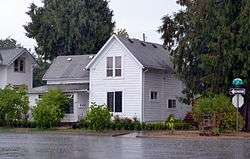
The historic district's Mary G. Reed House (historic name, ca. 1905) in 2013. | |
|
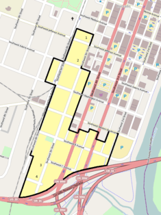
The Avery–Helm Historic District boundaries in Corvallis. | |
| Location | Corvallis, Oregon, roughly bounded by SW 2nd, 6th, and Jefferson Streets, and the Highway 20/34 Bypass[1] |
|---|---|
| Coordinates | 44°33′32″N 123°15′58″W / 44.558981°N 123.265994°WCoordinates: 44°33′32″N 123°15′58″W / 44.558981°N 123.265994°W |
| Area | 34 acres (14 ha)[1] |
| Built | ca. 1870 – 1949[1] |
| Architectural style | Bungalow, vernacular, Italianate, Gothic Revival, Queen Anne, Colonial Revival, American Foursquare, others[1] |
| NRHP Reference # | 99001716 |
| Added to NRHP | January 27, 2000 |
The Avery–Helm Historic District comprises a primarily residential portion of central Corvallis, Oregon, United States. Located on several of Corvallis's earliest plats, the 122 historic houses remaining in the district (as of 1999) present a window into the domestic aspects of the city's development from 1870 to 1949, providing a full industrial, socioeconomic, and architectural profile of that period.[1] The district was added to the National Register of Historic Places in 2000.[2]
See also
References
- 1 2 3 4 5 Dennis, Michelle L. (March 1999), National Register of Historic Places Registration Form: Avery–Helm Historic District (PDF), retrieved March 29, 2013.
- ↑ Oregon Parks and Recreation Department, Oregon Historic Sites Database, retrieved March 29, 2013.
External links
 Media related to Avery-Helm Historic District at Wikimedia Commons
- National Register of Historic Places photographic file
| Lists by county |   | |
|---|---|---|
| Portland lists | ||
| Other lists |
| |
This article is issued from Wikipedia - version of the 11/24/2016. The text is available under the Creative Commons Attribution/Share Alike but additional terms may apply for the media files.