Aux Rochers River
| Aux Rochers River | |
|---|---|
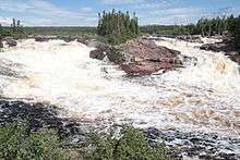
 The river in August 2012 | |
| Native name | Rivière aux Rochers |
| Country | Canada |
| Location |
Sept-Rivières Regional County Municipality Côte-Nord Quebec |
| Basin | |
| Main source |
Lake Walker 585 m (1,919 ft) |
| River mouth |
Saint Lawrence River at Port-Cartier 0 m (0 ft) |
| Basin size | 4,439 km2 (1,714 sq mi) |
| Physical characteristics | |
| Length | 30 km (19 mi) |
Aux Rochers River, in French Rivière aux Rochers (Rocky River), is a river in Sept-Rivières Regional County Municipality, Côte-Nord, Quebec, Canada.
Description

Aux Rochers River is about 30 kilometres long and has a catchment area of 4439 km². Its highest point is 585 metres above sea level.[1][2] Sourced from Lake Walker, the deepest lake in Quebec, the Aux Rochers River flows southeastward to the Saint Lawrence River at Port-Cartier. There it splits the city in two.
The river is hard to navigate due to a strong current. It also contains many rocks, hence its name. Some of the smaller rocks move to different places in the river each year.
As a visitor attraction
The river is popular for fishing, containing various species including salmon. Large salmon are known to migrate through the river. On June 24, 2013, the Association de protection de la rivière Aux Rochers reported that, during counting of migrating fish through the counting facility, of the 20 fish counted, many were MSW (multi sea winter) salmon weighing over 25 pounds.[3][4]
Aux Rochers River is also considered to be a scenic place and tourist destination as it has various areas of rapids and small falls.[5]
References
- ↑ "Fiche descriptive". gouv.qc.ca.
- ↑ http://www.bape.gouv.qc.ca/sections/mandats/La%20Romaine/documents/DA42.pdf
- ↑ "Good News for an Angling River in Quebec". atlanticsalmonfederation.org.
- ↑ "Québec Pêche". Québec Pêche.
- ↑ http://www.villeport-cartier.com/site.asp?page=element&nIDElement=5204
External links
Coordinates: 50°00′52″N 66°52′08″W / 50.014454°N 66.868825°W