Aure (river)
| Aure | |
|---|---|
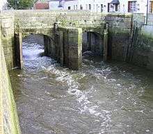 The Aure at Isigny-sur-Mer | |
| Country | France |
| Basin | |
| Main source | Lower Normandy |
| River mouth |
Vire 49°19′31″N 1°6′45″W / 49.32528°N 1.11250°WCoordinates: 49°19′31″N 1°6′45″W / 49.32528°N 1.11250°W |
| Progression | Vire→ English Channel |
| Physical characteristics | |
| Length | 82 km (51 mi) |
The Aure is a river in northwestern France[1] in the region of Lower Normandy. Its source is in Caumont-l'Éventé, and it flows into the river Vire in Isigny-sur-Mer. The largest town on the Aure is Bayeux.
History
In modern history, crossing of the Aure is noted in the advances of units of infantry of the United States as they undertook liberation of France from the Nazis in June, 1944.[2] The river leads to a small mill that formerely was used to make cotton.
Hydrology and water quality
The Aure river has relatively high turbidity and its brownish water is moderate in velocity due to the slight gradient of the watercourse, although the narrow channel in locations like Bayeux centre engenders higher surface velocities; pH levels have been measured at 8.35 in the centre of Bayeux near the Bayeux Tapestry Museum[3] and electrical conductivity of the waters have tested at 37 micro-siemens per centimetre. Turbidity has been measured at 13 centimetres by the Secchi disc method. At this reference location of Bayeux, summer flows are typically in the range of 50 cubic feet per second (1.4 m3/s).
Tributaries
- Le Lieu Gueroult (ruisseau)
- Ruisseau de la Baronnie
- Le Vession (ruisseau)
- L'Aurette (G)
- Ruisseau de Fumichon
- Ruisseau du Ponchot
- La Drôme (G) ~ 58 km long ~ its main affluent
- Le Cachiau (ruisseau)
- Le Douet du Val (ruisseau)
- Le Douet de Riloques (ruisseau)
- Le Douet de Courtelay (ruisseau)
- La Tortonne (G)
- L'Esque (G)
- Ruisseau du Moulin Dannebey
- Ruisseau de la Bellaie
References
- ↑ Atlas des Routes de France, Solar Press: Donnees IGN (2007)
- ↑ D-Day operations in Normandy by U.S. infantry
- ↑ Hogan, C. Michael, Water quality of freshwater bodies in France, Lumina Tech. Press, Aberdeen, Scotland (2006)