Attica, Indiana
| Attica | |
|---|---|
| City | |
|
Looking into Attica across the Wabash | |
| Nickname(s): Johnson I.N | |
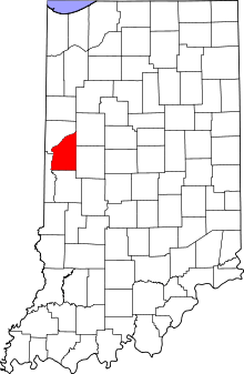 Fountain County's location in Indiana | |
 Attica Attica's location in Fountain County | |
| Coordinates: 40°17′25″N 87°14′49″W / 40.29028°N 87.24694°WCoordinates: 40°17′25″N 87°14′49″W / 40.29028°N 87.24694°W | |
| Country | United States |
| State | Indiana |
| County | Fountain |
| Township | Logan |
| Government | |
| • Mayor | Robert "Bob" Shepherd (R) |
| Area[1] | |
| • Total | 1.60 sq mi (4.14 km2) |
| • Land | 1.60 sq mi (4.14 km2) |
| • Water | 0 sq mi (0 km2) |
| Elevation[2] | 545 ft (166 m) |
| Population (2010)[3] | |
| • Total | 3,245 |
| • Estimate (2012)[4] | 3,217 |
| • Density | 2,028.1/sq mi (783.1/km2) |
| Time zone | EST (UTC-5) |
| • Summer (DST) | EDT (UTC-4) |
| ZIP code | 47918 |
| Area code | 765 |
| FIPS code[2][5] | 18-02620 |
| GNIS ID[2][5] | 430330 |
| Website |
www |

Attica is a city in Logan Township, Fountain County, Indiana, United States. The population was 3,245 at the 2010 census.
History
Attica was laid out by George Hollingsworth and platted by David Stump in 1825.[6] The completion of the Wabash and Erie Canal through the town in 1847 brought a considerable amount of growth to the area, and ended (in Attica's favor) a long-standing rivalry with the neighboring communities of Rob Roy, Williamsport and Covington.[7]
Attica is the nearest town to the location where Paul Dresser is believed to have written the state song, "On the Banks of the Wabash, Far Away", and the bridge over the Wabash River bears his name.
The Attica Downtown Historic District, Attica Main Street Historic District, Brady Street Historic District, Marshall M. Milford House, and Old East Historic District are listed on the National Register of Historic Places.[8]
Geography

Attica is located at 40°17′25″N 87°14′49″W / 40.29028°N 87.24694°W (40.290227, -87.246973)[9] along the Wabash River in Logan Township. U.S. Route 41, State Road 28, and State Road 55 intersect at Attica.
According to the 2010 census, Attica has a total area of 1.6 square miles (4.14 km2), all land.[1]
Demographics
| Historical population | |||
|---|---|---|---|
| Census | Pop. | %± | |
| 1860 | 1,713 | — | |
| 1870 | 2,273 | 32.7% | |
| 1880 | 2,150 | −5.4% | |
| 1890 | 2,320 | 7.9% | |
| 1900 | 3,005 | 29.5% | |
| 1910 | 3,335 | 11.0% | |
| 1920 | 3,392 | 1.7% | |
| 1930 | 3,700 | 9.1% | |
| 1940 | 3,760 | 1.6% | |
| 1950 | 3,862 | 2.7% | |
| 1960 | 4,341 | 12.4% | |
| 1970 | 4,262 | −1.8% | |
| 1980 | 3,841 | −9.9% | |
| 1990 | 3,457 | −10.0% | |
| 2000 | 3,491 | 1.0% | |
| 2010 | 3,245 | −7.0% | |
| Est. 2015 | 3,117 | [10] | −3.9% |

As of the 2010 United States Census, there were 3,245 people, 1,308 households, and 843 families residing here.[3] The population density was 2,028.3 inhabitants per square mile (783.1/km2). There were 1,507 housing units at an average density of 942.0 per square mile (363.7/km2).[12] The racial makeup was 97.8% white, 0.3% Asian, 0.2% American Indian, 0.1% black or African American, 0.6% from other races, and 1.0% from two or more races. Those of Hispanic or Latino origin made up 2.4% of the population.[3] In terms of ancestry, 26.3% were German, 14.1% were English, 13.9% were Irish, and 12.3% were American.[13]
Of the 1,308 households, 32.0% had children under the age of 18 living with them, 47.2% were married couples living together, 12.4% had a female householder with no husband present, 35.6% were non-families, and 30.3% of all households were made up of individuals. The average household size was 2.45 and the average family size was 3.00. The median age was 38.9 years.[3]
The median income for a household was $34,804 and the median income for a family was $52,669. Males had a median income of $45,682 versus $24,574 for females. The per capita income for was $21,287. About 13.3% of families and 16.3% of the population were below the poverty line, including 26.0% of those under age 18 and 13.9% of those age 65 or over.[14]
Points of interest
- The Devon Theater, a well-preserved Art Deco-style theater.
- The Badlands, an off-road park.
- The Heritage Days Festival, held annually in mid-September.
- The Attica UMC Motorsports Festival, held annually in late June.
- Cottrell Village, an 1850s restoration of two houses and a church.
- Ravine Park.
- Ouabache Park, on the Wabash River.
- McDonald Park.
- Robie's Restaurant
Notable people
- Grand Ole Opry founder George Dewey Hay, honored posthumously as a Sagamore of the Wabash in 1988.
References
- 1 2 "G001 - Geographic Identifiers - 2010 Census Summary File 1". United States Census Bureau. Retrieved 2015-07-28.
- 1 2 3 "Feature ID 430330". Geographic Names Information System. United States Geological Survey. Retrieved June 30, 2014.
- 1 2 3 4 "DP-1 Profile of General Population and Housing Characteristics: 2010 Demographic Profile Data". United States Census Bureau. Retrieved 2015-07-11.
- ↑ "Population Estimates". United States Census Bureau. Archived from the original on June 17, 2013. Retrieved 2013-06-25.
- 1 2 "FIPS55 Data: Indiana". FIPS55 Data. United States Geological Survey. February 23, 2006. Archived from the original on June 18, 2006. Retrieved June 30, 2014. External link in
|work=(help) - ↑ Hawes, George W.; Sutherland, James (1859). G. W. Hawes' Indiana State Gazetteer and Business Directory for 1858 and 1859. Geo. W. Hawes, Pub. and Proprietor. p. 10.
- ↑ Morrison, Carol Parks (2006). Presbyterian Pioneers. Xulon Press. p. 48. ISBN 978-1-60034-159-5.
- ↑ National Park Service (2010-07-09). "National Register Information System". National Register of Historic Places. National Park Service.
- ↑ "US Gazetteer files: 2010, 2000, and 1990". United States Census Bureau. 2011-02-12. Retrieved 2011-04-23.
- ↑ "Annual Estimates of the Resident Population for Incorporated Places: April 1, 2010 to July 1, 2015". Retrieved July 2, 2016.
- ↑ "Census of Population and Housing". Census.gov. Archived from the original on May 11, 2015. Retrieved June 4, 2015.
- ↑ "Population, Housing Units, Area, and Density: 2010". United States Census Bureau. Retrieved 2015-07-11.
- ↑ "DP02 SELECTED SOCIAL CHARACTERISTICS IN THE UNITED STATES – 2006-2010 American Community Survey 5-Year Estimates". United States Census Bureau. Retrieved 2015-07-11.
- ↑ "DP03 SELECTED ECONOMIC CHARACTERISTICS – 2006-2010 American Community Survey 5-Year Estimates". United States Census Bureau. Retrieved 2015-07-11.
External links
Municipalities and communities of Fountain County, Indiana, United States | ||
|---|---|---|
| Cities | ||
| Towns | ||
| Townships | ||
| Unincorporated communities | ||