Atok, Benguet
| Atok | ||
|---|---|---|
| Municipality | ||
| Municipality of Atok | ||
 | ||
| ||
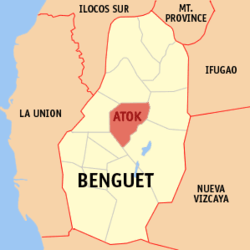 Location in the province of Benguet | ||
.svg.png) Atok Location within the Philippines | ||
| Coordinates: PH 16°35′N 120°42′E / 16.58°N 120.7°ECoordinates: PH 16°35′N 120°42′E / 16.58°N 120.7°E | ||
| Country | Philippines | |
| Region | Cordillera Administrative Region (CAR) | |
| Province | Benguet | |
| District | Lone district of Benguet | |
| Established | 1900 | |
| Barangays | 8 | |
| Government | ||
| • Mayor | Peter Buletin Alos | |
| Area[1] | ||
| • Total | 214.99 km2 (83.01 sq mi) | |
| Population (2015 census)[2] | ||
| • Total | 19,668 | |
| • Density | 91/km2 (240/sq mi) | |
| Time zone | PST (UTC+8) | |
| ZIP code | 2612 | |
| Dialing code | +63 (0)74 | |
| Income class | 4th class | |
| Website |
www | |

Atok is a fourth class municipality in the province of Benguet, Philippines. According to the 2015 census, it has a population of 19,668 people.[2]
History
Spanish period
The area of Atok was previously referred to by the natives and Spanish colonizers as Chontog, an Ibaloi word for "mountainous". Spanish military officials and missionaries arrived at Chontog in 1892, establishing precedencias (tax collection stations) in the area and its surrounding settlements.[3]
The Ibaloi phrase Nay patok shi Chontog, which means "on the mountain top", was later shortened to Atok.[4]
American period
During the American rule, Atok was established as one of the 19 townships of the province of Benguet, upon the issuance of Act No. 48 by the Philippine Commission on November 22, 1900.[5] [6]
On August 13, 1908, Benguet was established as a sub-province of the newly created Mountain Province with the enactment of Act No. 1876. As a result, six townships of Benguet were abolished, but Atok remained a constituent town of Benguet sub-province.[6]
World War II
During the Second World War, Atok was the scene of fierce pitch battles between the military forces of the 1st, 2nd, 11th, 12th, 13th, 15th and 16th Infantry Division of the Philippine Commonwealth Army, 1st Infantry Regiment of the Philippine Constabulary, the USAFIP-NL 66th Infantry Regiments, the Igorot and Cordilleran guerrilla fighters and the Japanese Imperial Army forces. The steep terrain along the Halsema road suited Filipino troops, the Philippine Commonwealth military, and guerrillas to mount ambushes against the Japanese forces. One of these battles took place in what is now “Guerrilla Saddle” located at km. 26, Caliking, Atok.[7]
Post-war Era

On June 25, 1963, then-President Diosdado Macapagal issued Executive Order No. 42 converting eight (8) of the thirteen (13) towns (designated as municipal districts) of Benguet into regular municipalities. Atok was among them.[8]
On June 18, 1966, the sub-province of Benguet was separated from the old Mountain Province and was converted into a regular province. Atok remained to be a component municipality of the newly established province.[6] [9]
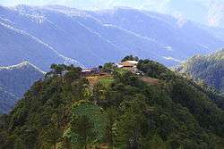
Geography
Atok has a land area of 21,499 hectares (53,130 acres).[1] The land is characterized as mountainous with many steep cliffs. The highest point in the Philippine Highway System is located at Barangay Paoay along Halsema Highway, at 2,255 metres (7,400 ft) above sea level.[7][10]
Atok is located in the heart of the province of Benguet. It is bounded by Kibungan on the north, Kabayan on the north-east, Bokod on the southeast, Tublay on the south-west, and Kapangan on the west.
Atok is 48 kilometres (30 mi) from Baguio City.
Climate
During the cold months of the year, the municipality experiences very low temperatures reaching 9 degrees Celsius. This causes frost to settle on the ground, causing millions of damage to crops, but drawing tourists to the town.[11][12]
| Climate data for Atok, Benguet, Philippines (2000-2012) | |||||||||||||
|---|---|---|---|---|---|---|---|---|---|---|---|---|---|
| Month | Jan | Feb | Mar | Apr | May | Jun | Jul | Aug | Sep | Oct | Nov | Dec | Year |
| Average high °C (°F) | 24 (75) |
24 (75) |
25 (77) |
26 (79) |
25 (77) |
25 (77) |
24 (75) |
23 (73) |
24 (75) |
24 (75) |
24 (75) |
24 (75) |
24.3 (75.7) |
| Average low °C (°F) | 13 (55) |
13 (55) |
15 (59) |
16 (61) |
16 (61) |
17 (63) |
16 (61) |
16 (61) |
16 (61) |
16 (61) |
15 (59) |
14 (57) |
15.3 (59.5) |
| Average precipitation mm (inches) | 22.8 (0.898) |
26.3 (1.035) |
54.8 (2.157) |
66.1 (2.602) |
313.1 (12.327) |
340.2 (13.394) |
640.7 (25.224) |
748.1 (29.453) |
601.3 (23.673) |
306.4 (12.063) |
131.2 (5.165) |
42.1 (1.657) |
3,293.1 (129.648) |
| Source: World Weather Online[13] | |||||||||||||
Barangays
Atok comprises 8 barangays.[1]
| PSGC | Barangay | Population | ±% p.a. | ||
|---|---|---|---|---|---|
| 2015[2] | 2010[14] | ||||
| 141101001 | Abiang | 8.9% | 1,757 | 1,766 | −0.10% |
| 141101002 | Caliking | 17.3% | 3,402 | 3,155 | +1.45% |
| 141101003 | Cattubo | 12.6% | 2,482 | 2,674 | −1.41% |
| 141101004 | Naguey | 8.8% | 1,723 | 1,723 | 0.00% |
| 141101005 | Paoay | 22.3% | 4,395 | 4,181 | +0.95% |
| 141101006 | Pasdong | 6.1% | 1,193 | 1,078 | +1.95% |
| 141101007 | Poblacion | 10.6% | 2,077 | 2,045 | +0.30% |
| 141101008 | Topdac | 13.4% | 2,639 | 2,620 | +0.14% |
| Total | 19,668 | 19,242 | +0.42% | ||
Demographics
| Population census of Atok | ||
|---|---|---|
| Year | Pop. | ±% p.a. |
| 1990 | 13,853 | — |
| 1995 | 14,862 | +1.33% |
| 2000 | 16,657 | +2.47% |
| 2007 | 19,253 | +2.02% |
| 2010 | 19,242 | −0.02% |
| 2015 | 19,668 | +0.42% |
| Source: Philippine Statistics Authority[2][14][15] | ||
The population of Atok, Benguet, in the 2015 census was 19,668 people,[2] with a density of 91 inhabitants per square kilometre or 240 inhabitants per square mile.
Education
Public schools
As of 2014, Atok has 22 public elementary schools and 2 public secondary schools.[16][17][18]
|
|
References
- 1 2 3 "Province: Benguet". PSGC Interactive. Makati City, Philippines: National Statistical Coordination Board. Retrieved 13 August 2013.
- 1 2 3 4 5 "CORDILLERA ADMINISTRATIVE REGION (CAR)". Census of Population (2015): Total Population by Province, City, Municipality and Barangay (Report). PSA. Retrieved 20 June 2016.
- ↑ "Municipality of Atok". Province of Benguet (official website). Retrieved 25 October 2014.
- ↑ "Municipality of Atok, Benguet". Department of Interior and Local Government - Cordillera Administrative Region. 29 April 2013. Archived from the original on 6 October 2014. Retrieved 25 October 2014.
- ↑ "Facts & Figures: Benguet Province". Philippine Statistics Authority - National Statistical Coordination Board - Cordillera Administrative Region. Retrieved 9 October 2014.
- 1 2 3 "History: Benguet Province". Province of Benguet (official website). Archived from the original on 19 October 2014. Retrieved 9 October 2014.
- 1 2 "Natural Attractions found in Atok". Province of Benguet. Retrieved 13 August 2013.
- ↑ "Executive Order No. 42, s. 1963: Declaring Certain Municipal Districts in the Philippines as Municipalities". Official Gazette of the Republic of the Philippines. Retrieved 25 October 2014.
- ↑ "Republic Act No. 4695: An Act Creating the Provinces of Benguet, Mountain Province, Ifugao and Kalinga-Apayao". Chan Robles Virtual Law Library. Retrieved 18 September 2014.
- ↑ Lancion, Jr., Conrado M.; de Guzman, Rey (cartography) (1995). "The Provinces". Fast Facts about Philippine Provinces (The 2000 Millenium ed.). Makati, Metro Manila: Tahanan Books. pp. 38–39. ISBN 971-630-037-9. Retrieved 16 January 2015.
- ↑ Diola, Camille (2 January 2014). "Icy 9-degree temperature frosts crops in Benguet town". The Philippine Star. Retrieved 16 September 2014.
- ↑ Cabreza, Vincent; Quitasol, Kimberlie (6 January 2014). "Benguet frost welcomed by visitors, hated by tillers". Philippine Daily Inquirer. Retrieved 16 September 2014.
- ↑ "Atok Monthly Climate Average, Philippines". World Weather Online. Retrieved 29 January 2016.
- 1 2 "CORDILLERA ADMINISTRATIVE REGION (CAR)". Census of Population and Housing (2010): Total Population by Province, City, Municipality and Barangay (Report). NSO. Retrieved 29 June 2016.
- ↑ "Province of Benguet". Municipality Population Data. LWUA Research Division. Retrieved 12 August 2013.
- ↑ "Masterlist of Public Elementary Schools for the School year 2012- 2013" (XLSX). Department of Education (Philippines), July 15, 2013. Retrieved 28 December 2014.
- 1 2 "Masterlist of Secondary Schools (School Year 2013- 2014)" (XLSX). Department of Education (Philippines), July 4, 2013. Retrieved 20 November 2014.
- 1 2 "Masterlist of Public Schools SY 2013-2014" (XLSX). Department of Education (Philippines), 22 October 2014. Retrieved 28 December 2014.
External links
| Wikimedia Commons has media related to Atok, Benguet. |
| Wikivoyage has a travel guide for Atok. |
 |
Kibungan | Kabayan | | |
| Kapangan | |
|||
| ||||
| | ||||
| Tublay | |
Bokod |
La Trinidad (capital) | |
| Municipalities | |
| Highly urbanized city |
|
| Barangays | |