Ashville, Pennsylvania
| Ashville, Pennsylvania | |
|---|---|
| Borough | |
.jpg) | |
 Map of Cambria County, Pennsylvania highlighting the town of Ashville | |
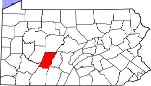 Map of Cambria County, Pennsylvania | |
 Ashville Map of Cambria County, Pennsylvania highlighting the town of Ashville | |
| Coordinates: 40°33′33″N 78°32′53″W / 40.55917°N 78.54806°WCoordinates: 40°33′33″N 78°32′53″W / 40.55917°N 78.54806°W | |
| Country | United States |
| State | Pennsylvania |
| County | Cambria |
| Settled | 1842 |
| Incorporated | 1887 |
| Government | |
| • Type | Borough Council |
| Area | |
| • Total | 0.18 sq mi (0.46 km2) |
| • Land | 0.18 sq mi (0.46 km2) |
| • Water | 0.0 sq mi (0.0 km2) |
| Elevation | 1,654 ft (504 m) |
| Population (2010) | |
| • Total | 227 |
| • Density | 1,278/sq mi (493.5/km2) |
| Time zone | Eastern (EST) (UTC-5) |
| • Summer (DST) | EDT (UTC-4) |
| Zip code | 16613 |
| Area code(s) | 814 |
Ashville is a borough (town) in Cambria County, Pennsylvania, United States. It is part of the Altoona, Pennsylvania Metropolitan Statistical Area. The population was 227 at the 2010 census.[1]
Geography
Ashville is located in northeastern Cambria County at 40°33′33″N 78°32′53″W / 40.55917°N 78.54806°W (40.559222, -78.548031).[2] It is in the valley of Clearfield Creek, a north-flowing tributary of the West Branch Susquehanna River, and the trace of eastern continental divide either passes through or is just east of town,[3] in the abutting Gallitzin Township, PA to the south.
Pennsylvania Routes 36 and 53 cross in the borough. Route 36 leads northwest 8 miles (13 km) to Patton and southeast 10 miles (16 km) to Altoona, while Route 53 leads north 15 miles (24 km) to Coalport and south 8 miles (13 km) to Cresson.
According to the United States Census Bureau, the borough of Ashville has a total area of 0.18 square miles (0.46 km2), all of it land.[1]
2013 shooting
On Friday, September 27, 2013, a shooting took place outside of Ashville in Allegheny Township on Bottom Road around 10 PM. At least three people were killed in what was initially reported to be a home invasion. A fourth person was taken to UPMC Altoona but later died from complications.[4]
Demographics
| Historical population | |||
|---|---|---|---|
| Census | Pop. | %± | |
| 1890 | 289 | — | |
| 1900 | 393 | 36.0% | |
| 1910 | 384 | −2.3% | |
| 1920 | 447 | 16.4% | |
| 1930 | 486 | 8.7% | |
| 1940 | 511 | 5.1% | |
| 1950 | 441 | −13.7% | |
| 1960 | 422 | −4.3% | |
| 1970 | 409 | −3.1% | |
| 1980 | 383 | −6.4% | |
| 1990 | 306 | −20.1% | |
| 2000 | 279 | −8.8% | |
| 2010 | 227 | −18.6% | |
| Est. 2015 | 219 | [5] | −3.5% |
| Sources:[6][7] | |||
As of the census[8] of 2010, there were 227 people, 102 households, and 62 families residing in the borough. The population density was 1,289.9 people per square mile (498.0/km²). There were 111 housing units at an average density of 630.8 per square mile (238.1/km²). The racial makeup of the borough was 97.4% White, 0.9% Black or African American, 0.4% Native Hawaiian, 0.9% from other races, and 0.4% from two or more races. Hispanic or Latino of any race were 0.9% of the population.
There were 102 households, out of which 27.5% had children under the age of 18 living with them, 34.3% were married couples living together, 19.6% had a female householder with no husband present, and 33.6% were non-families. 39.2% of all households were made up of individuals, and 17.7% had someone living alone who was 65 years of age or older. The average household size was 2.23 and the average family size was 2.87.
In the borough the population was spread out, with 24.2% under the age of 18, 7.5% from 18 to 24, 22.9% from 25 to 44, 22.0% from 45 to 64, and 23.3% who were 65 years of age or older. The median age was 40 years. For every 100 females there were 102.7 males. For every 100 females age 18 and over, there were 95.5 males.
The median income for a household in the borough was $38,409, and the median income for a family was $45,208. Males had a median income of $35,417 versus $36,667 for females. The per capita income for the borough was $22,999. About 12.3% of families and 15.6% of the population were below the poverty line, including 27.7% of those under the age of eighteen and none of those sixty five or over.
Businesses
- Woody Lodge Winery LLC
- Cole's Auto Repair
- All Star Auto
- Fine Furniture Resale & Time Worn Primitives
- Dave Conrad's Handyman Services
- Pettenati's Flooring
- Dee's Country Cafe
- Joelynn's Quick Stop
- Ashville VFW
- Ashville Inn
- Hobo Hotel
- Fred's Pallet and Road Cones
- Gibbons Funeral Home
References
| Wikimedia Commons has media related to Ashville, Pennsylvania. |
- 1 2 "Geographic Identifiers: 2010 Demographic Profile Data (G001): Ashville borough, Pennsylvania". U.S. Census Bureau, American Factfinder. Retrieved March 11, 2015.
- ↑ "US Gazetteer files: 2010, 2000, and 1990". United States Census Bureau. 2011-02-12. Retrieved 2011-04-23.
- ↑ See commons source topomap for Kittanning Run, Commons:File:USGS National Map viewer--topo map Mode showing Source of Kittanning Run, Pennsylvania location (40.5406, -78.5132) in Gallitzin Township, PA, near Altoona,antd-en.
- ↑ http://www.wearecentralpa.com/story/several-dead-cambria-county/d/story/-ObQqZZjOUWMupNxytmUeg
- ↑ "Annual Estimates of the Resident Population for Incorporated Places: April 1, 2010 to July 1, 2015". Retrieved July 2, 2016.
- ↑ "Census of Population and Housing: Decennial Censuses". United States Census Bureau. Retrieved 2012-03-04.
- ↑ "Incorporated Places and Minor Civil Divisions Datasets: Subcounty Resident Population Estimates: April 1, 2010 to July 1, 2012". Population Estimates. U.S. Census Bureau. Archived from the original on 17 June 2013. Retrieved 11 December 2013.
- ↑ "American FactFinder". United States Census Bureau. Archived from the original on 2013-09-11. Retrieved 2008-01-31.
Municipalities and communities of Cambria County, Pennsylvania, United States | ||
|---|---|---|
| City | | |
| Boroughs |
| |
| Townships | ||
| CDPs | ||
| Unincorporated communities | ||
| Footnotes | ‡This populated place also has portions in an adjacent county or counties | |