Ashtarak
Coordinates: 40°17′51″N 44°21′42″E / 40.29750°N 44.36167°E
| Ashtarak Աշտարակ | ||
|---|---|---|
|
From top left: Ashtarak town • Ashtarak bridge of 1664 Karmravor Church • Saint Marianeh Church • Surp Sarkis Church House-museum of Perch Proshyan • the statue of Nerses Ashtaraketsi | ||
| ||
 Ashtarak Աշտարակ | ||
| Coordinates: 40°17′51″N 44°21′42″E / 40.29750°N 44.36167°E | ||
| Country |
| |
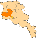
| Marz | Aragatsotn | |
| First mentioned | 9th century | |
| City status | 1963 | |
| Government | ||
| • Mayor | Armen Antonyan | |
| Area | ||
| • Total | 7.5 km2 (2.9 sq mi) | |
| Elevation | 1,110 m (3,640 ft) | |
| Population (2011 census) | ||
| • Total | 18,834 | |
| • Density | 2,500/km2 (6,500/sq mi) | |
| Time zone | AMT (UTC+4) | |
| Postal code | 0201-0205 | |
| Area code(s) | (+374) 232 | |
| Website | Official website | |
| Sources: Population[1] | ||


Ashtarak (Armenian: Աշտարակ), is a town in the Aragatsotn Province of Armenia, located on the left bank of Kasagh River along the gorge, northwest of the capital Yerevan. It is the administrative centre of the Aragatsotn province. Ashtarak is an important crossroad of routes for the Yerevan–Gyumri–Vanadzor rectangle.
The town plays a great role in the national economy as well as the cultural life of Armenia through several industrial enterprises and cultural institutions. It has developed as a satellite town of Yerevan. The nearby village of Mughni is part of the Ashtarak municipality.
As of the 2011 census, the population of the town was 18,834. However, as per the 2016 official estimate, the population of Ashtarak is 18,000.[2]
Etymology
The name of "Ashtarak" is the Armenian word for tower or fortress. However, according to linguist Grigor Ghapantsyan, the name of Ashtarak is derived from Ishtar (Ashtar); the Assyrian and Babylonian goddess of fertility. Contrary, the latest historical researches proved that the name of Ishtar was never used in the Armenian mythology during the ancient times. Instead, the goddess of fertility was known as Shardi or Sardi in the ancient kingdom of Urartu, and later became to be known as Astghik among the Armenian monks.
Other linguists suggest that the name of Ashtarak is related either with the legendary figure in the Armenian history Shidar; the son of king Artavasdes I of Armenia, or with Sarduri II; the king of Urartu.[3]
History

According to Movses Khorenatsi, Aramaniak -the son of the patriarch and founder of the Armenian nation Hayk- along with his clan, settled in the area of modern-day Aragatsotn. The cemeteries of Verin Naver archaeological site -located 3 km west of Ashtarak- are dating back to the period between the 24th and 14th centuries BC.
Historically, the area of modern-day Ashtark was part of the Aragatsotn canton of Ayrarat province of the ancient Kingdom of Armenia, the town is one of the oldest settlements in Armenia with many historical and cultural monuments that demonstrate the valuable patterns of Armenian architecture.
In the history of the Armenian highland, Ashtarak was mentioned as a rural settlement for the first time during the 9th century.[4] However, the importance of Ahtarak has declined during the following centuries under the rule of the foreign powers. Between the 11th and 15th centuries, the entire region of Aragatsotn along with the rest of the historic territories of Armenia suffered from the Seljuk, Mongol, Ag Qoyunlu and Kara Koyunlu invasions, respectively. At the beginning of the 16th century, Ahtarak became part of the Erivan Beglarbegi within the Safavid Persia. Within the 17th century, the town was entirely rebuilt. During the first half of the 18th century, Ashtarak became part of the Erivan Khanate under the rule of the Afsharid dynasty and later under the Qajar dynasty of Persia. Ashtarak was the site of the Battle of Oshakan in August 1827, which resulted in a Persian victory, during the Russo-Persian War of 1826-1828.[5] It remained under the Persian rule until 1827-1828, when Eastern Armenia was ceded to the Russian Empire as a result of the same Russo-Persian War of 1826–28 and the signing of the Treaty of Turkmenchay.

After the fall of the Russian Empire in 1917, Ashtarak was included within the First Republic of Armenia declared on 28 May 1918. However, after 2 years of brief independence, Armenia became part of the Soviet Union in December 1920. From 1930 until 1995, Ashtarak was the centre of the Ashtarak raion. During that period, Ashtarak was granted the status of a town in 1963.
After the independence of Armenia in 1991, Ashtarak became the capital of the newyly-formed Aragatsotn Province as a result of the territorial administration reform of 1995.
Geography


Ashtarak is located on the left bank of Kasagh River, 13 km to the northwest of the capital Yerevan, at an approximate height of 1110 meters above sea level.
The town occupies the central point between the Ararat plain from the south and the mountains of Aragats from the north. The area is rich with water resources. The fountains of Saghmosavan, Nazrevan and Shroshor are the main sources of drinking water for the town.
The town is divided into 4 districts: Old Ashtarak on the right bank of Kasagh river, Dzakhap (literally meaning left bank) on the left side of Kasagh, Gitavan and Bagavan. The village of Mughni -included within the municipality of Ashtarak- is located to the north of the town.[6] The valley of Ashtarak commonly known as Ashtaraki dzor is a major destination for visitors from Yerevan and other nearby settlements.
Ashtarak has a cold climate during winters with mildly hot summers.
Demographics
Ashtarak is primarily inhabited by Armenians who belong to the Armenian Apostolic Church. The regulating body of the church is the Diocese of Aragatsotn with the Saint Mesrop Mashtots Cathedral in Oshakan.
Here is the population timeline of Ashtarak since 1831:
| Date | Population | Note(s) |
|---|---|---|
| 1831[7] | 826 | |
| 1891[8] | 2,550 | overwhelmingly populated by Armenians |
| 1914[7] | 4,867 | |
| 1926[9] | 4,853 | 99.7% Armenians |
| 1959[7] | 7,563 | |
| 1972[7] | 13,900 | |
| 2001[10] | 18,915 | de facto population |
| 2011[10] | 18,834 | de facto population |
| 2016[10] | 18,000 | de facto population |
Culture
Ashtarak has a cultural palace along with many public libraries. The town is also home to the house-museum of novelist Perch Proshyan founded in 1948, is located in Ashtarak within the Proshyan family house. It was last restored in 2008.[11]
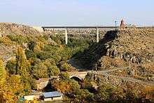
The 17th-century bridge of Ashtarak on Kasagh River is among the interesting sites of the town. It is located in the gorge just below the church of Saint Sarkis. It was built in 1664 by the efforts of Mahdesi Khoja Grigor; a wealthy merchant from Kanaker. The bridge features 3 arches that are unequal in size.
The churches of Spitakavor, Karmravor and Tsiranavor

According to a legend, 3 sisters lived in Ashtarak, all of whom fell in love with the same man, prince Sarkis. The elder 2 sisters decided to commit suicide in favour of the youngest one. One wearing an apricot-orange dress and the other wearing a red dress, they threw themselves into the Ashtarak gorge. When the youngest sister found out, she put on a white dress and also threw herself into the gorge. Sarkis then became a hermit and three small churches appeared at the edge of the gorge, named after the sisters' dress colours.
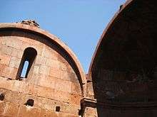
The best preserved one among the three churches is the Karmravor Church (meaning reddish for its dome colour), dating back to the 7th century, dedicated to the Holy Mother of God (Surp Astvatsatsin). It has a small cruciform central-plan, with a reddish/apricot coloured dome, and an octagonal drum. Other churches include, Spitakavor (meaning whitish because of its colour) built between the 5th and 6th centuries, and Tsiranavor (meaning apricot-coulored) built between the 13th and 14th centuries, both are located along the edge of the gorge.
Saint Marianeh Church
The largest church of the town is the Saint Marianeh Church located at the center of Ashtarak. It was built in 1271 and has a rectangular plan from outside and a cruciform type plan from inside with an octagonal drum above. A belfry was added in 1838.
Saint Sarkis Church
The 19th-century church of Surp Sarkis built on an old foundation, is situated on an attractive point at a promontory overlooking the gorge and offers a fine view to the above-mentioned three churches. The external walls of the structure were almost completely restored recently while the interior walls remain the same. Some pieces of the outer walls remain sitting next to the church with carvings on them.
Walnut Festival
The Ashtarak Walnut Festival is taking place every year during the month of October to promote the famous walnut of Ashtarak. It was first celebrated in 2012.[12]
Transportation
Ashtarak is a satellite of Yerevan and connected with the capital through the Ashtarak highway. The M-1 Motorway connects Ashtarak with northwestern Armenia, including the city of Gyumri, while the M-3 Motorway connects the town with northeastern Armenia up to the Georgian border.
Economy

Ashtarak is one of the major industrial centre of Aragatsotn Province. The industrial sector of the town is based on food-processing, dairy products and beverages, mainly processing the domestic raw materials and grapes.
Ashtarak is home to the "Ashtarak-Kat" company (founded in 1995), the leading ice-cream and dairy products manufacturer in Armenia. The town is also home to the "Gourmet Dourme" chocolate factory founded in 2007, the "P & D Group Armenia" for plastic containers founded in 2007, as well as the "Milen Art" plant and the "Kharam Cooperative" for building materials production.
With several restaurants and recreation areas, the valley of Kasagh river -locally known as Ashtaraki dzor- is a major destination for visitors from Yerevan and other areas.
Education
Ashtarak is home to 7 public education schools, 6 kindergartens and 4 art schools. Many museums and public libraries are operating in the city.
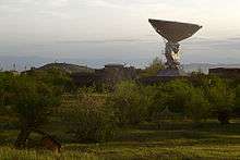
Ashtarak is also home to two major research institutions: the Mikael Ter-Mikaelian Institute for Physical Research[13] and the Institute of Radiophysics and Electronics.[14]
Sport
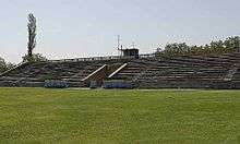
FC Mika was founded in 1999 on the basis of the merger of 2 football clubs: Mika Ashtarak and Kasagh Ashtarak[15] Under the merger, the name of the new club became Mika-Kasagh Ashtarak. However, the merger only lasted for 1 year; until 2000. Kasagh Ashtarak restored its original name, keeping their logo, history and statistics, while FC Mika settled for being a new club. In 2007, Mika was relocated from Ashtarak to Yerevan. The only stadium of the city is Kasaghi Marzik Stadium with a capacity of 3,500 spectators.
Ashtarak is also home to the "Ayrudzi" horse riding club.
International relations
Twin towns – Sister cities
Ashtarak is twinned with:
 Alfortville, France (since 1993).
Notable natives

- Nerses V Ashtaraketsi (1770–1857), Catholicos of all Armenians.
- Perch Proshyan (1837–1907), novelist.
- Smbat Shahaziz (1840–1908), poet.
- Norair Sisakian (1907–1966) Soviet Armenian biochemist and one of the founders of space biology.
- Gevorg Emin (1918–1998), poet.
- Emil Gabrielian (1931-2010), Armenian physician.
- Vardges Petrosyan (1932–1994), playwright and novelist.
References
- ↑ Aragatsotn
- ↑ Population estimate of Armenia as of 01.01.2016
- ↑ Ashtarak Archived March 20, 2013, at the Wayback Machine.
- ↑ Armstats:Aragatsotn Marz
- ↑ Ekbal, Kamran (2002). "EʿTEMĀD-AL-DAWLA, ĀQĀ KHAN NŪRĪ". Encyclopaedia Iranica.
- ↑ Ashtarak tert: About Ashtarak
- 1 2 3 4 "Հայաստանի Հանրապետության բնակավայրերի բառարան" (PDF). Armenian State Cadaste. 2008. p. 23.
- ↑ "Аштарак". Brockhaus and Efron Encyclopedic Dictionary Volume IIa (in Russian). 1891. pp. 555–556.
- ↑ http://ethno-kavkaz.narod.ru/echmiadzin26.html
- 1 2 3 http://armstat.am/file/doc/99480653.pdf
- ↑ Charents Museum of Literature and Arts
- ↑ Ashtarak Walnut Festival
- ↑ Institute of Physical Research
- ↑ Institute of Radiophysics and Electronics
- ↑ History - Mika Football Club, from fcmika.am, retrieved 1 May 2009
External links
| Wikimedia Commons has media related to Ashtarak. |
- Astharak monthly newspaper
- Armeniapedia.org article on the region
-
 Ashtarak travel guide from Wikivoyage