Ashover
| Ashover | |
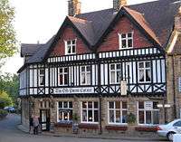 The Old Poets' Corner |
|
 Ashover |
|
| Population | 1,905 (Including Littlemoor. 2011) |
|---|---|
| OS grid reference | SK349630 |
| Civil parish | Ashover |
| District | North East Derbyshire |
| Shire county | Derbyshire |
| Region | East Midlands |
| Country | England |
| Sovereign state | United Kingdom |
| Post town | CHESTERFIELD |
| Postcode district | S45 |
| Dialling code | 01246 |
| Police | Derbyshire |
| Fire | Derbyshire |
| Ambulance | East Midlands |
| EU Parliament | East Midlands |
| UK Parliament | North East Derbyshire |
|
|
Coordinates: 53°09′47″N 1°28′37″W / 53.163°N 1.477°W
Ashover is a village and civil parish in the English county of Derbyshire. It is in the North East Derbyshire district of the county. The population of the civil parish taken at the 2011 Census was 1,905.[1] It sits in a picturesque valley, not far from the town of Matlock and the Peak District national park.
The centre of the village is a conservation area. The River Amber flows through the village. Although Ashover is a small settlement, the actual ward boundaries of the village extend for many miles, including the nearby settlements of Alicehead, Alton, Ashover Hay, Farhill, Kelstedge, Littlemoor, Milltown, Spitewinter, Stone Edge and Uppertown. The two major roads, running through the parish, are the A632 from Matlock to Chesterfield, and the A615 from Matlock to Alfreton. The area along that part of the A615 is named Doehole. Slack is a small hamlet, within the parish, which is south west of Kelstedge on the A632; nearby to there, on Robridding Road (off Wirestone Lane), is the Eddlestow Lot Picnic Site, which has been developed in the former Wirestone Quarry: it is surrounded by heathland vegetation. The picnic site provides a good base to explore the local Public Rights of Way. Circular walks are waymarked from the car park, a leaflet is available by contacting the County Council. There is public access into many of the adjacent Forestry Commission owned woodlands. The site has plants including heather and bilberry.[2][3] The other numbered roads in the parish are the B5057 from near North Brittain to Stone Edge, the B6036 between Kelstedge and Dalebank running past Ashover itself, and the B6014 from near Butterley to just past Ashover Hay. Fallgate is a hamlet beside the River Amber, in the south-east corner of the parish, off the B6036 to Woolley Moor and Handley.
History
Known in Saxon times as Essovre (possibly 'beyond the ash trees' or 'ash tree slope'[4]), Ashover was probably in existence during the first taxation survey of England by King Alfred in 893. However, the first written reference to the village occurs in the Domesday Book of 1086, in which Ashover is owned by Ralph fitzHubert[5] and is credited with a church, a priest, several ploughs, a mill. It had previously had a taxable value of four pounds, but it was revalued at thirty shillings.[6]
Ashover was the scene of a confrontation between the Royalists and the Roundheads during the English Civil War in the 17th century. The Roundheads, short of ammunition, demolished the windows of the church and used the lead to make bullets. They also reduced nearby Eastwood Hall to ruins; all that can be seen today are the ivy-clad remains. Royalists slaughtered livestock and drank all the wine and ale in the cellars of Eddlestow Hall while the owner Sir John Pershall was away. Job Wall, the landlord of the Crispin Inn public house, refused entry to the army, telling them they had had too much to drink. But they threw him out and drank the ale, pouring what was left down the street. Outside, affixed to the front wall of the pub is a signboard with a history of the inn.
Ashover's industrial history is linked with lead mining and quarrying, both of which date back to Roman times. Butt's Quarry is a large disused example, previously excavated by the Clay Cross Company for its works three miles (5 km) away. During the Second World War, prisoners of war held at Clay Cross were taken daily to the quarry to make concrete blocks. It is now home to a wide range of different species, including jackdaws which nest on the quarry face. Part of the village was home to the stocking frame knitting industry, which once rivalled lead mining in importance. The area is called Rattle, which is believed to be a reference to the noise made by the machinery.
Electricity came to the valley in the 1920s, but the village was not connected to the National Grid until a decade later. Some outlying settlements were not connected until after the Second World War. It was not until 1967 that gas street lights were replaced by electric lighting.
Until 1963, there was a hydro in the village, sourcing its own private water supply from a tank on a hillside. Ashover had two such institutions, which were popular in the 19th century due to the belief in 'healing water'. Subsequently purchased by the electricity board, the building is today divided into private apartments, with further expensive new houses built in the grounds.
Ashover Golf Club (now defunct) was founded in 1905. The club disappeared in the late 1920s.[7]
The Fabrick

To the east of the village is a gritstone boulder and viewpoint locally known as 'The Fabrick' or 'Ashover Rock'. The Fabrick sits on an area of heathland 299 metres above sea level. It is the highest viewpoint for a considerable distance, and the majority of the landscape east of this point to the coast is lower. Consequently, on a clear day, excellent views can be seen of nearby Chesterfield with its famous Crooked Spire, Bolsover Castle, Hardwick Hall, some suburbs of the South Yorkshire city of Sheffield, the surrounding counties of Nottinghamshire, Leicestershire, Staffordshire and, if the atmospheric conditions are right, it is possible to observe Lincoln Cathedral, around 40 miles (64 km) distant, with a telescope.
Other distant landmarks that can be seen are several power stations by the River Trent on the Nottinghamshire-Lincolnshire border. These are West Burton, near Gainsborough and Cottam. Further to the north east, the cooling towers and chimneys of Drax Power Station in North Yorkshire can be observed with binoculars, but due to the curvature of the earth the buildings themselves cannot be viewed. Further to the south, Ratcliffe-on-Soar Power Station can be seen, around 23 miles (37 km) away on the Nottinghamshire-Leicestershire border.
Next to The Fabrick is a disused Royal Observer Corps monitoring station, which was abandoned in 1991.[8] However, it is opened up occasionally by enthusiasts. For many years, The Fabrick was privately owned by the "Bassett" sisters who were descendants of the family made famous for creating "Bassetts Liquorice Allsorts",[9] but in 2006 was donated to Derbyshire County Council.[10] In the Victorian period, there was a stone folly on the top of the Fabrick, no trace of which remains today.
On important days in the pagan calendar, morris dancers gather.
The Youth Club, based at the village hall, organise night walks on Thursday evenings.
Fame
The village is famous for the Ashover Light Railway, which was owned and operated by the Clay Cross Company from 1925 to 1950. Along with Crich and Matlock, the village was used for a time as a location for the ITV drama series Peak Practice. Ashover won the Calor Village of the Year competition in 2005.
Geography
 |
Chatsworth House & Bakewell = 9 miles | Chesterfield = 5 miles | Old Tupton = 3 miles | |
| Peak District & Youlgreave = 8 miles | |
Clay Cross = 3 miles | ||
| ||||
| | ||||
| Matlock = 4 miles | Ambergate = 7 miles | Shirland = 4 miles |
See also
References
- ↑ "Civil Parish population 2011". Neighbourhood Statistics. Office for National Statistics. Retrieved 18 March 2016.
- ↑ "Derbyshire County Council: Leisure and Culture : Wildlife Amenity : Eddlestow Lot Picnic Site". Retrieved 3 March 2014.
- ↑ "UK Car Parks : Eddlestow Lot Car Park, Ashover". Retrieved 3 March 2014.
- ↑ "Ashover". Key to English Place-names. English Place Name Society at the University of Nottingham. Retrieved 21 August 2013.
- ↑ Ralph fitzHubert held a considerable number of manors including several in Derbyshire given to him by the King. These included obviously Ashover but also included lands in Eckington, Barlborough, Whitwell, Stretton, Stoney Middleton, Crich, Ogston, Ingleby, Wirksworth and Hathersage
- ↑ Domesday Book: A Complete Translation. London: Penguin, 2003. ISBN 0-14-143994-7 p.751
- ↑ “Ashover Golf Club”, “Golf’s Missing Links”.
- ↑ Ashover ROC post
- ↑ Ashover Parish Council - Royal visit Archived 4 September 2011 at the Wayback Machine.
- ↑ "Archived copy" (PDF). Archived from the original (PDF) on 22 February 2012. Retrieved 2009-09-18.
External links
| Wikimedia Commons has media related to Ashover. |
- Ashover Parish Council
- Ashover-info
- Ashover website
- Information about the disused ROC station
- Ashover in the Domesday Book