Arthur's Pass
| Arthur's Pass | |
|---|---|
| Township | |
|
Arthur's Pass Village | |
 Arthur's Pass | |
| Coordinates: 42°56′43.4″S 171°33′56.4″E / 42.945389°S 171.565667°ECoordinates: 42°56′43.4″S 171°33′56.4″E / 42.945389°S 171.565667°E | |
| Country | New Zealand |
| Region | Canterbury |
| District | Selwyn |
| Founded | 1906 (originally named Bealey Flat) |
| Electorates |
Selwyn Te Tai Tonga |
| Area | |
| • Total | 0.6 km2 (0.2 sq mi) |
| Elevation | 739 m (2,425 ft) |
| Population | |
| • Total | 29 |
| Time zone | NZST (UTC+12) |
| • Summer (DST) | NZDT (UTC+13) |
| Postcode | 7654 |
| Area code(s) | 03 |
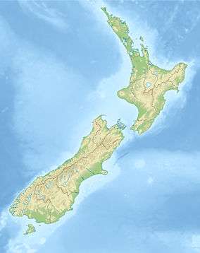
Arthur's Pass, previously called Camping Flat then Bealey Flats, and for some time officially Arthurs Pass, is a township in the Southern Alps of the South Island of New Zealand, located in the Selwyn district. It is a popular base for exploring Arthur's Pass National Park.
Arthur's Pass township is about 5 km south of the mountain pass with the same name. Its elevation is 740 metres above sea level surrounded by beech forest. The Bealey River runs through the township. The town is located 153 km from Christchurch a 2-hour drive on SH 73.
Naming and history
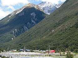
The township and the pass are named after Sir Arthur Dudley Dobson (1841–1934). Arthur Dobson had been tasked by the Chief Surveyor, Thomas Cass, to find out if there was an available pass out of the Waimakariri watershed into valleys running to the West Coast. In 1864, his brother Edward joined him and accompanied him into the valley of the Otira River. A West Coast Māori Chief, Tarapuhi, told Arthur of a pass that Māori hunting parties occasionally used. When Arthur returned to Christchurch, he sketched the country he had traversed and included it in a report to Cass. Arthur Dobson did not name the pass, which he found very steep on the western side.[1] Dobson named the site that became the township Camping Flat.
When the gold rush began, a committee of businessmen offered a £200 prize for anyone who would find a better or more suitable pass from Canterbury to the West Coast. At the same time, Edward Dobson (Arthur's father) was sent to examine every available pass between the watershed of the Taramakau, Waimakariri, and the Hurunui, and after examining passes at the head of every valley he reported that "Arthur's" pass was by far the most suitable for the direct crossing.[1]
The township, then named Bealey Flats after the second Superintendent, Samuel Bealey, was originally built as a construction village for the building of the Otira Tunnel, which was started on 14 January 1908.[2] Arthur's Pass township was reached by the railway in 1914, while the Westland section having advanced to Otira. Construction of the tunnel was very slow. The tunnel was finally completed in 1923. The TranzAlpine Express passes through Arthur's Pass and the Otira Tunnel as part of its 223 kilometres (139 mi) trek from Christchurch to Greymouth. The trip is considered one of the world's great train journeys for the scenery and views.
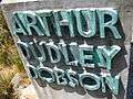
A power station was built below the Devil's Punchbowl Falls to provide electricity for the tunnel construction and the village itself.
In 1929 the Arthur’s Pass National Park was created, New Zealand's third National Park.[3][4]
The Geographic Board had a policy of omitting apostrophe in place names, and the name was officially changed to Arthurs Pass. This caused a great upset with the local population, and the Minister of Lands reinstated the old version with the apostrophe. Since 16 September 1975, the post office also adopted the spelling with the apostrophe.[3]
Facilities and attractions
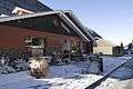
The township has a DOC ranger station, which also accommodates a visitor information and an informative display room. Visitor accommodation is provided, from camp ground up to hotel standard. The township provides a general store, a petrol station, tea rooms and restaurants.
There are also several good walks from here, including the Devil's Punchbowl Falls,[5] Bealey Valley[6] and Avalanche Peak.[7] The mischievous kea (New Zealand mountain parrot) can be found here.
The club skifield Temple Basin is nearby and is a popular attraction through winter.
The town can be reached by The Tranz Alpine Express train on the famous Midland Line. State Highway 73 also passes through the town.
- Photo gallery
-
Memorial at the mountain pass
-
Devil's Punchbowl Fall
-

Bealey River at Arthur's Pass
-

Arthur's Pass train station
-
Wobbly Kea Cafe
-
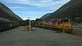
Two coal trains passing at Arthur's Pass station, June 2015.
References
- 1 2 McLintock, A. H. (22 April 2009). "DOBSON BROTHERS". Te Ara - the Encyclopedia of New Zealand. Retrieved 30 September 2011.
- ↑ http://paperspast.natlib.govt.nz/cgi-bin/paperspast?a=d&d=TC19080115.2.10 Colonist, Volume L, Issue 12140, 15 January 1908, Page 2; accessed 1 January 2010
- 1 2 http://www.nzhistory.net.nz/timeline&new_date=12/3 Article on Arthur's Pass on NZ History website; accessed 1 January 2010
- ↑ Reed, A. W. (2010). Peter Dowling, ed. Place Names of New Zealand. Rosedale, North Shore: Raupo. p. 31. ISBN 978-0-14-320410-7.
- ↑ Short walking tracks in Arthur's Pass, Department of Conservation.
- ↑ Half-day walks in Arthur's Pass, Department of Conservation.
- ↑ Day walks in Arthur's Pass, Department of Conservation.
External links
| Wikimedia Commons has media related to Arthur's Pass. |