Arrondissement of Redon
| Redon | |
|---|---|
| Arrondissement of France | |
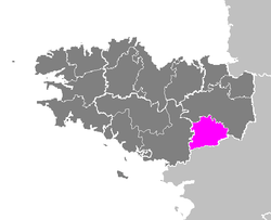 Location of Redon in Brittany | |
| Country | France |
| Region | Brittany |
| Department | Ille-et-Vilaine |
| Communes | 52 |
| Subprefecture | Redon |
| Area¹ | |
| • Total | 1,335 km2 (515 sq mi) |
| Population (2013) | |
| • Total | 105,580 |
| • Density | 79/km2 (200/sq mi) |
| ¹ French Land Register data, which exclude lakes, ponds, and glaciers larger than 1 km² as well as the estuaries of rivers. | |
The arrondissement of Redon is an arrondissement of France in the Ille-et-Vilaine department in the Brittany region. It has 52 communes.
Composition
Cantons
The cantons of the arrondissement of Redon are:
- Bain-de-Bretagne
- Bruz (partly)
- Guichen
- Redon
Communes
The communes of the arrondissement of Redon, and their INSEE codes, are:
- Bain-de-Bretagne (35012)
- Bains-sur-Oust (35013)
- Baulon (35016)
- La Bosse-de-Bretagne (35030)
- Bourg-des-Comptes (35033)
- Bovel (35035)
- Bruc-sur-Aff (35045)
- Les Brulais (35046)
- Campel (35048)
- Chanteloup (35054)
- La Chapelle-Bouëxic (35057)
- La Chapelle-de-Brain (35064)
- Comblessac (35084)
- La Couyère (35089)
- Crevin (35090)
- La Dominelais (35098)
- Ercé-en-Lamée (35106)
- Goven (35123)
- Grand-Fougeray (35124)
- Guichen (35126)
- Guignen (35127)
- Guipry-Messac (35176)
- Laillé (35139)
- Lalleu (35140)
- Langon (35145)
- Lassy (35149)
- Lieuron (35151)
- Lohéac (35155)
- Loutehel (35160)
- Maure-de-Bretagne (35168)
- Mernel (35175)
- La Noë-Blanche (35202)
- Pancé (35212)
- Le Petit-Fougeray (35218)
- Pipriac (35219)
- Pléchâtel (35221)
- Poligné (35231)
- Redon (35236)
- Renac (35237)
- Sainte-Anne-sur-Vilaine (35249)
- Sainte-Marie (35294)
- Saint-Ganton (35268)
- Saint-Just (35285)
- Saint-Malo-de-Phily (35289)
- Saint-Senoux (35312)
- Saint-Sulpice-des-Landes (35316)
- Saint-Séglin (35311)
- Saulnières (35321)
- Le Sel-de-Bretagne (35322)
- Sixt-sur-Aff (35328)
- Teillay (35332)
- Tresbœuf (35343)
External links
Coordinates: 47°39′00″N 2°05′00″W / 47.6500°N 2.0833°W
This article is issued from Wikipedia - version of the 4/24/2016. The text is available under the Creative Commons Attribution/Share Alike but additional terms may apply for the media files.