Arrondissement of Montpellier
| Montpellier | |
|---|---|
| Arrondissement of France | |
 | |
| Country | France |
| Region | Occitanie |
| Department | Hérault |
| Communes | 93 |
| Prefecture | Montpellier |
| Area¹ | |
| • Total | 1,295 km2 (500 sq mi) |
| Population (2013) | |
| • Total | 689,922 |
| • Density | 530/km2 (1,400/sq mi) |
| ¹ French Land Register data, which exclude lakes, ponds, and glaciers larger than 1 km² as well as the estuaries of rivers. | |
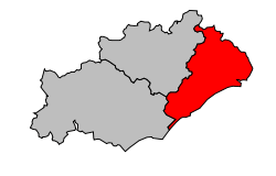
The arrondissement of Montpellier is an arrondissement of France. It is part of the Hérault département. Its INSEE code is 343 and its capital city, and prefecture of the department, is Montpellier.
It is the smallest arrondissement of the department, with an area of 1,294.6 km2 (499.8 sq mi).[1] In 2012, it has a population of 681,343 inhabitants and a density of 526.3 inhabitants/km².[2]
The main cities in the arrondissement are Montpellier (268,456 inhabitants), Sète (44,558 inhabitants), Lunel (25,405 inhabitants), Frontignan (22,728 inhabitants), Mauguio (16,7865 inhabitants), Castelnau-le-Lez (16,664 inhabitants), Lattes (15,719 inhabitants) and Mèze (10,917 inhabitants).[2]
History
When the Hérault department was created on 17 February 1800, the arrondissement of Montpellier was part of that original department.[3] In 2009 it lost the three cantons of Aniane, Ganges and Saint-Martin-de-Londres to the arrondissement of Lodève.[4]
Geography
The arrondissement covers the northeastern part of the department and is bordered to the north and northeast by the Gard department, to the east and south by the Gulf of Lyon (Mediterranean Sea), to the southwest by the arrondissement of Béziers and to the west by the arrondissement of Lodève.
Composition
Cantons
The cantons of the arrondissement of Montpellier are:
- Le Crès
- Frontignan
- Lattes
- Lodève (partly)
- Lunel
- Mauguio
- Mèze (partly)
- Montpellier-1
- Montpellier-2
- Montpellier-3
- Montpellier-4
- Montpellier-5
- Montpellier - Castelnau-le-Lez
- Pignan
- Saint-Gély-du-Fesc
- Sète
Communes
The arrondissement of Montpellier has 93 communes; they are (with their INSEE codes):
| 1. Assas (34014) | 2. Baillargues (34022) | 3. Balaruc-le-Vieux (34024) | 4. Balaruc-les-Bains (34023) |
| 5. Beaulieu (34027) | 6. Boisseron (34033) | 7. Bouzigues (34039) | 8. Buzignargues (34043) |
| 9. Campagne (34048) | 10. Candillargues (34050) | 11. Castelnau-le-Lez (34057) | 12. Castries (34058) |
| 13. Cazevieille (34066) | 14. Clapiers (34077) | 15. Claret (34078) | 16. Combaillaux (34082) |
| 17. Cournonsec (34087) | 18. Cournonterral (34088) | 19. Le Crès (34090) | 20. Fabrègues (34095) |
| 21. Ferrières-les-Verreries (34099) | 22. Fontanès (34102) | 23. Frontignan (34108) | 24. Galargues (34110) |
| 25. Garrigues (34112) | 26. Gigean (34113) | 27. Grabels (34116) | 28. La Grande-Motte (34344) |
| 29. Guzargues (34118) | 30. Jacou (34120) | 31. Juvignac (34123) | 32. Lansargues (34127) |
| 33. Lattes (34129) | 34. Lauret (34131) | 35. Lavérune (34134) | 36. Loupian (34143) |
| 37. Lunel (34145) | 38. Lunel-Viel (34146) | 39. Marsillargues (34151) | 40. Les Matelles (34153) |
| 41. Mauguio (34154) | 42. Mireval (34159) | 43. Montaud (34164) | 44. Montbazin (34165) |
| 45. Montferrier-sur-Lez (34169) | 46. Montpellier (34172) | 47. Mudaison (34176) | 48. Murles (34177) |
| 49. Murviel-lès-Montpellier (34179) | 50. Mèze (34157) | 51. Palavas-les-Flots (34192) | 52. Pignan (34202) |
| 53. Poussan (34213) | 54. Prades-le-Lez (34217) | 55. Pérols (34198) | 56. Restinclières (34227) |
| 57. Saint-Aunès (34240) | 58. Saint-Bauzille-de-Montmel (34242) | 59. Saint-Brès (34244) | 60. Saint-Christol (34246) |
| 61. Saint-Clément-de-Rivière (34247) | 62. Saint-Drézéry (34249) | 63. Saint-Geniès-des-Mourgues (34256) | 64. Saint-Georges-d'Orques (34259) |
| 65. Saint-Gély-du-Fesc (34255) | 66. Saint-Hilaire-de-Beauvoir (34263) | 67. Saint-Jean-de-Cornies (34265) | 68. Saint-Jean-de-Cuculles (34266) |
| 69. Saint-Jean-de-Védas (34270) | 70. Saint-Just (34272) | 71. Saint-Mathieu-de-Tréviers (34276) | 72. Saint-Nazaire-de-Pézan (34280) |
| 73. Saint-Sériès (34288) | 74. Saint-Vincent-de-Barbeyrargues (34290) | 75. Sainte-Croix-de-Quintillargues (34248) | 76. Saturargues (34294) |
| 77. Saussan (34295) | 78. Saussines (34296) | 79. Sauteyrargues (34297) | 80. Sussargues (34307) |
| 81. Sète (34301) | 82. Teyran (34309) | 83. Le Triadou (34314) | 84. Vacquières (34318) |
| 85. Vailhauquès (34320) | 86. Valergues (34321) | 87. Valflaunès (34322) | 88. Vendargues (34327) |
| 89. Vérargues (34330) | 90. Vic-la-Gardiole (34333) | 91. Villeneuve-lès-Maguelone (34337) | 92. Villetelle (34340) |
| 93. Villeveyrac (34341) |
References
- ↑ "Arrondissement de Montpellier (343) - Résumé statistique". Publications et statistiques pour la France ou les régions (in French). Institut national de la statistique et des études économiques - INSEE. Retrieved 6 August 2015.
- 1 2 "Populations lègales 2012 - 34-Hérault". Populations légales 2012 des départements et des collectivités d'outre-mer (in French). Institut national de la statistique et des études économiques - INSEE. Retrieved 6 August 2015.
- ↑ "Historique de l'Hérault". Le SPLAF (in French). Retrieved 6 August 2015.
- ↑ INSEE, Modifications territoriales
Coordinates: 43°36′33″N 3°52′21″E / 43.60917°N 3.87250°E