Arrondissement of Mâcon
| Mâcon | |
|---|---|
| Arrondissement of France | |
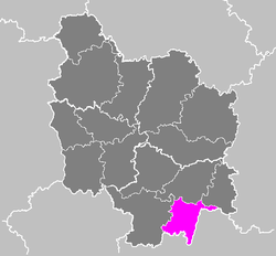 Location of Mâcon in Burgundy | |
| Country | France |
| Region | Bourgogne-Franche-Comté |
| Department | Saône-et-Loire |
| Communes | 124 |
| Prefecture | Mâcon |
| Area¹ | |
| • Total | 1,200 km2 (500 sq mi) |
| Population (2013) | |
| • Total | 113,665 |
| • Density | 95/km2 (250/sq mi) |
| ¹ French Land Register data, which exclude lakes, ponds, and glaciers larger than 1 km² as well as the estuaries of rivers. | |
The arrondissement of Mâcon is an arrondissement in the department of Saône-et-Loire, in the French region of Bourgogne-Franche-Comté. It is divided into 124 communes.
Composition
Cantons
The cantons of the arrondissement of Mâcon are:
- La Chapelle-de-Guinchay (partly)
- Cluny (partly)
- Cuiseaux (partly)
- Hurigny
- Mâcon-1
- Mâcon-2
- Tournus (partly)
Communes
The communes of the arrondissement of Mâcon, and their INSEE codes, are:
| 1. Ameugny (71007) | 2. Azé (71016) | 3. Bergesserin (71030) |
| 4. Berzé-la-Ville (71032) | 5. Berzé-le-Châtel (71031) | 6. Bissy-la-Mâconnaise (71035) |
| 7. Bissy-sous-Uxelles (71036) | 8. Blanot (71039) | 9. Bonnay (71042) |
| 10. Bourgvilain (71050) | 11. Brandon (71055) | 12. Bray (71057) |
| 13. Buffières (71065) | 14. Burgy (71066) | 15. Burnand (71067) |
| 16. Burzy (71068) | 17. Bussières (71069) | 18. Chaintré (71074) |
| 19. Chapaize (71087) | 20. Charbonnières (71099) | 21. Chardonnay (71100) |
| 22. Charnay-lès-Mâcon (71105) | 23. Chasselas (71108) | 24. Chevagny-les-Chevrières (71126) |
| 25. Chissey-lès-Mâcon (71130) | 26. Chânes (71084) | 27. Château (71112) |
| 28. Chérizet (71125) | 29. Clermain (71134) | 30. Clessé (71135) |
| 31. Cluny (71137) | 32. Cormatin (71145) | 33. Cortambert (71146) |
| 34. Cortevaix (71147) | 35. Cruzille (71156) | 36. Crêches-sur-Saône (71150) |
| 37. Curtil-sous-Buffières (71163) | 38. Curtil-sous-Burnand (71164) | 39. Davayé (71169) |
| 40. Dompierre-les-Ormes (71178) | 41. Donzy-le-National (71180) | 42. Donzy-le-Pertuis (71181) |
| 43. Farges-lès-Mâcon (71195) | 44. Flagy (71199) | 45. Fleurville (71591) |
| 46. Fuissé (71210) | 47. Germolles-sur-Grosne (71217) | 48. Grevilly (71226) |
| 49. Hurigny (71235) | 50. Igé (71236) | 51. Jalogny (71240) |
| 52. La Chapelle-de-Guinchay (71090) | 53. La Chapelle-du-Mont-de-France (71091) | 54. La Chapelle-sous-Brancion (71094) |
| 55. La Roche-Vineuse (71371) | 56. La Salle (71494) | 57. La Truchère (71549) |
| 58. La Vineuse (71582) | 59. Lacrost (71248) | 60. Laizé (71250) |
| 61. Le Villars (71576) | 62. Leynes (71258) | 63. Lournand (71264) |
| 64. Lugny (71267) | 65. Malay (71272) | 66. Martailly-lès-Brancion (71284) |
| 67. Massilly (71287) | 68. Massy (71288) | 69. Matour (71289) |
| 70. Mazille (71290) | 71. Milly-Lamartine (71299) | 72. Montagny-sur-Grosne (71304) |
| 73. Montbellet (71305) | 74. Montmelard (71316) | 75. Mâcon (71270) |
| 76. Ozenay (71338) | 77. Passy (71344) | 78. Pierreclos (71350) |
| 79. Plottes (71353) | 80. Prissé (71360) | 81. Pruzilly (71362) |
| 82. Préty (71359) | 83. Péronne (71345) | 84. Ratenelle (71366) |
| 85. Romanèche-Thorins (71372) | 86. Romenay (71373) | 87. Royer (71377) |
| 88. Sailly (71381) | 89. Saint-Albain (71383) | 90. Saint-Amour-Bellevue (71385) |
| 91. Saint-André-le-Désert (71387) | 92. Saint-Gengoux-de-Scissé (71416) | 93. Saint-Gengoux-le-National (71417) |
| 94. Saint-Huruge (71427) | 95. Saint-Léger-sous-la-Bussière (71441) | 96. Saint-Martin-Belle-Roche (71448) |
| 97. Saint-Maurice-de-Satonnay (71460) | 98. Saint-Pierre-le-Vieux (71469) | 99. Saint-Point (71470) |
| 100. Saint-Symphorien-d'Ancelles (71481) | 101. Saint-Vincent-des-Prés (71488) | 102. Saint-Vérand (71487) |
| 103. Saint-Ythaire (71492) | 104. Sainte-Cécile (71397) | 105. Salornay-sur-Guye (71495) |
| 106. Sancé (71497) | 107. Savigny-sur-Grosne (71507) | 108. Senozan (71513) |
| 109. Serrières (71518) | 110. Sigy-le-Châtel (71521) | 111. Sologny (71525) |
| 112. Solutré-Pouilly (71526) | 113. Taizé (71532) | 114. Tournus (71543) |
| 115. Tramayes (71545) | 116. Trambly (71546) | 117. Trivy (71547) |
| 118. Uchizy (71550) | 119. Varennes-lès-Mâcon (71556) | 120. Vergisson (71567) |
| 121. Verzé (71574) | 122. Vinzelles (71583) | 123. Viré (71584) |
| 124. Vitry-lès-Cluny (71587) |
External links
Coordinates: 46°18′23″N 4°49′53″E / 46.3064°N 4.8314°E
This article is issued from Wikipedia - version of the 4/25/2016. The text is available under the Creative Commons Attribution/Share Alike but additional terms may apply for the media files.