Arriach
| Arriach | ||
|---|---|---|
 | ||
| ||
 Arriach Location within Austria | ||
| Coordinates: 46°45′N 13°51′E / 46.750°N 13.850°ECoordinates: 46°45′N 13°51′E / 46.750°N 13.850°E | ||
| Country | Austria | |
| State | Carinthia | |
| District | Villach-Land | |
| Government | ||
| • Mayor | Karl-Gerfried Müller (SPÖ) | |
| Area | ||
| • Total | 70.77 km2 (27.32 sq mi) | |
| Elevation | 876 m (2,874 ft) | |
| Population (1 January 2016)[1] | ||
| • Total | 1,351 | |
| • Density | 19/km2 (49/sq mi) | |
| Time zone | CET (UTC+1) | |
| • Summer (DST) | CEST (UTC+2) | |
| Postal code | 9543 | |
| Area code | 04247 | |
| Website | www.arriach.at | |
Arriach (Slovene: Arjoh) is a municipality in the district of Villach-Land in the Austrian state of Carinthia.
Geography
It consists of the four Katastralgemeinden: Arriach, Innerteuchen, Laastadt, and Sauerwald.
Situated within the Nock Mountains range of the Central Eastern Alps, about 20 kilometres (12 miles) in the north of the city of Villach, Arriach houses the geographical centre of the state of Carinthia. The economy of the commune mainly depends on tourism.
Neighboring municipalities
| Bad Kleinkirchheim | Reichenau | Gnesau |
| Afritz am See |  |
Himmelberg |
| Treffen | Steindorf |
History
Arriach was first mentioned in a 1207 deed as Ovriach.
Religion
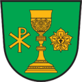
According to a 2001 census 68.8% of the population were Protestants, which is the highest percentage of all Carinthian municipalities. Therefore, the Four Evangelists parish church, erected in 1903, is the largest Protestant church building in mainly Catholic Carinthia. Furthermore, Arriach's coat of arms depicts an Eucharist chalice and a Luther rose.
A smaller Catholic church dedicated to Sts. Philipp and Jakob from about 1200 stands nearby. Arriach also features several historic rustic log homes preserved in quite good condition.
Twin town
| Wikimedia Commons has media related to Arriach. |