Nature Park of Arrábida
| Nature Park of Arrábida (Parque Natural da Arrábida) | |
| Arrábida Nature Park | |
| Nature park (Parque Natural) | |
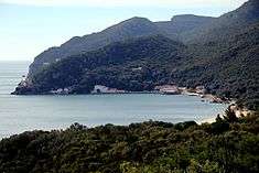
 A scenic view of the coastal part of the Nature Park of Arrábida | |
| Official name: Parque Natural da Arrábida | |
| Named for: Serra da Arrábida | |
| Nickname: Arrábida/PNArr | |
| Country | |
|---|---|
| Region | Lisbon |
| Subregion | Península de Setúbal |
| District | Setúbal |
| Municipalities | Setúbal, Palmela |
| Cities | Setúbal, Palmela |
| Location | Parque Natural da Arrábida |
| - coordinates | PT 38°29′27.2″N 8°59′44.5″W / 38.490889°N 8.995694°WCoordinates: PT 38°29′27.2″N 8°59′44.5″W / 38.490889°N 8.995694°W |
| Highest point | Formosinho |
| - location | Serra da Arrábida, Setúbal |
| - elevation | 499 m (1,637 ft) |
| - coordinates | PT 38°28′51.57″N 9°0′1.05″W / 38.4809917°N 9.0002917°W |
| Lowest point | |
| - elevation | 0 m (0 ft) |
| - coordinates | PT 38°28′49.2″N 8°58′34.7″W / 38.480333°N 8.976306°W |
| Area | 72.2 km2 (28 sq mi) |
| Biomes | Atlantic, Mediterranean |
| Geology | Schist, Quartzites, Phyllite |
| Period | Jurassic, Miocene, Pliocene, Quaternary |
| Founded | 1940 |
| Date | 16 August 1971 |
| Management | Parque Natural da Arrábida Headquarters |
| Owner | Portuguese Republic |
| For public | Public |
| Easiest access | ' |
| Wikimedia Commons: Parque Natural da Arrabida | |
| Website: Parque Natural da Arrábida | |
The Nature Park of Arrábida (Portuguese: Parque Natural da Arrabida) is a protected area, founded in 1976 and covering an area of 108 square kilometres (42 sq mi), situated between the town of Sesimbra and the city of Setúbal, the hill of Palmela and the sea, including areas in the municipalities of Setúbal, Palmela, and Sesimbra in the Portuguese Península de Setúbal region, district of Setúbal.
The chain of elevations in the park—e.g., the hills of S. Luis, Gaiteiros, S. Francisco and Louro—reach their highest peak in Serra da Arrábida (499 metres (1,637 ft)), covered in Mediterranean-like vegetation and a microclimate of which resemble Adriatic locations such as Dalmatia, and chalky in constitution where the range comes into contact with the sea.
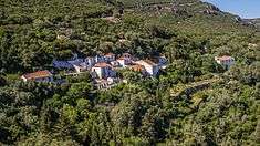
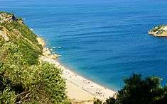
Three of the park's beaches—Galapinhos, Portinho da Arrábida and Figueirinha—are popular among the inhabitants of Lisbon and Setúbal. Overlooking the three beaches is the Convento de Nossa Senhora da Arrábida (Convent of Our Lady of Arrábida), a former monastery established in the 16th century, managed today by the Fundação Oriente.[1]
History
The particular characteristics of the Arrábida massif, resulted (since the 1940s) in various attempts to protect the region, culminating in the creation of the Arrábida Reserve (Decree 355/71) on 16 August 1971, which covered the southern flanks of the mountains and cliffs of Risco. Recognizing the insufficient protection conferred on the area, Decree 622/76 was passed on 28 July 1976, creating the Parque Natural da Arrábida (PNArr).[2] This classification envisioned the protection of the geological, forest, wildlife and landscapes, but also cultural and historical material located within the area.
Regulating decree 23/98, passed on 14 October 1998, further reclassified the nature park, expanding its coastal area and establishing the Arrábida-Espichel Marine Area, in order to support the objectives of the park, especially in the area surrounding the park. This included a diverse marine flora and fauna, such as the discontiguous zone of Cabo Espichel, which was included to protect coastal cliffs, endemic flora species, nesting areas for marine birds and preservation of rudimentary fossils.
Geography
Physical geography


The park is named for the principal geomorphological unit that covers the entire area, designated the Arrábida cordillera or massif, consisting of three subareas:[3]
- an area of small elevations in the area around Sesimbra, associated with the Serra do Risco and Serra da Arrábida, consisting of hilltops between Outão and Setúbal;
- a zone between the Serra de São Luís and the Serra dos Gaiteiros; and
- an area formed by the Serras do Louro and Serra de São Francisco.
This group is oriented east-northeast to west-southwest (alpine orientation) covering an area of about 35 kilometres (22 mi) long and 6 kilometres (3.7 mi) wide, approximately 501 metres (1,644 ft) associated with the Formosinho anticline.[3][4] Arrábida was formed from four successive phases of rifting that resulted in the fragmentation of Laurasia and the formation of the north Atlantic. This area is unique in the Atlantic for demonstrating the western propagation of the Tethys sea and the formation of the Mediterranean, caused by the collision of the African plate and the Eurasian plate, during the Late Cretaceous. Geologically, the mountainous region was created during the Jurassic and Miocene epochs, while the plains formed during the Pliocene and Quaternary periods.[5] Ribeiro (1935) indicates that the massif began to be formed with successive movements during the Tertiary era.[5]
- It is formed by three lines of dislocation, oriented more or less to the east, which succeeded a retreat from the southeast to northeast. This first area is represented by part of northern flanks of various anticlines; the second is formed by anticlines a little more inclined to the south, a third by folds and horizontal thrusts in the extreme east.
The same author (1937) indicated that the peninsula of Setúbal was, during the Mesozoic, covered by shallow seas.[5] During a great part of the Jurassic, Arrábida was a marine ecosystem covered by ocean, resulting in the formation of Dolomite limestones, today being constituted by white limestone.[5] From the Jurassic there was a movement of submersion, that formed "alternating layers of limestone, sandstone and breccia, with a clear angular unconformity on the previous limestone that ministered part of the material".[5] The sedimentary breccia is a valuable ornamental stone, more commonly known as Arrábida Marble.[5][6]
Among the notable geomorphologic points-of-interest are the Morro de Palmela, at 232 metres (761 ft), the Montes de Azeitão, that include the Serra do Louro, at 254 metres (833 ft)) and the Serra de São Francisco 257 metres (843 ft)). Parallel to the Serra do Louro, and more to the south, is the Serra de Gaiteiros, at 226 metres (741 ft), to the southwest the Serra de São Luís, at 395 metres (1,296 ft) and to the southeast the Serro do Viso at 168 metres (551 ft).[3] Along the coast is the actually Serra da Arrábida, with its highest point at 499 metres (1,637 ft) (Formosinho). Over the sea and abrupt cliffs are the Serra do Risco and Píncaro, the highest point along the Portuguese coast in this area, at approximately 380 metres (1,250 ft).[3] These mountains are constituted from limestone cliffs, with frequent rocky outcroppings forming of scenic cliffs.[3] Arrábida is dotted by karst cavities, that include the Gruta do Frade, known for singular, rarity, diversity and scenic beauty. From a paleontological perspective there are fossil deposits that include fragments of dinosaurs (normally sauropods), relevant to scientific investigation, commonly associated with the Cabo Espichel.
There are also valleys of important interest, including south of the Serra de São Francisco until Aldeia Grande, the Vale de Barris and the Vale de Alcube.[3] Between the Serra da Arrábida and the western Montes de Azeitão, is the Vale de Picheleiros, that continue from the Vale da Ribeira da Ajuda to Várzea da Comenda.[4] There is also the Vale do Solitário, between the coastal flanks of Arrábida and the Cabeços do Jaspe and Guincho, and the Vale da Vitória, in the subplateau of the Serra do Risco.[4] The coast from Sesimbra and Alpertuche is more varied and elevated then the Cabo Espichel until Sesimbra. The coast, generally elevated and abrupt, is 380 metres (1,250 ft) at the Alto do Píncaro, with rare and small beaches and coves, mostly accessible by boat.[4] From Alpertuche to Outão the coast is less elevated resulting in more beaches, such as the bay of Portinho or Chã da Anixa, a small platform only metres above the sea.[4] But, generally, the lands are inclined, principally along the north and south, but predominately along the coast.[4] Slopes in these areas of the Serra da Arrabida, Serra de Ares, Serra de Riscoa and Serra de São Luís exceed 30%, including the Vale da Rasca, Comenda, Vale do Alto da Madalena until Portela da Sardinha and areas along the north and south of the Serra de São Francisco and Serra de Louro.[4]
The waterways of Arrábida can be grouped into two principal types:
- waterways that only run during the winter months (following an irregular course whose flow increases substantially during these months); and
- perennial ravines that drain from the foothills throughout the year (with a longer, more stable course).
The hydrology is divided into two great basins: one to the northwest and north, and another to the south and east. But, the principal waterways of the park are in the east, between Setúbal, Palmela and the Vale dos Picheleiros. The ravine of Ajuda is the waterway with the greatest flow, and results from the confluence of the Ribeiras de Alcube e do Picheleiro, Ribeiras do Almelão and Ribeiras de Pomarinho. This basin includes the Vales de Picheleiro, Alcube and Ajuda, and the western and southern flanks of the Serra de São Luís, as well as the western flanks of the Nico and Viso, in addition to the Ribeira de Melra, Ribeira do Vale de Cavalo and Ribeira de Mareta. Other waterways, such as the Ribeira da Corva, affluent of the Ribeira de Livramento, or the Ribeira do Calhariz, afluente of the Rio Coina, obtain their maximum flow outside the park. Of all these waterways within the park, only the Ribeira da Ajuda conserve its flow throughout the year.
Climate

Arrábida is an accentuated Mediterranean climate divided into two seasons:
- a hot and dry summer, where temperatures hover around the temperatures of tropical regions, with periods of prolonged dry spells; and
- humid cold winters.
The proximity to the Atlantic ocean is a factor in conditioning the humidity and temperatures throughout the year. The Atlantic air masses, therefore, influence the typically Mediterranean system, diminishing the thermic amplitude and increasing atmospheric humidity from autumn to spring. The relief and exposition also influences the climatic conditions in the area, based on slopes that are primarily greater than 30%. Data from the meteorological post in Setúbal also indicates a dual period of luminosity: the first from January to August, and the second from September to December, influence the growth of vegetation.
Biome
Flora


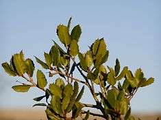
The morphology of Arrábida permits a differentiation of microhabitats of distinct characteristics (Mediterranean/Atlantic), allowing the existence of species of evergreen, deciduous or semi-deciduous trees.[3] Owing to the importance of the natural vegetation, that includes the last vestiges of varying Mediterranean vegetation, the area was included in a planning process early on, in order to save and preserve the ecosystems.[3] There are three convergent floral elements:
- Euro-Atlantic vegetation, with dominant exposures to the north, cooler humid or shaded areas;
- Mediterranean vegetation, with dominant exposures in the south, warmer, dry or luminous areas;
- Macaronesian vegetation, occupying the accidented maritime lands and arribas.
The more eastern areas, the cliffs were populated with importance species of Macaronesian flora, supporting nesting species of maritime and raptor birds protected by international convention.[3] In this area there is a lot of vegetation, that means the people want to care for the trees. Not only the people from Portugal also from the outside (people from other countries).
Fauna
In total there are 213 species of vertebrates: 8 amphibians, 16 reptiles, 154 birds, and 35 mammals.
Ecoregions/Protected areas
Arrábida concentrates a vast area of diverse vegetation, that includes 42 types and subtypes of habitats, 10 prioritized as important for conservation.
- Atlantic coast maritime dune habitat, with herbaceous vegetation (grey dunes);
- Atlantic coast maritime dune habitat, with decalcified vegetation (Calluno-Ulicetea);
- Mediterranean coastal dune habitat, with forest of Stone pine (Pinus pinea) or Maritime pine (Pinus pinaster);
- Mediterranean arborescent thickets of Bay laurel (Laurus nobilis);
- Natural meadows of rupícolas calcários or basófilos da Alysso-Sedion albi
- Semi-natural dry meadows and scrublands on limestone (Festuco-Brometalia);
- Substep grasslands and Thero-Brachypodietea annuals;
- Rocky slopes with chasmophytic vegetation and limestone slabs
- Temperate alluvial forests of Common alder (Alnus glutinosa) and European ash (Fraxinus excelsior)
- Low formations of spurge (Euphorbiaceae), that include Euphorbia pedroi
The complexity and diversity of marine habitats present in the waters of Arrábida have contributed to it being a hotspot of biodiversity, with 1400 registered species occupying the space.
Popular culture
A stretch of road in the natural park is notable for being the scene in the 1969 James Bond film On Her Majesty's Secret Service where Tracy Bond (played by Diana Rigg) is shot dead by Irma Bunt (Ilse Steppat) in a drive-by shooting at the end of the film.[7]
Arrábida is depicted in the video game Tom Clancy's Endwar as one of the theatres in World War III, when the U.S. Army invades Portugal in an attempt to weaken the European Federation's defences.
References
Notes
Sources
- ICNF, ed. (1 January 1996), Parque Natural de Arrábida (Plano de Ordenamento: 1º Fase - Estudos de Caracterização (in Portuguese), Setúbal, Portugal: Direção Regional do Ambiente e do Ordenamento do Território LVT/Institute da Conservação da Natureza e das Florestas
- Kullberg, J.C.; Pais, J.; Almeida, J.A.; Mateus, O. (2012), Contributo do património geológico e geomorfológico na candidatura da Arrábida (Portugal) a Património Mundial Misto (in Portuguese), XXXXVI Congresso Brasileiro Geologia/I Congresso Geologia Países Língua Portuguesa
- Decreto-Law n.º 622/76 (PDF) (in Portuguese), Lisbon, Portugal: Diário da República, 28 July 1976, pp. 1719–1722