Arlington Heights, Los Angeles
| Arlington Heights | |
|---|---|
| Neighborhood of Los Angeles | |
 Boundaries of Arlington Heights as drawn by the Los Angeles Times | |
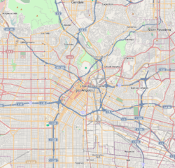 Arlington Heights Location in Central Los Angeles | |
| Coordinates: 34°02′32″N 118°19′08″W / 34.04222°N 118.31889°WCoordinates: 34°02′32″N 118°19′08″W / 34.04222°N 118.31889°W | |
| Country | United States |
| State | California |
| City | Los Angeles |
Arlington Heights is a densely populated, highly diverse neighborhood in Central Los Angeles, California, where most people live in rented homes or apartments. There are a technology center for adults, two middle schools and three other schools.
Geography
Arlington Heights is flanked by Koreatown to the north, Harvard Heights to the east, Jefferson Park to the south and Mid-City to the west. The neighborhood is bounded on the north by Olympic Boulevard, on the east by Gramercy Place, on the south by the Santa Monica Freeway and on the west by Crenshaw Boulevard.[1][2][3]
Country Club Park
Country Club Park is a historic residential area in the northwestern section of Arlington Heights, bounded by Olympic Boulevard, Crenshaw Boulevard, Pico Boulevard, and Western Avenue. [4][3] It is also a designated Los Angeles Historic Preservation Overlay Zone, with a large number of buildings dating to the earliest phases of Los Angeles’ development westwards in the 1900s to 1930s.[4]
Adjacent neighborhoods
Relation of Arlington Heights to other communities:[1][3][5]
 |
Koreatown | | ||
| Mid-City | |
Harvard Heights | ||
| ||||
| | ||||
| Jefferson Park |
Population
The 2000 U.S. census counted 22,096 residents in the 1.03-square-mile neighborhood—an average of 21,423 people per square mile, among the highest population densities in the county. In 2008, the city estimated that the population had increased to 23,330. The median age for residents was 31, about average for both the city and the county.[2]
Arlington Heights was said to be "highly diverse"[6] when compared to the city at large. The ethnic breakdown in 2000 was: Latinos, 56.6%; blacks, 24.5%; Asians, 12.9%; whites, 4.7%; and others, 1.2%. Mexico (34,9%) and El Salvador (20.2%) were the most common places of birth for the 49.8% of the residents who were born abroad, a figure that was considered high in comparison with foreign-born in the city as a whole.[2]
The median household income in 2008 dollars was $31,421, considered low for both the city and the county. The percentage of households earning $20,000 or less was high, compared to the county at large. The household size of three people was just about average for Los Angeles. Renters occupied 81.6% of the housing units, and home- or apartment owners the rest.[2]
The percentages of never-married men (42.4%) and never-married women (35.9%) were among the county's highest. The census found 1,165 families headed by single parents, the 23.5% rate being considered high for both the city and the county.[2]
Education
Arlington Heights residents aged 25 and older holding a four-year degree amounted to 13.9% of the population in 2000, about average for both the city and the county, although there was a high percentage of residents with less than a high school diploma.[2]

These are the elementary or secondary schools within the neighborhood's boundaries:[7]
- Los Angeles Technology Center, LAUSD adult education, 3721 Washington Boulevard
- Pio Pico Middle School, LAUSD, 1512 South Arlington Avenue
- Johnnie L. Cochran Jr. Middle School, LAUSD, 4066 West Johnnie Cochran Vista
- Arlington Heights Elementary School, LAUSD, 1717 Seventh Avenue
- St. Paul's Elementary School, private, 1908 South Bronson Avenue
- Saint Jeanne de Lestonnac Preschool and Kindergarten, private, 4001 Venice Boulevard
Landmarks and attractions
- Jewel's Catch One - Opened in 1973 on Pico Boulevard, a few blocks east of Crenshaw Boulevard, it was the nation's first black gay and lesbian disco.[8]
Public libraries
The neighborhood is served by the Los Angeles Public Library system. There is one branch that serves Arlington Heights.
- Washington Irving - located at 4117 West Washington Boulevard, just east of Crenshaw Boulevard.
Notable residents
- James Hanley (1847–1916), member of the Los Angeles County Board of Supervisors[9][10]
See also
- List of Registered Historic Places in Los Angeles
- List of Los Angeles Historic-Cultural Monuments in South Los Angeles
- List of districts and neighborhoods in Los Angeles
References
- 1 2 "Central L.A.," Mapping L.A., Los Angeles Times
- 1 2 3 4 5 6 "Arlington Heights," Mapping L.A., Los Angeles Times
- 1 2 3 The Thomas Guide, 2006, page 633
- 1 2 Preservation.lacity.org: Country Club Park HPOZ; with Survey Map, Adopting Ordinance, and Preservation Plan links.
- ↑ "South L.A.," Mapping L.A., Los Angeles Times
- ↑ Diversity "measures the probability that any two residents, chosen at random, would be of different ethnicities. If all residents are of the same ethnic group it's zero. If half are from one group and half from another it's .50." —Los Angeles Times
- ↑ "Arlington Heights Schools," Mapping L.A., Los Angeles Times
- ↑ http://www.latimes.com/entertainment/movies/la-et-mn-jewels-catch-one-outfest-documentary-20160606-snap-story.html
- ↑ "Former Councilman and Supervisor Hanley Dies," Los Angeles Times, April 4, 1916, page II-1
- ↑ Location of the Hanley home on Mapping L.A.
External links
- United Neighborhoods Council
- WAHA West Adams Heritage Association
- Arlington Heights crime map and statistics
| Wikimedia Commons has media related to Arlington Heights, Los Angeles. |
| Topics |  | |
|---|---|---|
| Government | ||
| Districts and neighborhoods |  | |
|---|---|---|
| Points of interest | ||