Arkansas Highway 95
| ||||
|---|---|---|---|---|
 | ||||
| Route information | ||||
| Maintained by AHTD | ||||
| Length: | 49.40 mi[1] (79.50 km) | |||
| Major junctions | ||||
| South end: |
| |||
|
| ||||
| North end: |
| |||
| Location | ||||
| Counties: | Conway, Van Buren | |||
| Highway system | ||||
| ||||

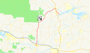
Highway 95 (AR 95, Ark. 95, and Hwy. 95) is a designation for a north–south state highway in north central Arkansas. The route runs 49.40 miles (79.50 km) runs north from US Highway 64 and Highway 113 in Morrilton north to Highway 330.[2][3]
Route description

Highway 95 begins in the Arkansas River Valley at US 64 and Highway 113 in Morrilton and runs north past the historic Morrilton Post Office, listed on National Register of Historic Places (NRHP).[4] The route runs north through a residential area before intersections with Highway 132 and Highway 95 Spur (AR 95S). North of these junctions, the highway crosses Interstate 40 (I-40) at a full interchange before becoming a rural route and passing through unincorporated areas.
In central Conway County, the highway serves as the eastern terminus of Highway 213 before beginning an concurrency with Highway 124 at Wonderview. The overlapping routes serve as the northern terminus for Highway 287 before Highway 124 departs the route at Mt. Zion. The route runs north to the edge of the Ozark National Forest before turning northeast and entering Van Buren County.[2]
The highway passes through Beverage Town, Scotland and Walnut Grove before entering Clinton. In the city, Highway 95 begins an overlap with U.S. Route 65B (US 65B) heading south. The concurrent routes pass near the Van Buren County Courthouse and Walter Patterson Filling Station, both NRHP-listed properties.[4] US 65B terminates at the parent route, and US 65/Highway 95 run south until Highway 95 splits from US 65 near the Ozark Health Medical Center. The route runs southeast to terminate at Highway 330 near Greers Ferry Lake.[3]
Major intersections
| County | Location | mi[1] | km | Destinations | Notes |
|---|---|---|---|---|---|
| Conway | Morrilton | 0.00 | 0.00 | Southern terminus | |
| 1.36 | 2.19 | AR 132 western terminus | |||
| 1.42 | 2.29 | AR 95S eastern terminus | |||
| 1.54 | 2.48 | ||||
| | 2.68 | 4.31 | AR 95S northern terminus | ||
| | 2.9 | 4.7 | AR 915 western terminus | ||
| | 8.14 | 13.10 | AR 213 southern terminus | ||
| Wonderview | 12.88 | 20.73 | Southern end of AR 124 concurrency | ||
| Blick | 16.94 | 27.26 | AR 287 northern terminus | ||
| Mt. Zion | 18.99 | 30.56 | Northern end of AR 124 concurrency | ||
| Van Buren | Clinton | 42.78 | 68.85 | Northern end of US 65B concurrency | |
| 43.33 | 69.73 | Northern end of US 65 concurrency, US 65B southern terminus | |||
| 45.38 | 73.03 | Southern end of US 65 concurrency | |||
| | 49.40 | 79.50 | Northern terminus | ||
1.000 mi = 1.609 km; 1.000 km = 0.621 mi
| |||||
Morrilton spur
| |
|---|---|
| Location: | Morrilton |
| Length: | 0.32 mi (0.51 km) |
Highway 95 Spur (AR 95S, Ark. 95S and Hwy. 95S) is a spur route in Morrilton. It is a short city street leading from the parent route to the Bosch (formerly Telex Communications) factory.
- Major intersections
The entire route is in Morrilton, Conway County.
| mi[1] | km | Destinations | Notes | ||
|---|---|---|---|---|---|
| 0.00 | 0.00 | Eastern terminus | |||
| 0.32 | 0.51 | End state maintenance, Bosch parking lot | Western terminus | ||
| 1.000 mi = 1.609 km; 1.000 km = 0.621 mi | |||||
See also
-
 Arkansas portal
 -
 U.S. Roads portal
References
- 1 2 3 Planning and Research Division (2012). "Arkansas Road Log Database" (MDB). Arkansas State Highway and Transportation Department. Retrieved May 3, 2013.
- 1 2 General Highway Map, Conway County, Arkansas (PDF) (Map). 1:62500. Cartography by Planning and Research Division. Arkansas State Highway and Transportation Department. January 2, 2008. Retrieved May 19, 2013.
- 1 2 General Highway Map, Van Buren County, Arkansas (PDF) (Map). 1:62500. Cartography by Planning and Research Division. Arkansas State Highway and Transportation Department. May 27, 2010. Retrieved May 19, 2013.
- 1 2 National Park Service (2010-07-09). "National Register Information System". National Register of Historic Places. National Park Service.