Arkansas County, Arkansas
Coordinates: 34°16′27″N 91°23′02″W / 34.27417°N 91.38389°W
| Arkansas County, Arkansas | |
|---|---|
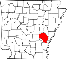 Location in the U.S. state of Arkansas | |
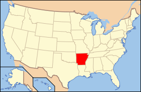 Arkansas's location in the U.S. | |
| Founded | December 13, 1813 |
| Named for | Arkansas tribe |
| Seat |
Stuttgart (north district); De Witt (south district) |
| Largest city | Stuttgart |
| Area | |
| • Total | 1,034 sq mi (2,678 km2) |
| • Land | 989 sq mi (2,561 km2) |
| • Water | 45 sq mi (117 km2), 4.4% |
| Population (est.) | |
| • (2015) | 18,433 |
| • Density | 19/sq mi (7/km²) |
| Congressional district | 1st |
| Time zone | Central: UTC-6/-5 |
Arkansas County is a county located in the U.S. state of Arkansas. As of the 2010 census, the population was 19,019.[1] The county has two county seats, De Witt and Stuttgart.[2] The first of the state's 75 present-day counties to be created, Arkansas County was formed on December 13, 1813, when this area was part of the Missouri Territory, and is named after the Arkansas Indian tribe.
Arkansas County is one of seven current-day counties in the United States to share the same name as the state they are located in (the other six counties are Hawaii County, Idaho County, Iowa County, New York County, Oklahoma County, and Utah County).[3]
Geography
According to the U.S. Census Bureau, the county has a total area of 1,034 square miles (2,680 km2), of which 989 square miles (2,560 km2) is land and 45 square miles (120 km2) (4.4%) is water.[4] It is the third-largest county in Arkansas by area.
Adjacent counties
- Prairie County (north)
- Monroe County (northeast)
- Phillips County (east)
- Desha County (south)
- Lincoln County (southwest)
- Jefferson County (west)
- Lonoke County (northwest)
National protected areas
Demographics
| Historical population | |||
|---|---|---|---|
| Census | Pop. | %± | |
| 1830 | 1,426 | — | |
| 1840 | 1,346 | −5.6% | |
| 1850 | 3,245 | 141.1% | |
| 1860 | 8,844 | 172.5% | |
| 1870 | 8,268 | −6.5% | |
| 1880 | 8,038 | −2.8% | |
| 1890 | 11,432 | 42.2% | |
| 1900 | 12,973 | 13.5% | |
| 1910 | 16,103 | 24.1% | |
| 1920 | 21,483 | 33.4% | |
| 1930 | 22,300 | 3.8% | |
| 1940 | 24,437 | 9.6% | |
| 1950 | 23,665 | −3.2% | |
| 1960 | 23,355 | −1.3% | |
| 1970 | 23,347 | 0.0% | |
| 1980 | 24,175 | 3.5% | |
| 1990 | 21,653 | −10.4% | |
| 2000 | 20,749 | −4.2% | |
| 2010 | 19,019 | −8.3% | |
| Est. 2015 | 18,433 | [5] | −3.1% |
| U.S. Decennial Census[6] 1790–1960[7] 1900–1990[8] 1990–2000[9] 2010–2015[1] | |||

As of the 2000 United States Census,[11] there were 20,749 people, 8,457 households, and 5,970 families residing in the county. The population density was 21 people per square mile (8/km²). There were 9,672 housing units at an average density of 10 per square mile (4/km²). The racial makeup of the county was 75.19% White, 23.36% Black or African American, 0.21% Native American, 0.36% Asian, 0.21% from other races, and 0.66% from two or more races. 0.76% of the population were Hispanic or Latino of any race.
There were 8,457 households out of which 31.40% had children under the age of 18 living with them, 53.00% were married couples living together, 13.90% had a female householder with no husband present, and 29.40% were non-families. 26.10% of all households were made up of individuals and 12.40% had someone living alone who was 65 years of age or older. The average household size was 2.41 and the average family size was 2.89.
In the county the population was spread out with 24.80% under the age of 18, 8.30% from 18 to 24, 26.30% from 25 to 44, 24.40% from 45 to 64, and 16.20% who were 65 years of age or older. The median age was 39 years. For every 100 females there were 90.90 males. For every 100 females age 18 and over, there were 86.00 males.
The median income for a household in the county was $30,316, and the median income for a family was $36,472. Males had a median income of $28,914 versus $21,127 for females. The per capita income for the county was $16,401. About 14.10% of families and 17.80% of the population were below the poverty line, including 24.80% of those under age 18 and 15.50% of those age 65 or over.
As of 2010 Arkansas County had a population of 19019 people. The racial makeup was 71.04% Non-Hispanic white, 24.51% black, 0.2% Native American, 0.48% Asian, 0.01% Pacific Islander, 0.06% Non-Hispanics reporting some other race, 1.18% Non-Hispanics reporting two or more races and 2.70% Hispanic or Latino.
In 2000, the largest denominational group was the Evangelical Protestants (with 10,229 adherents) and Mainline Protestants (with 3,593 adherents).[12] The largest religious bodies were The Southern Baptist Convention (with 5,103 members) and The United Methodist Church (with 2,750 members).[12]
Transportation
Major highways
 US Route 79
 US Route 165
 State Route 1
 State Route 11
 State Route 17
 State Route 33
Airports
Almyra Municipal Airport is a public-use airport located in Arkansas County. It is three nautical miles (6 km) west of the central business district of Almyra, which owns the airport.[13]
Government
| Year | GOP | DNC | Others |
|---|---|---|---|
| 2016 | 61.6% 3,825 | 31.2% 1,939 | 7.2% 447 |
| 2012 | 60.0% 3,892 | 37.8% 2,454 | 2.2% 142 |
| 2008 | 60.0% 4,185 | 37.5% 2,619 | 2.5% 174 |
| 2004 | 54.5% 3,789 | 44.8% 3,110 | 0.7% 47 |
| 2000 | 52.6% 3,353 | 45.2% 2,877 | 2.2% 142 |
Communities
Cities
Towns
Townships
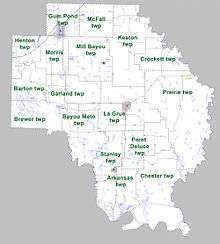
Townships in Arkansas are the divisions of a county. Each township includes unincorporated areas; some may have incorporated cities or towns within part of their boundaries. Arkansas townships have limited purposes in modern times. However, the United States Census does list Arkansas population based on townships (sometimes referred to as "county subdivisions" or "minor civil divisions"). Townships are also of value for historical purposes in terms of genealogical research. Each town or city is within one or more townships in an Arkansas county based on census maps and publications. The townships of Arkansas County are listed below; listed in parentheses are the cities, towns, and/or census-designated places that are fully or partially inside the township. [15][16]
See also
- List of lakes in Arkansas County, Arkansas
- National Register of Historic Places listings in Arkansas County, Arkansas
References
- 1 2 "State & County QuickFacts". United States Census Bureau. Retrieved May 19, 2014.
- ↑ "Find a County". National Association of Counties. Archived from the original on 2011-05-31. Retrieved 2011-06-07.
- ↑ Joseph Nathan Kane; Charles Curry Aiken (2005). The American Counties: Origins of County Names, Dates of Creation, and Population Data, 1950-2000. Scarecrow Press. ISBN 978-0-8108-5036-1.
- ↑ "2010 Census Gazetteer Files". United States Census Bureau. August 22, 2012. Retrieved August 25, 2015.
- ↑ "County Totals Dataset: Population, Population Change and Estimated Components of Population Change: April 1, 2010 to July 1, 2015". Retrieved July 2, 2016.
- ↑ "U.S. Decennial Census". United States Census Bureau. Archived from the original on May 11, 2015. Retrieved August 25, 2015.
- ↑ "Historical Census Browser". University of Virginia Library. Retrieved August 25, 2015.
- ↑ Forstall, Richard L., ed. (March 27, 1995). "Population of Counties by Decennial Census: 1900 to 1990". United States Census Bureau. Retrieved August 25, 2015.
- ↑ "Census 2000 PHC-T-4. Ranking Tables for Counties: 1990 and 2000" (PDF). United States Census Bureau. April 2, 2001. Retrieved August 25, 2015.
- ↑ Based on 2000 census data
- ↑ "American FactFinder". United States Census Bureau. Archived from the original on 2013-09-11. Retrieved 2011-05-14.
- 1 2 "County Membership Reports". thearda.com. Retrieved 2011-08-22.
- ↑ FAA Airport Master Record for M73 (Form 5010 PDF). Federal Aviation Administration. Effective 11 February 2010.
- ↑ "Dave Leip's Atlas of U.S. Presidential Elections". Retrieved November 18, 2016.
- ↑ 2011 Boundary and Annexation Survey (BAS): Arkansas County, AR (PDF) (Map). United States Census Bureau. Retrieved 2011-08-07.
- ↑ "Arkansas: 2010 Census Block Maps - County Subdivision". United States Census Bureau. Retrieved May 27, 2014.
External links
 |
Lonoke County | Prairie County | Monroe County | |
| Jefferson County | |
Phillips County | ||
| ||||
| | ||||
| Lincoln County | Desha County |
Municipalities and communities of Arkansas County, Arkansas, United States | ||
|---|---|---|
| Cities | | |
| Towns | ||
| Unincorporated communities | ||
| Footnotes | ‡This populated place also has portions in an adjacent county or counties | |