Arizona's congressional districts
Arizona is divided into 9 congressional districts, each represented by a member of the United States House of Representatives.
The districts are currently represented in the 113th United States Congress as legal entities.
Current districts and representatives
List of members of the Arizonian United States House delegation, district boundaries, and the district political ratings according to the CPVI. The delegation has a total of 9 members, with 5 Republicans, and 4 Democrats.
| District | Representative | Party | CPVI | Incumbent time in office | District map |
|---|---|---|---|---|---|
| 1st | 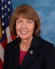 Ann Kirkpatrick (D-Flagstaff) Ann Kirkpatrick (D-Flagstaff) |
Democratic | R+4 | January 3, 2013 – present | .tif.png) |
| 2nd |  Martha McSally (R-Tucson) Martha McSally (R-Tucson) |
Republican | R+3 | January 3, 2015 – present | .tif.png) |
| 3rd |  Raúl Grijalva (D-Yuma) Raúl Grijalva (D-Yuma) |
Democratic | D+8 | January 3, 2013 – present | .tif.png) |
| 4th |  Paul Gosar (R-Prescott) Paul Gosar (R-Prescott) |
Republican | R+20 | January 3, 2013 – present | .tif.png) |
| 5th |  Matt Salmon (R-Mesa) Matt Salmon (R-Mesa) |
Republican | R+17 | January 3, 2013 – present | .tif.png) |
| 6th |  David Schweikert (R-Scottsdale) David Schweikert (R-Scottsdale) |
Republican | R+12 | January 3, 2013 – present | .tif.png) |
| 7th |  Ruben Gallego (D-Phoenix) Ruben Gallego (D-Phoenix) |
Democratic | D+16 | January 3, 2015 – present | .tif.png) |
| 8th |  Trent Franks (R-Glendale) Trent Franks (R-Glendale) |
Republican | R+15 | January 3, 2013 – present | .tif.png) |
| 9th |  Kyrsten Sinema (D-Phoenix/Mesa) Kyrsten Sinema (D-Phoenix/Mesa) |
Democratic | R+1 | January 3, 2013 – present | .tif.png) |
History
From 1863-1912, Arizona Territory sent one non-voting delegate to the House of Representatives. After its statehood in 1912, Arizona was granted one representative in the House. As the state's population has grown, Arizona's delegation has increased in size to its current total of nine representatives.
| Congress | Representatives | Notes |
|---|---|---|
| 38th - 62nd (1863–1912) |
1 | Non-voting delegate |
| 62nd - 77th (1912–1943) |
1 | |
| 78th - 80th (1943-1949) |
2 | Elected on an at-large basis |
| 81st - 87th (1949-1963) |
2 | |
| 88th - 92nd (1963-1973) |
3 | |
| 93rd - 97th (1973-1983) |
4 | |
| 98th - 102nd (1983-1993) |
5 | |
| 103rd - 107th (1993-2003) |
6 | |
| 108th - 112th (2003-2013) |
8 | |
| 113th - (2013-) |
9 |
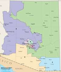
Historical and present district boundaries
Table of United States congressional district boundary maps in the State of Arizona, presented chronologically.[2] All redistricting events that took place in Arizona between 1973 and 2013 are shown.
| Year | Statewide map | Phoenix highlight |
|---|---|---|
| 1973 – 1982 | 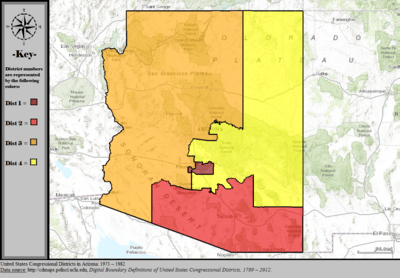 |
%2C_1973_%E2%80%93_1982.tif.png) |
| 1983 – 1992 | 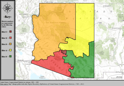 |
%2C_1983_%E2%80%93_1992.tif.png) |
| 1993 – 2002 | 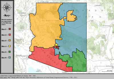 |
%2C_1993_%E2%80%93_2002.tif.png) |
| 2003 – 2013 |  |
%2C_2003_%E2%80%93_2013.tif.png) |
| Since 2013 |  |
%2C_since_2013.tif.png) |
Obsolete districts
See also
References
- ↑ "The national atlas". nationalatlas.gov. Retrieved February 22, 2014.
- ↑ "Digital Boundary Definitions of United States Congressional Districts, 1789-2012.". Retrieved October 18, 2014.