Argyle, Missouri
| Argyle, Missouri | |
|---|---|
| Village | |
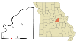 Location of Argyle, Missouri | |
| Coordinates: 38°17′40″N 92°1′28″W / 38.29444°N 92.02444°WCoordinates: 38°17′40″N 92°1′28″W / 38.29444°N 92.02444°W | |
| Country | United States |
| State | Missouri |
| Counties | Osage, Maries |
| Area[1] | |
| • Total | 0.40 sq mi (1.04 km2) |
| • Land | 0.40 sq mi (1.04 km2) |
| • Water | 0 sq mi (0 km2) |
| Elevation | 728 ft (222 m) |
| Population (2010)[2] | |
| • Total | 162 |
| • Estimate (2012[3]) | 162 |
| • Density | 405.0/sq mi (156.4/km2) |
| Time zone | Central (CST) (UTC-6) |
| • Summer (DST) | CDT (UTC-5) |
| ZIP code | 65001 |
| Area code(s) | 573 |
| FIPS code | 29-01828[4] |
| GNIS feature ID | 0729274[5] |
Argyle is a village in Maries and Osage counties in the U.S. state of Missouri. The population was 162 at the 2010 census.
The Osage County part of Argyle is part of the Jefferson City, Missouri Metropolitan Statistical Area.
History
A post office called Argyle has been in operation since 1904.[6] Argyle was named after the region of Argyll, in Scotland.[7] A variant name was "Campbell's Switch".[8]
Geography
Argyle is located at 38°17′40″N 92°01′28″W / 38.294535°N 92.024524°W (38.294535, -92.024524).[9]
According to the United States Census Bureau, the village has a total area of 0.40 square miles (1.04 km2), all of it land.[1]
Demographics
| Historical population | |||
|---|---|---|---|
| Census | Pop. | %± | |
| 1910 | 176 | — | |
| 1920 | 239 | 35.8% | |
| 1930 | 213 | −10.9% | |
| 1940 | 209 | −1.9% | |
| 1950 | 162 | −22.5% | |
| 1960 | 99 | −38.9% | |
| 1970 | 262 | 164.6% | |
| 1980 | 216 | −17.6% | |
| 1990 | 178 | −17.6% | |
| 2000 | 164 | −7.9% | |
| 2010 | 162 | −1.2% | |
| Est. 2015 | 160 | [10] | −1.2% |
2010 census
As of the census[2] of 2010, there were 162 people, 75 households, and 42 families residing in the village. The population density was 405.0 inhabitants per square mile (156.4/km2). There were 81 housing units at an average density of 202.5 per square mile (78.2/km2). The racial makeup of the village was 100.0% White. Hispanic or Latino of any race were 0.6% of the population.
There were 75 households of which 18.7% had children under the age of 18 living with them, 49.3% were married couples living together, 1.3% had a female householder with no husband present, 5.3% had a male householder with no wife present, and 44.0% were non-families. 38.7% of all households were made up of individuals and 18.6% had someone living alone who was 65 years of age or older. The average household size was 2.16 and the average family size was 2.93.
The median age in the village was 42 years. 22.2% of residents were under the age of 18; 9.4% were between the ages of 18 and 24; 20.4% were from 25 to 44; 22.8% were from 45 to 64; and 25.3% were 65 years of age or older. The gender makeup of the village was 49.4% male and 50.6% female.
2000 census
As of the census[4] of 2000, there were 164 people, 65 households, and 46 families residing in the town. The population density was 409.2 people per square mile (158.3/km2). There were 77 housing units at an average density of 192.1 per square mile (74.3/km2). The racial makeup of the town was 100.00% White.
There were 65 households out of which 35.4% had children under the age of 18 living with them, 56.9% were married couples living together, 10.8% had a female householder with no husband present, and 27.7% were non-families. 27.7% of all households were made up of individuals and 15.4% had someone living alone who was 65 years of age or older. The average household size was 2.52 and the average family size was 3.09.
In the town the population was spread out with 27.4% under the age of 18, 9.1% from 18 to 24, 26.8% from 25 to 44, 15.2% from 45 to 64, and 21.3% who were 65 years of age or older. The median age was 36 years. For every 100 females there were 78.3 males. For every 100 females age 18 and over, there were 85.9 males.
The median income for a household in the town was $23,750, and the median income for a family was $29,688. Males had a median income of $26,406 versus $22,813 for females. The per capita income for the town was $12,274. About 12.2% of families and 15.7% of the population were below the poverty line, including none of those under the age of eighteen and 17.6% of those sixty five or over.
Notable natives
- Wilbur L. Creech - Air Force general.
References
- 1 2 "US Gazetteer files 2010". United States Census Bureau. Archived from the original on 2012-01-24. Retrieved 2012-07-08.
- 1 2 "American FactFinder". United States Census Bureau. Retrieved 2012-07-08.
- ↑ "Population Estimates". United States Census Bureau. Archived from the original on 2013-06-17. Retrieved 2013-05-30.
- 1 2 "American FactFinder". United States Census Bureau. Archived from the original on 2013-09-11. Retrieved 2008-01-31.
- ↑ "US Board on Geographic Names". United States Geological Survey. 2007-10-25. Retrieved 2008-01-31.
- ↑ "Post Offices". Jim Forte Postal History. Retrieved 26 November 2016.
- ↑ Ramsay, Robert L. (1952). Our Storehouse of Missouri Place Names. University of Missouri Press. p. 29.
- ↑ "Osage County Place Names, 1928–1945". The State Historical Society of Missouri. Archived from the original on June 24, 2016. Retrieved November 26, 2016.
- ↑ "US Gazetteer files: 2010, 2000, and 1990". United States Census Bureau. 2011-02-12. Retrieved 2011-04-23.
- ↑ "Annual Estimates of the Resident Population for Incorporated Places: April 1, 2010 to July 1, 2015". Retrieved July 2, 2016.
- ↑ "Census of Population and Housing". Census.gov. Archived from the original on May 11, 2015. Retrieved June 4, 2015.
Municipalities and communities of Maries County, Missouri, United States | ||
|---|---|---|
| Cities |  | |
| Village | ||
| Townships | ||
| Unincorporated communities | ||
| Ghost town | ||
| Footnotes | ‡This populated place also has portions in an adjacent county or counties | |
Municipalities and communities of Osage County, Missouri, United States | ||
|---|---|---|
| Cities |  | |
| Villages | ||
| Townships | ||
| Unincorporated communities | ||
| Ghost towns | ||
| Footnotes | ‡This populated place also has portions in an adjacent county or counties | |