Argithea
| Argithea Αργιθέα | |
|---|---|
 | |
 Argithea | |
|
Location within the region 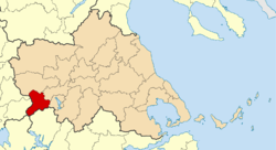 | |
| Coordinates: 39°21′N 21°32′E / 39.350°N 21.533°ECoordinates: 39°21′N 21°32′E / 39.350°N 21.533°E | |
| Country | Greece |
| Administrative region | Thessaly |
| Regional unit | Karditsa |
| Area | |
| • Municipality | 372.9 km2 (144.0 sq mi) |
| • Municipal unit | 150.4 km2 (58.1 sq mi) |
| Population (2011)[1] | |
| • Municipality | 3,450 |
| • Municipality density | 9.3/km2 (24/sq mi) |
| • Municipal unit | 1,374 |
| • Municipal unit density | 9.1/km2 (24/sq mi) |
| Community[1] | |
| • Population | 209 (2011) |
| Time zone | EET (UTC+2) |
| • Summer (DST) | EEST (UTC+3) |
| Vehicle registration | ΚΑ |
Argithea (Greek: Αργιθέα) is a village and a historic municipality in the Karditsa regional unit of Greece. The seat of the municipality is in Anthiro.[2] The name derives from King Argitheos of the Athamanians who ruled c. the 3rd to 2nd century BC
Municipality
The municipality Argithea was formed at the 2011 local government reform by the merger of the following 3 former municipalities, that became municipal units:[2]
- Acheloos
- Anatoliki Argithea
- Argithea
The municipality has an area of 372.877 km2, the municipal unit 150.377 km2.[3]
References
- 1 2 "Απογραφή Πληθυσμού - Κατοικιών 2011. ΜΟΝΙΜΟΣ Πληθυσμός" (in Greek). Hellenic Statistical Authority.
- 1 2 Kallikratis law Greece Ministry of Interior (Greek)
- ↑ "Population & housing census 2001 (incl. area and average elevation)" (PDF) (in Greek). National Statistical Service of Greece.
Administrative division of the Thessaly Region | ||
|---|---|---|
| Regional unit of Karditsa | 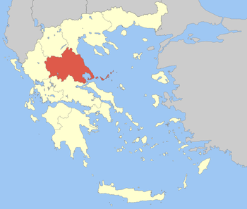 | |
| Regional unit of Larissa | ||
| Regional unit of Magnesia | ||
| Regional unit of the Sporades | ||
| Regional unit of Trikala | ||
| ||
This article is issued from Wikipedia - version of the 11/17/2016. The text is available under the Creative Commons Attribution/Share Alike but additional terms may apply for the media files.