Ardcath
| Ardcath Ard Cath | |
|---|---|
| Village | |
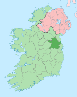
 Ardcath Location in Ireland | |
| Coordinates: 53°35′17″N 6°21′54″W / 53.588°N 6.365°WCoordinates: 53°35′17″N 6°21′54″W / 53.588°N 6.365°W | |
| Country | Ireland |
| Province | Leinster |
| County | County Meath |
| Area | |
| • Village | 43.42 km2 (16.76 sq mi) |
| Elevation | 70 m (230 ft) |
| Population (2006) | |
| • Urban | 453 |
| • Rural | 1,873 |
| Time zone | WET (UTC+0) |
| • Summer (DST) | IST (WEST) (UTC-1) |
| Irish Grid Reference | O082608 |

Ardcath (Irish: Ard Cath, meaning "height of the battle") is a hamlet in County Meath, Ireland. It is a small area inhabited by around 1,870 people which is almost a 2% decrease from the 2006 to 2002 census.[1] The surrounding areas include Garristown, Clonalvy, Duleek, Battramstown, Bellewstown and Stamullen.
History
Four Knocks (Irish: Na Fuarchnoic, meaning "Cold Hills") is a passage tomb near Ardcath that was built around 5000 years ago. The graves are decorated and show the first artistic depiction of a human face in Ireland.[2]
Ardcath is historically part of the barony of Upper Duleek. In the early 19th century half of the parish was being cultivated (principally with wheat) while the other half was pasture land. Cotton was weaved in the area for Dublin and Drogheda manufacturers.[3]
There are extensive ruins of a medieval church, surrounded by a cemetery that is still in use.
Ardcath's church was dedicated to St Mary the Blessed Virgin as was a tradition of the Norman settlement with the tithe of the Church and Parish being directed to the Canons of Llananthony (prima and secunda) Wales from 1172 to 1541. The church also had an active 'confraternity' which was a body corporate dedicated to maintaining religious services within the Church. Such organisations were often established by Charter and survived the Reformation. There was a similar organisation at the Church in the then adjoining parish of Piercetown.
Community
There are several community groups in the area such as the Ardcath Macra and a guild of the Irish Countrywomen's Association - these have been around since 1952 and 1948 respectively and often include members of the surrounding towns.[4][5]
Ardcath has a local school that was built in 1950 and is currently attended by around 100 students. Prior to this the school was in the old Ardcath Penal Day Church building when it stopped being used in 1862.[6]
Every year there is a large festival organised by the Ardcath Parish Committee. The festival runs the course of a week in summer and every second year the Rose of Ardcath is contested in the local pub, Bennet's.[7] The building was originally built in 1859. The building is use for religious worship and is a single storey detached building. It was built because of the deteriorating condition of the old church built in 1690. The church cost 2600 pounds. Due to poor architect it suffered storm damage regularly. In 1903 the sacristy roof was stripped and the nave damaged. The roof was stripped and re-slated in 1992. The building is gothic style. In 1955 extensive renovation work was carried out on the church. The walls and floors were repaired and a sacred heart altar with marble rails was erected. There has reasonably been renovation work done on the church with the walls and windows.
Transportation
The roads in Ardcath are all local roads - though there are some regional roads close by such as the R130 in Garristown. Safety concerns over the state of some of the roads around Ardcath have been raised at the meeting of the Slane Electoral Area Committee of Meath County Council,[8] including concerns relating to inadequate signage notifying drivers on the approach to the local school.[9]
See also
External links
References
- ↑ 2006 Preliminary Report Archived 24 March 2009 at the Wayback Machine.
- ↑ Meath Tourism - Four Knocks
- ↑ Lewis Topographical Dictionary Archived 4 July 2008 at the Wayback Machine.
- ↑ Ardcath Macra History Archived 26 July 2009 at the Wayback Machine.
- ↑ ICA-Ardcath's 60th Anniversary
- ↑ Ardcath cemetery inscriptions and information Archived 20 July 2008 at the Wayback Machine.
- ↑ Drogheda Independent - Full Swing Festival
- ↑ East Meath issues aired as Slane area council meets Archived 21 July 2011 at the Wayback Machine.
- ↑ Ardcath and Clonalvy Action Group Archived 16 July 2008 at the Wayback Machine.