Microregion of Aragarças
| Aragarças |
|---|
|
Microregion |
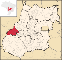
Location in Goias state |
| Country |
Brazil |
|---|
| State |
Goiás |
|---|
| Mesoregion |
Noroeste Goiano |
|---|
| Municipalities |
7 |
|---|
| Area |
|---|
| • Total |
11,091.90 km2 (4,282.61 sq mi) |
|---|
| Population (2007) |
|---|
| • Total |
53,541 |
|---|
| • Density |
4.8/km2 (13/sq mi) |
|---|
The Aragarças Microregion is a geographical division in Goiás state, Brazil. It consists of 7 municipalities located around Aragarças in western Goiás.
Municipalities
The microregion consists of the following municipalities:[1]
| Name | Population | Area in km2 |
| Aragarças | 17,156 | 660 |
| Arenópolis | 3,495 | 3,495 |
| Baliza | 3,299 | 1,789 |
| Bom Jardim de Goiás | 8,372 | 1,557 |
| Diorama | 2,236 | 687 |
| Montes Claros de Goiás | 7,844 | 2,899 |
| Piranhas | 11,139 | 2,047 |
| Total | 53,541 | 11,092 |
The most populous municipality is Aragarças with 17,156 inhabitants and the least populous is Diorama with 2,236 inhabitants. The largest municipality in area is Montes Claros de Goiás with 2,909.4 km² and the smallest is Diorama with 689.6 km².
See also
References
|
|---|
|
|
|
| Mesoregion Centro Goiano |
|---|
| Anapolis | |
|---|
| Anicuns | |
|---|
| Ceres | |
|---|
| Goiania | |
|---|
| Ipora | |
|---|
|
| |
|
| Mesoregion Leste Goiano |
|---|
| Entorno de Brasilia | |
|---|
| Vao do Parana | |
|---|
|
|
|
| Mesoregion Noroeste Goiano |
|---|
| Aragarcas | |
|---|
| Rio Vermelho | |
|---|
| Sao Miguel do Araguaia | |
|---|
|
|
|
| Mesoregion Norte Goiano |
|---|
| Chapada dos Veadeiros | |
|---|
| Porangatu | |
|---|
|
|
|
| Mesoregion Sul Goiano |
|---|
| Catalao | |
|---|
| Meia Ponte | |
|---|
| Pires do Rio | |
|---|
| Quirinopolis | |
|---|
| Sudoeste de Goias | |
|---|
| Vale do Rio dos Bois | |
|---|
|
|
Coordinates: 15°53′52″S 52°15′03″W / 15.89778°S 52.25083°W / -15.89778; -52.25083
