Apolima Strait

The Apolima Strait is about 13 km[1] wide and separates the two largest islands of Samoa, the island of Savai'i to the northwest, and Upolu to the southeast.
Three small islands lie in the strait, Manono and Apolima, which have small village settlements and tiny uninhabited islet Nu'ulopa.[2]
Manono is about 3 miles off the west coast of Upolu and Apolima lies approximately near the middle of the strait. Nu'ulopa is a tiny rocky outcrop with palm trees and surrounded by a natural turtle habitat.
The main means of transport between the two large islands, passenger and vehicle ferries operated by the Samoa government, run through the strait between Mulifanua wharf on Upolu and Salelologa wharf on Savai'i.
The ferry crossing takes about 90-minutes.
Gallery
- Apolima Strait
-
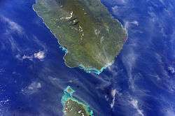
Apolima Strait with Savai'i (top) and the tip of Upolu below.
-
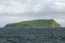
Apolima island.
-

Heading by boat towards uninhabited Nu'ulopa island (left) with Apolima island (right)
-

Map of Samoa showing Apolima Strait between Upolu (right) and Savai'i (left).
See also
References
- ↑ "Apolima". Oceandots. Archived from the original on December 23, 2010. Retrieved 31 January 2010.
- ↑ Rottman, Gordon L (2002). World War 2 Pacific island guide. Greenwood Publishing Group. p. 88. ISBN 0-313-31395-4. Retrieved 27 January 2010.
Coordinates: 13°49′08″S 172°10′19″W / 13.819°S 172.172°W