Aotea Lagoon
| Aotea Lagoon | |
|---|---|
.jpg) A view from the north-east: Pipitea miniature railway station across the lagoon, State Highway 1, North Island Main Trunk Railway and Porirua Harbour to the right. | |
| Location | North Island |
| Coordinates | 41°7′12″S 174°51′25″E / 41.12000°S 174.85694°ECoordinates: 41°7′12″S 174°51′25″E / 41.12000°S 174.85694°E |
| Type | artificial lagoon |
| Primary inflows | Porirua Harbour and stormwater drains |
| Primary outflows | Porirua Harbour |
| Basin countries | New Zealand |
| Surface area | 5 ha (12 acres)[1] |
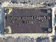
| Shore length1 | 732 m (2,402 ft) |
| Surface elevation | sea level |
| Settlements | Papakowhai [1] |
| 1 Shore length is not a well-defined measure. | |
Aotea Lagoon is an artificial lagoon surrounded by a 7-hectare (17-acre) public park in the Papakowhai suburb of Porirua, North Island, New Zealand.[1] Aotea and two nearby lagoons were created as transport links were realigned from the natural coastline to land reclaimed from Porirua Harbour.
Hydrology
The lagoon is 5 hectares (12 acres) of seawater,[1] connected to Porirua Harbour by a culvert under the model windmill.[2] Three stormwater drains empty into the lagoon,[3] two in the east bank, the third in the south-east under the jetty.
The lagoon's "water body receives limited flushing and aeration" and "little can be done to improve water quality without extensive engineering works."[3] Poor water quality means swimming is prohibited.[4]
History
The North Island Main Trunk railway and State Highway 1 used to run round three bays between Porirua and Paremata. In 1961 the railway was realigned to a causeway built between headlands at the mouth of Porirua Stream, Gear Homestead, present day Thurso Grove and Forth Place.[5] Cut off from the sea, the bays became lagoons. The lagoons were partly filled in, with material from the Ministry of Works and Development's local earthworks,[6] then the highway was realigned inland of the railway.
The Ministry, Porirua City Council, Project Employment Programme and local service clubs turned the area around the middle lagoon into a public park,[2] that opened as Aotea Lagoon in 1980.[7] Originally leased from the Crown, the park was taken over by the City Council in 1994.[2]
Facilities
The park's centrepiece is a path around the lagoon, the easiest of Porirua's top 12 walking and cycling tracks.[8]
The Waitangirua Lions built a ¼ scale ridable miniature railway with an 833-metre (2,733 ft) loop track including two bridges and a tunnel.[9] The train runs Sunday afternoon, weather permitting, from Pipitea Station south-west of the lagoon.[10]
The park has lawns on three sides, some with barbecues. Other facilities from the north-east are adventure and toddlers' playgrounds, a duck pond crossed by boardwalk, an island reached by bridge and a Pétanque terrain. In the south-west corner are another duck pond, a fernery and a rose garden.
Most people visit Aotea Lagoon for exercise or relaxation while children enjoy the playgrounds, feeding the ducks, riding bicycles and the train.[11]
Notes
- 1 2 3 4 Porirua City Council (1994), p.1.
- 1 2 3 Porirua City Council (1994), p.7.
- 1 2 Porirua City Council (1994), p.40.
- ↑ Porirua City Council (1994), p.38.
- ↑ Porirua City Council (1994), p.4.
- ↑ Porirua City Council (1994), p.6.
- ↑ Porirua City Council, Historic Site: Aotea Lagoon.
- ↑ Porirua City Council, Porirua's Top 12 Walking and Cycling Tracks.
- ↑ Canterbury Society of Model and Experimental Engineers (2002), p.2.
- ↑ Waitangirua Lions Club, The Aotea Lagoon Train.
- ↑ Jacobson (2009), p.2.
References
- Porirua City Council (1994). "Aotea Lagoon Management Plan" (PDF). Porirua City Council. Retrieved 2015-12-23.
- Porirua City Council. "Historic site: Aotea Lagoon". Porirua City Council. Retrieved 2015-12-23. Includes photographs of the railway causeway and Aotea Lagoon being built.
- Porirua City Council. "Porirua's Top 12 Walking and Cycling Tracks". Porirua City Council. Retrieved 2015-12-23.
- Canterbury Society of Model and Experimental Engineers (2002). "Mini Railways in New Zealand, 2nd Edition" (PDF). Archived from the original (PDF) on May 26, 2010. Retrieved 2015-12-23.
- Waitangirua Lions Club. "The Aotea Lagoon Train". Waitangirua Lions Club. Retrieved 2015-12-23.
- Jacobson, Christine (2009). "Aotea Lagoon Visitor Monitoring 2009" (PDF). Porirua City Council. Retrieved 2015-12-23.