Aopo
| Aopo | |
|---|---|
| Village & Sub-district | |
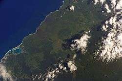 | |
| Satellite image of Savai'i north west with Asau harbour, lava fields and Aopo inland. (NASA photo, 2002) | |
 Aopo | |
| Coordinates: 13°29′S 172°30′W / 13.483°S 172.500°W | |
| Country |
|
| District | Gaga'ifomauga |
| Population (2006) | |
| • Total | 340 |
| Time zone | -11 |
Aopo is a village on the island of Savai'i in Samoa. It is in the political district of Gaga'ifomauga.
The village is located inland from the north coast of Savai'i, close to the main lava field from the island's volcanic cones. There is an Aopo Conservation Area open to visitors and the trail starts at the east end of the village.
Hikers can ascend Mt Silisili, Samoa's highest peak, from Aopo.[1]
In 2007, Aopo village sold its teak plantation to Blue Bird Lumber.[2]
See also
- Culture of Samoa
- Fa'amatai, chiefly system of governance in the Samoa Islands
- Samoan language
- Samoans
References
- ↑ Tonga-Samoa handbook by David Stanley, p.151
- ↑ Samoa Forestry Outlook Study by Sam Sesega, p.14, Working Paper No. APFSOS II/WP/2009/01,Food and Agriculture Organization of the United Nations Regional Office for Asia and the Pacific.
External links
Traditional center: Safotu | ||
| Villages |  | |
| Notable landmarks | ||
| Conservation & Environment | ||
| Education & Schools | ||
| Electoral constituencies: Faipule Districts |
| |
Coordinates: 13°29′S 172°30′W / 13.483°S 172.500°W
This article is issued from Wikipedia - version of the 10/29/2016. The text is available under the Creative Commons Attribution/Share Alike but additional terms may apply for the media files.