Anuradhapura
| Anuradhapura අනුරාධපුරය அனுராதபுரம் | |
|---|---|
| City | |
|
| |
 Anuradhapura Location in Sri Lanka | |
| Coordinates: 8°21′0″N 80°23′7″E / 8.35000°N 80.38528°ECoordinates: 8°21′0″N 80°23′7″E / 8.35000°N 80.38528°E | |
| Country | Sri Lanka |
| Province | North Central Province |
| District | Anuradhapura |
| Established | 4th century BC |
| Government | |
| • Type | Municipal Council |
| Area | |
| • City | 7,179 km2 (2,772 sq mi) |
| • Urban | 36 km2 (14 sq mi) |
| Elevation | 81 m (266 ft) |
| Population (2012) | |
| • City | 50,595 |
| • Density | 2,314/km2 (5,990/sq mi) |
| Demonym(s) | Anuradhians |
| Time zone | Sri Lanka Standard Time Zone (UTC+5:30) |
| Postal code | 50000 |
Anuradhapura (Sinhalese: අනුරාධපුරය ; Tamil: அனுராதபுரம்) is a major city in Sri Lanka. It is the capital city of North Central Province, Sri Lanka and the capital of Anuradhapura District. Anuradhapura is one of the ancient capitals of Sri Lanka, famous for its well-preserved ruins of an ancient Sri Lankan civilization. It was the third capital of the Kingdom of Rajarata, following the kingdoms of Tambapanni and Upatissa Nuwara.
The city, now a UNESCO World Heritage Site, was the center of Theravada Buddhism for many centuries. The city lies 205 km (127 mi) north of the current capital Colombo in Sri Lanka's North Central Province, on the banks of the historic Malvathu Oya. It is one of the oldest continuously inhabited cities in the world and one of the eight World Heritage Sites of Sri Lanka.
It is believed that from the fourth century BC until the beginning of the 11th century AD it was the capital of the Sinhalese. During this period it remained one of the most stable and durable centers of political power and urban life in South Asia. The ancient city, considered sacred to the Buddhist world, is today surrounded by monasteries covering an area of over sixteen square miles (40 km²).
Urban Area
- Protohistoric Iron Age
Although according to historical records the city was founded in the 5th century BC, the archaeological data put the date as far back as the 10th century BC.[1] Very little evidence was available about the period before the 5th century BC (i.e. the protohistoric period), though excavations have revealed information about the earlier inhabitants of the city.
Further excavations in Anuradhapura have uncovered information about the existence of a protohistoric habitation of humans in the citadel. The protohistoric Iron Age, which spans from 900 to 600 BC, marked the appearance of iron technology, pottery, the horse, domestic cattle and paddy cultivation. In the time period 700 to 600 BC, the settlement in Anuradhapura had grown over an area of at least 50 hectares (120 acres). The city was strategically situated of major ports northwest and northeast. It was surrounded by irrigable and fertile land. The city was also buried deep in the jungle providing natural defence from invaders.
- Lower Early Historic period
The Lower Early Historic period, spanning from 500 to 250 BC, is studied on the lines of the chronicles. During this time King Pandukabhaya formally planned the city, with gates, quarters for traders etc. The city at the time would have covered an area of 1 square kilometre which makes it one of the largest in the continent at the time.
Beginnings
| Sacred City of Anuradhapura | |
|---|---|
| Name as inscribed on the World Heritage List | |
| Type | Cultural |
| Criteria | ii, iii, vi |
| Reference | 200 |
| UNESCO region | Asia-Pacific |
| Inscription history | |
| Inscription | 1982 (6th Session) |
The layout of Anuradhapura as described in the Mahavamsa:
- He laid out four suburbs as well as the Abhaya-tank, the common cemetery, the place of execution, and the chapel of the Queens of the West, the banyan-tree of Vessavana and the Palmyra-palm of the Demon of Maladies, the ground set apart for the Yonas and the house of the Great Sacrifice; all these he laid out near the west gate.[2]
- A hermitage was made for many ascetics; eastward of that same cemetery, the ruler built a house for the Nigantha Jotiya. On the further side of Jotiya's house and on this side of the Gamani tank, he likewise built a monastery for wandering mendicant monks, and a dwelling for the Ajivakas and a residence for the Brahmans, and in this place and that he built a lying-in shelter and a hall for those recovering from sickness.[2]
It is believed that King Pandukabhaya made it his capital in the 4th century BC, and that he also laid out the town and its suburbs according to a well-organized plan. He constructed a reservoir named Abhayavapi. He established shrines for yakkhas such as Kalawela and Cittaraja. He housed the Yaksini-Cetiya in the form of a mare within the royal precincts, and offerings were made to all these demi-gods every year. He chose the sites for the cemetery and for the place of execution, the Chapel of the Western Queen, the Pacchimarajini, the Vessavana Banyan Tree, the Palm of the Vyadhadeva, the Yona Quarter and the House of the Great Sacrifice. The slaves or Candalas were assigned their duties, and a village was set apart for them. They build dwellings for Niganthas, for wandering ascetics and for Ajivakas and Brahmanas. He established, the village boundaries. The tradition that King Pandukabhaya made Anuradhapura the capital city of Sri Lanka as early as the 4th century BC had been very important.
The administrative and sanitary arrangements made for the city and the shrines he provided indicate that over the years, the city developed according to an original master plan. His son, Mutasiva, succeeded to the throne. During his reign of sixty years, he maintained Anuradhapura as his capital and further laid out the Mahameghavana Garden which was to play an important role in the early history of Buddhism in Sri Lanka. It was in the period of his successor, his son Devanampiya Tissa, that Buddhism was first introduced to this island 236 years after the passing away of the Buddha. Emperor Ashoka of India was a contemporary of Devanampiya Tissa.
Mahinda was the son of Emperor Ashoka of India. Ashoka embraced Buddhism after he was inspired by a very small monk named Nigrodha. The king, who was in great misery after seeing the loss of life caused by his waging wars to expand his empire, was struck by the peaceful countenance of such a young monk. Meeting this young monk made a turning point in his life and he thereafter, renounced wars. He was determined to spread the message of peace, to neutralize the effects from the damages caused by him through his warfare. As a result, both his son and daughter were ordained as Buddha disciples, and became enlightened as Arahats. In his quest to spread the message of peace instead of war, he sent his son Mahinda, to the island of Lanka, which was also known as “Sinhalé”. According to Dipavamsa and Mahavamsa, Thera Mahinda came to Sri Lanka from India on the full moon day of the month of Poson (June) and met King Devanampiyatissa and the people, and preached the doctrine.
Historically this period is believed to extend from 250 to 210 BC. This is the point at which a kingship began and a civilization developed based on one of the most significant religions of South Asia, Buddhism.
Buddhism and Anuradhapura
With the introduction of Buddhism, the city gained more prominence and the great building era began. The Mahavansa states that King Kutakannatissa built the first city wall to a height of seven cubits with a moat in front of the wall. This fortification was further enlarged by raising the wall a further 11 cubits to 18 cubits by King Vasabha. The king also added fortified gatehouses at the entrances of which the ruins can be seen to date. The Mahavamsa also states that soothsayers and architects were consulted in the construction.
During the late Anuradhapura period, the royal family and nobility of Sri Lanka strongly supported Buddhism. As such, they frequently commissioned works of art and donated these items to Buddhist temples. In return, the temple and local Buddhist community supported the king's rule. Art works featuring depictions of Avalokitesvara, the Bodhisattva of Mercy and Compassion, became increasing popular.[3]
The city grows
The city's popularity grew both as a ritual centre and as the administrative centre, a large population was attracted to the city for permanent settlement. Thus the living facilities were improved to accommodate the expanding population. King Vasabha constructed many ponds which were fed by a network of subterranean channels which were constructed to supply water to the city. The Tissa and Abhayavapi tanks were built, the Nuwara weva was built and the Malwatu Oya was dammed to build the Nachchaduwa wewa which was 4,408 acres (17.84 km2) in size.
Parks were also provided in the city. The Ranmasu Uyana below the bund of Tissavapi or Tissa weva was one such, but it was strictly reserved for the members of the royal family. Health care and education were two other aspects to which the authorities paid attention. There were several hospitals in the city. In the 4th century King Upatissa II provided quarters and homes for the crippled and the blind. King Buddhadasa (337-365 AD), himself a physician of great repute, appointed a physician to be in charge of every ten villages. For the maintenance of these physicians, one tenth of the income from the fields was set apart. He also set up refuges for the sick in every village. Physicians were also appointed to look after the animals. Kassapa V (914-923 AD) founded a hospital close to the southern gate of Anuradhapura. General Sena in the 10th century is believed to have built a hospital close to the ceremonial street (Managala Veediya). The history of medical care began early, for in the 4th century BC King Pandukhabaya, in the course of sanitizing the town constructed a hospital. A large workforce was entrusted with the task of keeping the city clean.
Large lakes were also constructed by the city's rulers to irrigate paddy lands and also to supply water to the city. Nuwara wewa and Tissa wewa are among the best known lakes in the city.
The Great City
Anuradhapura attained its highest magnificence about the commencement of the common era. The city had some of the most complex irrigation systems of the ancient world, situated in the dry zone of the country the administration built many tanks to irrigate the land. Most of these tanks still survive.
Modern era
European discovery
The area was uninhabited for many centuries, but the local population remained aware of the ruins. In Robert Knox's 1681 An Historical Relation of the Island Ceylon, he wrote: "At this City of Anurodgburro is a Watch kept, beyond which are no more people that yield obedience to the King of Candy".[4] In 1821, John Davy wrote that: "Anooradapoora, so long the capital of Ceylon, is now a small mean village, in the midst of a desert. A large tank, numerous stone pillars, two or three immense tumuli, (probably old dagobahs,) are its principal remains. It is still considered a sacred spot; and is a place of pilgrimage."[5]
Excavations
Various excavations have taken place at the site, beginning in 1884-86 by Stephen Montagu Burrows.[6]
According to carbon dating, the ruins excavated were from the 10th century BC.
Ruins

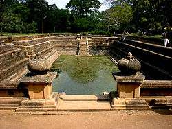
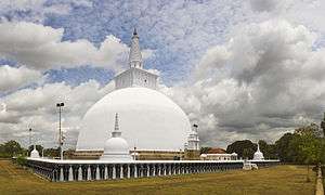
The ruins consist of three classes of buildings, dagobas, monastic buildings, and pokunas. The dagobas are bell-shaped masses of masonry, varying from a few feet to over 1100 ft (340 m) in circumference. Some of them contain enough masonry to build a town for twenty-five thousand inhabitants. Remains of the monastic buildings are to be found in every direction in the shape of raised stone platforms, foundations and stone pillars. The most famous is the Brazen Palace erected by King Dutugamunu about 164 BC. The pokunas are bathing-tanks or tanks for the supply of drinking water, which are scattered everywhere through the jungle. The city also contains a sacred Bo-Tree, which is said to date back to the year 245 BC.
Eight Great Places of Veneration in Anuradhapura - Atamasthana
- Jaya Sri Maha Bodhi
- Ruwanwelisaya
- Thuparamaya
- Lovamahapaya
- Abhayagiri Dagaba
- Jetavanarama
- Mirisaveti Stupa
- Lankarama
Other structures

- Isurumuniya
- Magul Uyana
- Vessagiri
- Rathna Prasadaya
- Queen's Palace
- Dakkhina Stupa
- Sela Cetiya
- Naka Vihara
- Kiribath Vehera
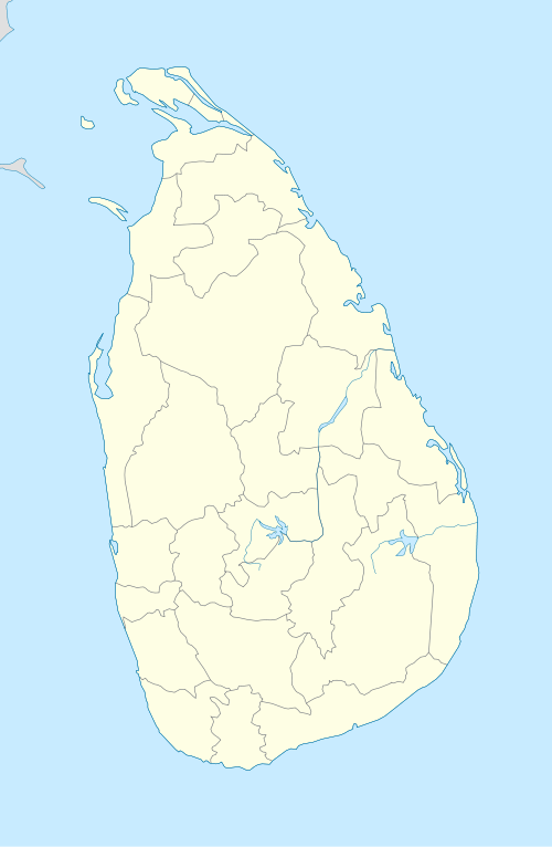
- Kuttam Pokuna
- Samadhi Statue
- Toluwila Statue
- Ranmasu Uyana
Demographics
| Ethnicity | Population | % Of Total |
|---|---|---|
| Sinhalese | 51,775 | 91.42 |
| Sri Lankan Moors | 3,825 | 6.75 |
| Sri Lankan Tamils | 850 | 1.50 |
| Indian Tamils | 45 | 0.08 |
| Other (including Burgher, Malay) | 137 | 0.24 |
| Total | 56,632 | 100 |
Source: www.statistics.gov.lk - Census 2001
Transportation
Anuradhapura is served by railway and highways. The Northern railway line connects Anuradhapura with Colombo, Jaffna, and Kankesanthurai. Anuradhapura railway station is the city's rail gateway, with major services, such as the Yal Devi, calling there. Anuradhapura is a central city of Sri Lanka. It is directly connected to a large number of major cities and towns of the island. By road, it is connected to Vavuniya, Dambulla, Puttalam, Trincomalee, Jaffna, Kurunegala and Kandy. Due to its status as a crossroads city, the city is a good base for exploring many important ancient landmarks a short distance away.
Picture gallery
-
The Ruwanweli Saya dagoba in Anuradhapura
-

Anuradhapura is famous for its well-preserved ruins of ancient Sri Lankan civilization
-
Jaya Sri Maha Bodhi Anuradhapura
-

A Moonstone from Anuradhapura
-
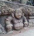
A vamana sculpture from Anuradhapura

References
- ↑ Deraniyagala, SU. The Prehistory of Sri Lanka, Vol II, Department of Archaeological Survey, Colombo: 1992. p435.
- 1 2 Mahavamsa X, trans. Wilhelm Geiger
- ↑ Birmingham Museum of Art (2010). Birmingham Museum of Art : guide to the collection. [Birmingham, Ala]: Birmingham Museum of Art. p. 57. ISBN 978-1-904832-77-5.
- ↑ Robert Knox (1681), Historical Relation chapter 2, full quote "There are besides these already mentioned, several other ruinous places that do still retain the name of Cities, where Kings have Reigned, tho now little Foot steps remaining of them. At the North end of this Kings Dominions is one of these Ruinous Cities, called Anurodgburro, where they say Ninety Kings have Reigned, the Spirits of whom they hold now to be Saints in Glory, having merited it by making Pagoda’s and Stone Pillars and Images to the honour of their Gods, whereof there are many yet remaining: which the Chingulayes count very meritorious to worship, and the next way to Heaven. Near by is a River, by which we came when we made our escape: all along which is abundance of hewed stones, some long for Pillars, some broad for paving. Over this River there have been three Stone Bridges built upon Stone Pillars, but now are fallen down; and the Countrey all desolate without Inhabitants. At this City of Anurodgburro is a Watch kept, beyond which are no more people that yield obedience to the King of Candy. This place is above Ninety miles to the Northward of the City of Candy. In these Northern Parts there are no Hills, nor but two or three Springs of running water, so that their Corn ripeneth with the help of Rain."
- ↑ John Davy (1821), An Account, full quote: "Anooradapoora, so long the capital of Ceylon, is now a small mean village, in the midst of a desert. A large tank, numerous stone pillars, two or three immense tumuli, (probably old dagobahs,) are its principal remains. It is still considered a sacred spot; and is a place of pilgrimage. This information was collected partly from the natives, and partly from an officer who visited it during the rebellion."
- ↑ Department of Archaeology - Sri Lanka: "The first methodical excavation of the Department of Archaeology had been carried out by Mr. S.M. Burrows in Anuradhapura and Polonnaruwa during 1884 to 1886. Subsequently, the exploration and excavation activities were undertaken mainly in Anuradhapura and Sigiriya with the guidance of Mr. H.C.P. Bell in 1890. Similarly archaeological excavations in Anuradhapura and other areas of the island were carried out under the supervision of Mr. E.M. Ayrton (1912-1914) and Mr. Raja De Silva (1983). Mr. E.M. Hocart who was appointed as the Commissioner of Archaeology in Sri Lanka in 1926, carried out excavations using the method of stratification, in places such as Mathota, Pomparippu, Anuradhapura inner city and Ambalantota."
- Harischandra, B. W.: The Sacred City of Anuradhapura, Reprint. New Delhi, Asian Educational Services, 1998.
- Nissanka, H.S.S.: Maha Bodhi Tree in Anuradhapura, Sri Lanka : The Oldest Historical Tree in the World, New Delhi 1996, (Reprint. Vikas)
- R. A. E. Coningham.: The Origins of the Brahmi Script Reconsidered: The New Evidence from Anuradhapura, Minerva 8(2): 27-31, 1995.
- R. A. E. Coningham.: Anuradhapura Citadel Archaeological Project: Preliminary Results of a Season of Geophysical Survey. South Asian Studies 10: 179-188, 1994.
- A. Seneviratne.: Ancient Anuradhapura The Monastic City, Archaeological Department of Sri Lanka. p. 310, 1994.
- S. M. Burrows, The Buried Cities of Ceylon - A Guide Book to Anuradhapura and Polonaruwa Reprint, p. 120, 1999.
External links
| Wikimedia Commons has media related to Anuradhapura. |
| Wikivoyage has a travel guide for Anuradhapura. |
| Wikisource has the text of the 1911 Encyclopædia Britannica article Anuradhapura. |
- UNESCO World Heritage List - Sacred City of Anuradhapura
- Anuradhapura Case-Study by students of School of Planning & Architecture
- Sacred City of Anuradhapura
| National capitals# |
| |
|---|---|---|
| Municipal councils | ||
| Urban councils |
| |
Note: * also a Provincial capital, # also a Municipal council | ||
Provincial capitals of Sri Lanka | ||
|---|---|---|
| ||