Ant Flat Ranger Station
|
Ant Flat Ranger Station | |
|
USFS photo, 1935 | |
  | |
| Location | United States Forest Service Road 36, 2 miles south of Fortine in the Kootenai National Forest |
|---|---|
| Coordinates | 48°43′26″N 114°52′35″W / 48.72389°N 114.87639°WCoordinates: 48°43′26″N 114°52′35″W / 48.72389°N 114.87639°W |
| Architectural style | log style |
| NRHP Reference # | 94001021 |
| Added to NRHP | December 30, 1996[1] |
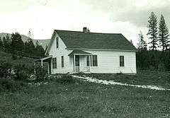
The Ant Flat Ranger Station is a site on the National Register of Historic Places located 2 miles south of Fortine, Montana in Kootenai National Forest. It was added to the Register on December 30, 1996.
References
- ↑ National Park Service (2010-07-09). "National Register Information System". National Register of Historic Places. National Park Service.
| Topics | |
|---|---|
| Lists by states |
|
| Lists by insular areas | |
| Lists by associated states | |
| Other areas | |
| |
This article is issued from Wikipedia - version of the 11/29/2016. The text is available under the Creative Commons Attribution/Share Alike but additional terms may apply for the media files.