Angat, Bulacan
| Angat | ||
|---|---|---|
| Municipality | ||
|
Angat Public Market (Poblacion) | ||
| ||
 Map of Bulacan showing the location of Angat | ||
.svg.png) Angat Location within the Philippines | ||
| Coordinates: 14°55′N 121°03′E / 14.92°N 121.05°ECoordinates: 14°55′N 121°03′E / 14.92°N 121.05°E | ||
| Country | Philippines | |
| Region | Central Luzon (Region III) | |
| Province | Bulacan | |
| District | 3rd District | |
| Founded | 1683 | |
| Barangays | 16 | |
| Government[1] | ||
| • Mayor | Leonardo R. De Leon | |
| Area[2] | ||
| • Total | 74 km2 (29 sq mi) | |
| Highest elevation | 200 m (700 ft) | |
| Population (2015 census)[3] | ||
| • Total | 59,237 | |
| • Density | 800/km2 (2,100/sq mi) | |
| • Poverty rate |
| |
| Time zone | PST (UTC+8) | |
| ZIP code | 3012 | |
| IDD : area code | +63 (0)44 | |
| Income class | 1st class; partially urban | |
| Electricity | Manila Electric Company | |
| • Consumption | 18.44 million kWh (2003) | |
| Website |
www | |


Angat is a first class partially urban municipality in the province of Bulacan, Philippines. According to the 2015 census, it has a population of 59,237 people.[3]
Early History
The Town of Angat got its name after the Tagalog word Angat (A-ngat), meaning 'elevated' or 'a high piece of land'.
Angat was originally a part of the Old Pueblo de Quingua now Municipality of (Plaridel) - Plaridel, Bulacan. This fact was due most probably to the situation of the Rio de Quingua Angat River, which directly connects the town of Quingua, a community then located in the center of vast lands, covering plains and mountains alike.
Augustinians missionaries built a small visita under the Parochial ministry of Paroquia de Santiago Matamoro de Quingua. In 1683 the visita of Angat made a Town Church and the whole Angat where established as a new Pueblo.
Today, still stands and legible, is the inscription at the façade of her church with a Roman Numeral "MDCCXII" translated to "1727" a year indicating the date of the erection the Angat Church's present building.
The towns of San Rafael, Bulacan and Bustos, Bulacan bound the town of Angat on the North. On the East by the vast Sierra Madre Mountain Ranges - Sierra Madre (Philippines), to its South by the towns of Norzagaray, Bulacan and Sta. Maria, Bulacan.
Geography
The municipality of Angat has hilly and mountainous landscape, that nestles Angat River - (Bulacan River) which snakes around eleven provinces in Central Luzon. Angat River's main basin of water resource is from Sierra Madre Mountain Range (the longest mountain range) in Luzon island. During increment climate condition like continuous rainy days for days the water inundates to different river tributaries in its adjoining municipalities, as well as provinces through different rivers. To the southeast are 2 rivers: Sta. Maria River of Sta. Maria, Bulacan. Bunsuran River of Pandi, Bulacan. Balagtas River of Balagtas, Bulacan, and Bocaue River of Bocaue, Bulacan.
Angat's mountainous and hilly area has abundance of trees that are source of timber and wood materials, and unfortunately become an area of illegal logging. The mountainous areas, and lands close to the river shore, some of which are privately owned is rich in mineral deposit of silica. The vast area around Angat River is very high source of rocks and pebbles used for construction and garden landscaping. Angat River through Angat Dam, the biggest dam in Bulacan province provides the water supply all over Metro Manila and some of its adjoining provinces that border Bulacan province. Most lands are agricultural in nature and has sufficient water resource for domestic, agricultural, and agro-fishery business.
Most areas have a very relaxing atmosphere of greenery seen in mountain heights and river shore lines where some fresh water fishes also multiplies.
Barangays
Angat is subdivided into 16 barangays:
- Banaban
- Baybay
- Binagbag
- Donacion
- Encanto
- Laog
- Marungko - urban
- Niugan
- Paltok
- Pulong Yantok
- San Roque (Poblacion) - urban
- Santa Cruz (Poblacion)- urban
- Santa Lucia
- Santo Cristo (Poblacion) - urban
- Sulucan
- Taboc
Climate
The prevailing climatic conditions in the municipality is categorized into two (2) types: Wet season (Rainy Season or Monsoon Season) and Dry Season (Summer Season).
| Climate data for Angat, Bulacan | |||||||||||||
|---|---|---|---|---|---|---|---|---|---|---|---|---|---|
| Month | Jan | Feb | Mar | Apr | May | Jun | Jul | Aug | Sep | Oct | Nov | Dec | Year |
| Average high °C (°F) | 29 (84) |
31 (88) |
32 (90) |
34 (93) |
34 (93) |
31 (88) |
30 (86) |
30 (86) |
30 (86) |
30 (86) |
30 (86) |
29 (84) |
30 (86) |
| Average low °C (°F) | 20 (68) |
19 (66) |
21 (70) |
22 (72) |
23 (73) |
23 (73) |
23 (73) |
23 (73) |
23 (73) |
22 (72) |
21 (70) |
20 (68) |
21 (70) |
| Average precipitation cm (inches) | 1.7 (0.7) |
0.7 (0.3) |
0.5 (0.2) |
2.4 (0.9) |
15.3 (6) |
35.5 (14) |
50.4 (19.8) |
51.6 (20.3) |
37.4 (14.7) |
22.5 (8.8) |
16.3 (6.4) |
6.8 (2.7) |
240.8 (94.8) |
| Source: http://www.weatherbase.com/weather/weather.php3?s=984300&refer=&units=metric | |||||||||||||
Demographics
| Population census of Angat | ||
|---|---|---|
| Year | Pop. | ±% p.a. |
| 1990 | 34,494 | — |
| 1995 | 39,037 | +2.35% |
| 2000 | 46,033 | +3.60% |
| 2007 | 53,117 | +1.99% |
| 2010 | 55,332 | +1.50% |
| 2015 | 59,237 | +1.31% |
| Source: Philippine Statistics Authority[3][4] | ||
In the 2015 census, the population of Angat, Bulacan, was 59,237 people,[3] with a density of 800 inhabitants per square kilometre or 2,100 inhabitants per square mile.
Religion

The people of Angat are mostly devout Catholics. Their patron saint is Saint Monica. The Sta. Monica de Angat Church is one of the oldest in the Philippines. It displays baroque architecture, with its interior replicating the Sistine Chapel, recently remodeled but preserving its old architecture. In 1983, the Parish of the town celebrated its Tricentennial Foundation. Today, Angat has already Three Catholic Parishes within the town — the Saint Paul the Apostle Parish in Brgy. Niugan, the Sta. Rita de Cascia Parish in Brgy. Binagbag, and the Sta. Monica Parish in Poblacion.
Other religious groups include the Members Church of God International popularly known as Ang Dating Daan, Iglesia ni Cristo, and Jehovah's Witness, Methodists, Aglipayans, Adventists, Baptists, Mormons. There also some Evangelical, Pentecostal, Charismatic churches, ministries, fellowships and religious groups. Islam (Muslims) could also be found.
Local government
- Mayor: Leonardo R. De Leon
- Vice Mayor: Gilberto C. Santos
Councilors of Angat:
| Councilor | Partylist | No. of Votes |
|---|---|---|
| Arvin Agustin | LP (LIBERAL PARTY) | 17,2741 |
| Bino Cruz | (NUP) NATIONAL UNITY PARTY | 16,1752 |
| Pauleen Suarez | (NUP) NATIONAL UNITY PARTY | 15,8863 |
| Bong Andres | (LP) LIBERAL PARTY | 13,2164 |
| Erwin Santos | (LP) LIBERAL PARTY | 12,9465 |
| Edith De Guzman | (LP) LIBERAL PARTY | 12,8946 |
| Patay Cruz | (NUP) NATIONAL UNITY PARTY | 12,8747 |
| Tantan Cruz | (NUP) NATIONAL UNITY PARTY | 12,5748 |
People
| Baranggay | Urban/Rural | Population(as of August 1, 2015)[3] |
|---|---|---|
| Banaban | Rural | 2,140 |
| Baybay | Rural | 855 |
| Binagbag | Rural | 5,182 |
| Donacion | Rural | 2,603 |
| Encanto | Rural | 4,665 |
| Laog | Rural | 1,225 |
| Marungko | Rural | 4,344 |
| Niugan | Rural | 4,607 |
| Paltoc | Rural | 1,447 |
| Pulong Yantok | Rural | 4,940 |
| San Roque | Urban | 5,168 |
| Santa Cruz | Urban | 5,641 |
| Santa Lucia | Rural | 2,475 |
| Santo Cristo | Urban | 4,999 |
| Sulucan | Rural | 5,723 |
| Taboc | Rural | 3,223 |
| Total | 59,237 [3] |
Education
Colegio de Sta Monica de Angat
The Angateños consider education as very important. it was the dream of many that there would be a Catholic school in Angat. This dream was realized in 1983 through the initiative and leadership of the founding members of the first Board of Trustees of Sta. Monica Catholic School, Inc.: Bishop Cirilio R. Almario, Jr., Rev. Fr. Macario R. Manahan, Councilor Manuel C. De Guzman, Mrs. Angelita A. Cruz, Mr. Francisco C. Robles.
Through a memorandum of agreement between the Ministry of Social Services and Development and the Parents' Committee, the Day Care Center became Sta. Monica Catholic Learning Center. In 1985, the school was renamed Sta. Monica Catholic School and given the permit to open and conduct Grade VI. The first batch of Grade VI graduates received their diplomas in March 1986.
On March 27, 1987, the high school department was formally opened. A year later, the school's name was changed to Colegio de Sta. Monica de Angat to reflect the town's Hispanic heritage. In the same year, the St. Joseph Building was inaugurated. The first batch graduated in March 1990. Today, the school's population and physical structure continues to grow.[5]
Other School
|
School | Location |
|---|---|---|
| Angat Ecumenical Kindergarten School | Santa Cruz | |
| Colegio De Sta. Monica De Angat | Poblacion | |
| Kalinangan Integrated School | Sulucan | |
| Lourdes School Of Bulacan | Marungko | |
| Wisdom Jade Academy | Niugan |
- Public Pre Elem/Elementary School
| School | Location |
|---|---|
| Atiliano S. De Guzman Elementary School | Taboc |
| Banaban Elementary School | Banaban |
| Baybay Elementary School | Baybay |
| Benito C. Cruz Elementary School | Santa Lucia |
| Col. Vicente Salvador Elementary School | Laog |
| Don Pablo Amisola Memorial School | Niugan |
| Dr. A. Villarama Memorial School | Marungko |
| F.F. Illescas Memorial School | Binagbag |
| M.L. Adriano Memorial Elementary School | Encanto |
| Matias A. Fernando Memorial School | San Roque |
| Osias M. Esteban Elementary School | Pulong Yantok |
| Paltoc Elementary School | Paltoc |
| Sulucan Elementary School | Sulucan |
| Teodoso R. Manuel Elementary School | Donacion |
- Private Secondary School
| School | Location |
|---|---|
| Colegio De Sta. Monica De Angat | Poblacion |
| Franklin Delano Roosevelt Memorial School | Santo Cristo |
| Kalinangan Integrated School | Sulucan |
| Lourdes School of Bulacan | Marungko |
- Public Secondary School
| School | Location |
|---|---|
| Angat National High School | Taboc |
| Angel M. del Rosario Memorial High School | Pulong Yantok |
| Binagbag National High School | Binagbag |
| Pres. Diosdado P. Macapagal Memorial High School | Santa Cruz |
- Technical/Vocational Schools
| School | Location |
|---|---|
| Bulacan Polytechnic College | Santa Cruz |
- Tertiary Schools
| School | Location |
|---|---|
| Lourdes College of Bulacan | Marungko |
Culture and tourism
Town Festivities and Events
As a predominantly Roman Catholic Christian community, every barangay has their own unique way of celebrating fiestas in honor of their respective patron saint. In the town proper where the old beautiful church of Angat is located, the locals celebrate their fiesta every 4 May in honor of its patron St. Monica, mother of St.Augustine.
Tourist attractions
- Angat River
- Heritage Houses
- Sta. Monica Church (Sta. Monica de Angat Church)
- Gawad Kalinga (Enchanted Farm)
- Fr. Blanco Museum (collection of flora de filipina)
Images
-
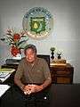
Incumbent Mayor Leonardo de Leon
-

Angat Municipal Hall (Located beside Sta. Monica Church)
-

SC Associate Justice Martin Villarama’s ancestral house and lot (Barangay Marungko)
-
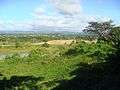
Overlooking view of Angat quarry and Sierra Madre (Philippines)
-

Angat River from overlooking view

References
- ↑ "Official City/Municipal 2013 Election Results". Intramuros, Manila, Philippines: Commission on Elections (COMELEC). 11 September 2013. Retrieved 10 October 2013.
- ↑ "Province: BULACAN". PSGC Interactive. Makati City, Philippines: National Statistical Coordination Board. Retrieved 10 October 2013.
- 1 2 3 4 5 6 "Region III (CENTRAL LUZON)". Census of Population (2015): Total Population by Province, City, Municipality and Barangay (Report). PSA. Retrieved 20 June 2016.
- ↑ "Region III (CENTRAL LUZON)". Census of Population and Housing (2010): Total Population by Province, City, Municipality and Barangay (Report). NSO. Retrieved 29 June 2016.
- ↑ Reference 6
- ↑ "Schools & Utility Services". Municipality of Angat.
External links
| Wikimedia Commons has media related to Angat, Bulacan. |
- Philippine Standard Geographic Code
- Philippine Census Information
- Angat Bulacan
- Angat, Bulacan at WN
- Angat.NET Our town, Our Home
 |
San Rafael | Doña Remedios Trinidad | | |
| Bustos | |
Norzagaray | ||
| ||||
| | ||||
| Pandi | Santa Maria |
Malolos (capital) | |
| Municipalities | |
| Component cities | |
| Misc. | |