Andranotsimisiamalona River
| Andranotsimisiamalona River | |
| River | |
 Ambohitra Massif river system | |
| Country | |
|---|---|
| Region | Diana |
| Source | |
| - location | Ambohitra Massif, Diana |
| - elevation | 1,354 m (4,442 ft) |
| Mouth | Saharenana River |
| - location | Diana |
| - elevation | 100 m (328 ft) |
| - coordinates | MG 12°28′00″S 49°21′20″E / 12.46667°S 49.35556°ECoordinates: MG 12°28′00″S 49°21′20″E / 12.46667°S 49.35556°E |
| Length | 51.2 km (32 mi) |
| Basin | 59.9 km2 (23 sq mi) |
| Discharge | for near Antananandrenitelo |
| - average | 0.38 m3/s (13 cu ft/s) [1] |
| - max | 2.42 m3/s (85 cu ft/s) |
| - min | 0.128 m3/s (5 cu ft/s) |
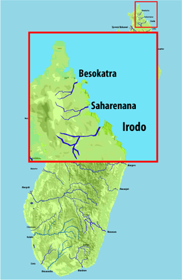
The Andranotsimisiamalona River is located in northern Madagascar. Its sources are situated in the Ambohitra Massif; it flows into the Saharenana River above Antananandrenitelo.[1]
References
- 1 2 Bauduin, D.; Servat, E. "Etude d'Hydrologie à Usage Agricole" (PDF). Institut Français de Recherche Scientifique pour le Développement en Coopération. pp. 14–16. Retrieved 23 April 2016. (French)
This article is issued from Wikipedia - version of the 4/23/2016. The text is available under the Creative Commons Attribution/Share Alike but additional terms may apply for the media files.