An der Poststraße
| An der Poststraße | |
|---|---|
 An der Poststraße | |
Location of An der Poststraße within Burgenlandkreis district 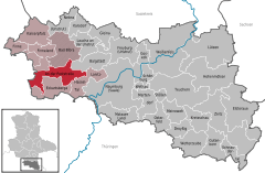
 | |
| Coordinates: 51°10′N 11°33′E / 51.167°N 11.550°ECoordinates: 51°10′N 11°33′E / 51.167°N 11.550°E | |
| Country | Germany |
| State | Saxony-Anhalt |
| District | Burgenlandkreis |
| Municipal assoc. | An der Finne |
| Government | |
| • Mayor | Ingrid Hesse |
| Area | |
| • Total | 44.45 km2 (17.16 sq mi) |
| Population (2015-12-31)[1] | |
| • Total | 1,698 |
| • Density | 38/km2 (99/sq mi) |
| Time zone | CET/CEST (UTC+1/+2) |
| Postal codes | 06647 |
| Dialling codes | 034463, 034465, 034467 |
| Vehicle registration | BLK |
An der Poststraße is a municipality in the Burgenlandkreis district, in Saxony-Anhalt, Germany. It was formed by the merger of the previously independent municipalities Klosterhäseler, Wischroda and Herrengosserstedt, on 1 July 2009.
Etymology

"Alte Poststraße", the old post road between the B 250 und Klosterhäseler
The name An der Poststraße translates as at the post road and is derived from the "old post road" between Leipzig and Kassel. This route was of importance until the "Frankfurt-Leipziger-Chaussee" was rolled out through Eckartsberga, Gernstedt and Kösen in the year 1806.
Subdistricts
The following subdistricts belong to the An der Poststraße municipality:
| Subdistrict | Population |
|---|---|
| Braunsroda (An der Poststraße) | 209 |
| Burgheßler | 188 |
| Klosterhäseler | 328 |
| Frankroda | 72 |
| Gößnitz (An der Poststraße) | 156 |
| Herrengosserstedt | 623 |
| Pleismar | 86 |
| Schimmel (An der Poststraße) | 50 |
| Wischroda | 156 |
References
- ↑ "Bevölkerung der Gemeinden – Stand: 31.12.2015" (PDF). Statistisches Landesamt Sachsen-Anhalt (in German).

This article is issued from Wikipedia - version of the 8/3/2016. The text is available under the Creative Commons Attribution/Share Alike but additional terms may apply for the media files.