Ampriani
| Ampriani | |
|---|---|
|
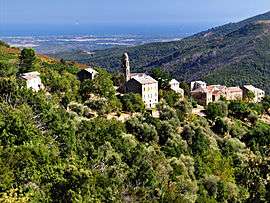
Ampriani and the Tallone plain | |
 Ampriani | |
|
Location within Corsica region 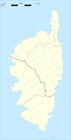 Ampriani | |
| Coordinates: 42°15′06″N 9°21′26″E / 42.2517°N 9.3572°ECoordinates: 42°15′06″N 9°21′26″E / 42.2517°N 9.3572°E | |
| Country | France |
| Region | Corsica |
| Department | Haute-Corse |
| Arrondissement | Corte |
| Canton | Moïta-Verde |
| Intercommunality | Oriente |
| Government | |
| • Mayor (2001–2020) | Pierre François Dompietrini |
| Area1 | 2 km2 (0.8 sq mi) |
| Population (2009)2 | 13 |
| • Density | 6.5/km2 (17/sq mi) |
| Time zone | CET (UTC+1) |
| • Summer (DST) | CEST (UTC+2) |
| INSEE/Postal code | 2B015 / 20272 |
| Elevation |
320–749 m (1,050–2,457 ft) (avg. 560 m or 1,840 ft) |
|
1 French Land Register data, which excludes lakes, ponds, glaciers > 1 km² (0.386 sq mi or 247 acres) and river estuaries. 2 Population without double counting: residents of multiple communes (e.g., students and military personnel) only counted once. | |
Ampriani is a French commune in the Haute-Corse department on the island of Corsica.
Geography
Ampriani is a commune on the eastern side of Corsica in the heart of the Pieve (religious jurisdiction) in the Serra in the canton of Moita Verde. It is 30 km by road north-west from Aleria and significantly less in a direct line and 16 km south-west of Moïta in the Valley of the Cursigliese. Access is by the D116 road from Tallone in the south-east which continues north of the village north-west to Zuani. Ampriani is a small village of a single row of houses with a watchtower aligned on a ridge at an altitude of about 600 metres (lowest point 320 m, highest point: 749 m) overlooking the valley and almost the entire plain. The village is nearly deserted in winter, but has about a hundred people in summer. The road leading to the village is a dead end and ends on the old "helicopter pad". The terrain in the commune is rugged and heavily forested.[1]
Neighbouring communes and villages[1]
 |
Zuani | Zalana | | |
| |
||||
| ||||
| | ||||
| Piedicorte-di-Gaggio | Pancheraccia | Tallone |
History
Middle Ages
In the 16th century Ampriani was part of the Pieve di a Serra with two other villages which are in the current commune of Zuani. Around 1520 the three villages making up the Pieve were called:
- Alpriano for Ampriani;
- Cuiani for Zuani;
- La Valle di Sagano.
From the 18th century to today
Before the 18th century Ampriani was still part of the Pieve di a Serra but to the three villages in 1520 were added the villages of:
The three original villages, meanwhile, had become:
- Ampriani;
- Zuvani (Zuani);
- La Valle di Sagano had disappeared.
In 1790, with the French Revolution the Pieves became cantons. The Pieve di a Serra became the Canton of Serra, before taking the name Canton of Moïta in 1830.
In 1954 the communes of Aléria, Ampriani, Matra, Moïta, Pianello, Tallone, Zalana, and Zuani formed the Canton of Moïta.
Between 1971 and 1973, the two cantons of Moïta and Pietra di Verde were merged. They form the current Canton of Moita Verde.
Today the Canton of Moita Verde is composed of fourteen communes. These are the six communes in the Canton of Pietra: Canale-di-Verde, Linguizzetta, Tox, Campi, A Petra, and Chiatra (to which can be added the two hamlets of Monticchio and Ersagie, which now belong respectively to the communes of Pietra-di-Verde and Chiatra and the second to U Monte). To these are added the eight communes of the Canton of Moïta to create the Canton of Moïta-Verde.[2]
Administration
List of Successive Mayors[3]
| From | To | Name | Party | Position |
|---|---|---|---|---|
| 1965 | 1995 | Ange Michel Renucci | ||
| 1995 | 2008 | Huguette Ghilardi | ||
| 2001 | 2020 | Pierre François Dompietrini |
(Not all data is known)
Demography
In 2009 the commune had 13 inhabitants. The evolution of the number of inhabitants is known through the population censuses conducted in the commune since 1793. From the 21st century, a census of communes with fewer than 10,000 inhabitants is held every five years, unlike larger towns that have a sample survey every year.[Note 1]
| 1793 | 1800 | 1806 | 1821 | 1831 | 1836 | 1841 | 1846 | 1851 |
|---|---|---|---|---|---|---|---|---|
| - | 88 | 124 | 142 | 160 | 162 | 158 | 168 | 171 |
| 1856 | 1861 | 1866 | 1872 | 1876 | 1881 | 1886 | 1891 | 1896 |
|---|---|---|---|---|---|---|---|---|
| 164 | 137 | 142 | 116 | 117 | 94 | 110 | 112 | 111 |
| 1901 | 1906 | 1911 | 1921 | 1926 | 1931 | 1936 | 1946 | 1954 |
|---|---|---|---|---|---|---|---|---|
| 111 | 135 | 135 | 95 | 88 | 94 | 127 | 74 | 39 |
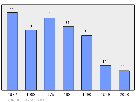
| 1962 | 1968 | 1975 | 1982 | 1990 | 1999 | 2006 | 2009 | - |
|---|---|---|---|---|---|---|---|---|
| 44 | 34 | 41 | 36 | 31 | 14 | 9 | 13 | - |
Sources : Ldh/EHESS/Cassini until 1962, INSEE database from 1968 (population without double counting and municipal population from 2006)
Sites and Monuments

- The Convent of Saint Francis of Zuani (1730)
 is registered as an historical monument.[4]
See also
External links
- Ampriani on Lion1906
- Ampriani on Google Maps
- Ampriani on Géoportail, National Geographic Institute (IGN) website (French)
- Ampriani on the INSEE website (French)
- INSEE (French)
Notes and references
Notes
- ↑ At the beginning of the 21st century, the methods of identification have been modified by law No. 2002-276 of 27 February 2002 , the so-called "law of local democracy" and in particular Title V "census operations" which allow, after a transitional period running from 2004 to 2008, the annual publication of the legal population of the different French administrative districts. For communes with a population greater than 10,000 inhabitants, a sample survey is conducted annually, the entire territory of these communes is taken into account at the end of the period of five years. The first "legal population" after 1999 under this new law came into force on 1 January 2009 and was based on the census of 2006.
References
- 1 2 Google Maps
- ↑ "France, le trésor des régions: Département: Haut-Corse" (in French). Retrieved 2008-05-06..
- ↑ List of Mayors of France
- ↑ Ministry of Culture, Mérimée PA2B000011 Convent of Saint Francis of Zuani (French)
| Wikimedia Commons has media related to Ampriani. |