Tha Chana District
| Tha Chana ท่าชนะ | |
|---|---|
| Amphoe | |
 Amphoe location in Surat Thani Province | |
| Coordinates: 9°34′20″N 99°9′54″E / 9.57222°N 99.16500°ECoordinates: 9°34′20″N 99°9′54″E / 9.57222°N 99.16500°E | |
| Country |
|
| Province | Surat Thani |
| Seat | Tha Chana |
| Area | |
| • Total | 687.4 km2 (265.4 sq mi) |
| Population (2015) | |
| • Total | 54,415 |
| • Density | 72.6/km2 (188/sq mi) |
| Time zone | ICT (UTC+7) |
| Postal code | 84170 |
| Geocode | 8407 |
Tha Chana (Thai: ท่าชนะ) is a district (amphoe) in the north of Surat Thani Province of southern Thailand.
History
The district is quite old. Originally named Prasong (ประสงค์), it was a subordinate of mueang Lang Suan. In 1906 it was reassigned to mueang Chaiya,[1] which is now Surat Thani Province. The seat of the district was in current-day Ban Tha Krachai. In 1909 as part of thesaphiban administrative reform most of the tambon were transferred to be administrated directly by Phum Riang district, nowadays Chaiya district. The remaining of the district was reduced to a minor district (king amphoe), which then also became a subordinate of Phum Riang district.[2] On 29 June 1919 it was abolished completely.[3]
As the area developed in the following decades, the district was recreated on 1 January 1948 as a minor district.[4] The seat of the minor district was in Ban Talad Nong Wai in tambon Tha Chana, thus the district was also named Tha Chana. On 5 June 1956 it was elevated to full amphoe status.[5]
Etymology
The name Tha Chana means "harbour of victory" and dates back to the expedition of vice-king Boworn Maha Surasinghanat to the south to fight back the Burmese invasion. During his victorious return in 1785 he founded the temple Wat Khotharam (now named Wat Amphawan), and also created two stele announcing his victory. One was placed in tambon Wang, the other in tambon Tha Chana.
Geography
Neighboring districts are Chaiya to the south, Phato to the northeast and Lamae to the north. The last two districts belong to Chumphon Province. To the east is the Gulf of Thailand.
Administration
Central administration
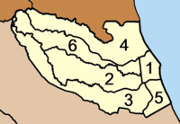
The district Tha Chana is subdivided into 6 subdistricts (Tambon), which are further subdivided into 82 administrative villages (Muban).
|
 |
Local administration
There is one subdistrict municipality (Thesaban Tambon) in the district:
- Tha Chana (Thai: เทศบาลตำบลท่าชนะ) consisting of parts of the subdistricts Tha Chana, Samo Thong.
There are 6 subdistrict administrative organizations (SAO) in the district:
- Tha Chana (Thai: องค์การบริหารส่วนตำบลท่าชนะ) consisting of parts of the subdistrict Tha Chana.
- Samo Thong (Thai: องค์การบริหารส่วนตำบลสมอทอง) consisting of parts of the subdistrict Samo Thong.
- Prasong (Thai: องค์การบริหารส่วนตำบลประสงค์) consisting of the complete subdistrict Prasong.
- Khan Thuli (Thai: องค์การบริหารส่วนตำบลคันธุลี) consisting of the complete subdistrict Khan Thuli.
- Wang (Thai: องค์การบริหารส่วนตำบลวัง) consisting of the complete subdistrict Wang.
- Khlong Pha (Thai: องค์การบริหารส่วนตำบลคลองพา) consisting of the complete subdistrict Khlong Pha.
References
- ↑ แจ้งความกระทรวงมหาดไทย: เรื่อง โอนอำเภอประสงค์จากเขตเมืองหลังสวนมาเป็นเขตเมืองไชยา รวมอยู่ในบ้านพุมเรียงและศาลพุมเรียง (PDF). Royal Gazette (in Thai). 23 (25): 626. 16 Sep 1906.
- ↑ แจ้งความกระทรวงมหาดไทย เรื่อง ยุบอำเภอประสงค์แขวงเมืองไชยา ลงเป็นกิ่งอำเภอ (PDF). Royal Gazette (in Thai). 26 (0 ง): 137. 2 May 1909.
- ↑ ประกาศ เรื่อง ยุบกิ่งอำเภอประสงค์รวมกับอำเภอเมืองไชยา (PDF). Royal Gazette (in Thai). 36 (0 ก): 120. 29 Jun 1919.
- ↑ ประกาศกระทรวงมหาดไทย เรื่อง ยกฐานะตำบลขึ้นเป็นกิ่งอำเภอ (PDF). Royal Gazette (in Thai). 64 (60 ง): 3288–3293. 9 Dec 1947.
- ↑ พระราชกฤษฎีกาจัดตั้งอำเภอนาทวี อำเภอสะบ้าย้อย อำเภอคำชะอี อำเภอย่านตาขาว อำเภอวัดโบสถ์ อำเภอหนองบัว อำเภอวัฒนานคร อำเภอแสวงหา อำเภอท่าชนะ อำเภอพระพุทธบาท อำเภอโนนสัง อำเภอบำเหน็จณรงค์ อำเภอคอนสวรรค์ อำเภอบ้านโฮ่ง อำเภอคีรีมาศ อำเภอชนแดน อำเภอแม่แจ่ม อำเภอไทรน้อย และอำเภอบ้านแพง พ.ศ. ๒๔๙๙ (PDF). Royal Gazette (in Thai). 73 (46 ก): 657–661. 5 Jun 1956.
- ↑ "Population statistics 2015" (in Thai). Department of Provincial Administration. Retrieved 2016-03-22.
External links
- amphoe.com (Thai)
- http://www.thachanacity.org (Thai)