Si Satchanalai District
| Si Satchanalai ศรีสัชนาลัย | |
|---|---|
| Amphoe | |
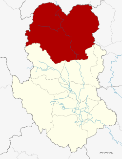 Amphoe location in Sukhothai Province | |
| Coordinates: 17°31′2″N 99°45′37″E / 17.51722°N 99.76028°ECoordinates: 17°31′2″N 99°45′37″E / 17.51722°N 99.76028°E | |
| Country |
|
| Province | Sukhothai |
| Seat | Hat Siao |
| Area | |
| • Total | 2,050.511 km2 (791.707 sq mi) |
| Population (2005) | |
| • Total | 95,198 |
| • Density | 46.4/km2 (120/sq mi) |
| Time zone | THA (UTC+7) |
| Postal code | 64130 |
| Geocode | 6405 |
Si Satchanalai (Thai: ศรีสัชนาลัย) is the northernmost district (Amphoe) of Sukhothai Province, in the lower northern region of Thailand.[1][2] Si may also be transliterated as Sri.
Geography
Neighboring districts are (from the southwest clockwise): Si Nakhon, Sawankhalok, Thung Saliam of Sukhothai Province, Thoen of Lampang Province, Wang Chin of Phrae Province, Laplae and Tron of Uttaradit Province.
The Phi Pan Nam Mountains dominate the landscape of the district.
History
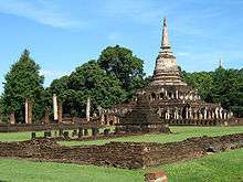
Si Satchanalai was the second-most important town of the Sukhothai kingdom. The ruins of its temples are now part of the Si Satchanalai historical park, which is part of UNESCO world heritage site of Sukhothai.
The district was renamed from Hat Siao to Si Satchanalai in 1939.[3]
Administration
The district is subdivided into 11 subdistricts (tambon), which are further subdivided into 148 villages (muban). There are two townships (thesaban tambon) - Hat Siao covers parts of tambon hat Siao, and Si Satchanalai cover the whole tambon Si Satchanalai, Tha Chai and parts of Nong O. There are further 8 Tambon administrative organizations (TAO).
| No. | Name | Thai name | Villages | Inh. | |
|---|---|---|---|---|---|
| 1. | Hat Siao | หาดเสี้ยว | 6 | 7,299 | |
| 2. | Pa Ngio | ป่างิ้ว | 12 | 7,267 | |
| 3. | Mae Sam | แม่สำ | 22 | 7,698 | |
| 4. | Mae Sin | แม่สิน | 25 | 12,774 | |
| 5. | Ban Tuek | บ้านตึก | 14 | 10,460 | |
| 6. | Nong O | หนองอ้อ | 11 | 6,859 | |
| 7. | Tha Chai | ท่าชัย | 10 | 10,892 | |
| 8. | Si Satchanalai | ศรีสัชนาลัย | 12 | 5,800 | |
| 9. | Dong Khu | ดงคู่ | 9 | 5,926 | |
| 10. | Ban Kaeng | บ้านแก่ง | 13 | 9,939 | |
| 11. | San Chit | สารจิตร | 14 | 10,284 |
References
- ↑ http://www.sukhothai.go.th/3584/data/data_01.htm
- ↑ http://tourisminvest.tat.or.th/en/component/content/article?id=62
- ↑ พระราชกฤษฎีกาเปลี่ยนนามอำเภอ กิ่งอำเภอ และตำบลบางแห่ง พุทธศักราช ๒๔๘๒ (PDF). Royal Gazette (in Thai). 56 (0 ก): 354–364. April 17, 1939.
External links
- amphoe.com (Thai)
- Si Satchanalai Informations and History (Thai:Translation ready)