Na Chueak District
| Na Chueak นาเชือก | |
|---|---|
| Amphoe | |
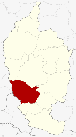 Amphoe location in Maha Sarakham Province | |
| Coordinates: 15°48′0″N 103°1′54″E / 15.80000°N 103.03167°ECoordinates: 15°48′0″N 103°1′54″E / 15.80000°N 103.03167°E | |
| Country | Thailand |
| Province | Maha Sarakham |
| Area | |
| • Total | 528.198 km2 (203.938 sq mi) |
| Population (2008) | |
| • Total | 60,856 |
| • Density | 115.2/km2 (298/sq mi) |
| Time zone | ICT (UTC+7) |
| Postal code | 44170 |
| Geocode | 4407 |
Na Chueak (Thai: นาเชือก) is a district (amphoe) in the south of Maha Sarakham Province, northeastern Thailand.
Geography
Neighboring districts are (from the north clockwise) Kut Rang, Borabue, Wapi Pathum, Na Dun, and Yang Sisurat of Maha Sarakham Province, Na Pho of Buriram Province, and Nong Song Hong and Pueai Noi of Khon Kaen Province.
History
The area was made a minor district (king amphoe) on 19 July 1960 by splitting it off from Borabue District.[1] It was upgraded to a full district in 1963.[2]
Administration
The district is divided into 10 sub-districts (tambon), which are further subdivided into 146 villages (muban). Na Chueak is a sub-district municipality (thesaban tambon) which covers parts of the tambon Na Chueak and Khwao Rai. There are a further 10 tambon administrative organizations (TAO).
| No. | Name | Thai | Villages | Pop. |
|---|---|---|---|---|
| 1. | Na Chueak | นาเชือก | 18 | 8,825 |
| 2. | Samrong | สำโรง | 15 | 6,839 |
| 3. | Nong Daeng | หนองแดง | 10 | 3,969 |
| 4. | Khwao Rai | เขวาไร่ | 19 | 7,735 |
| 5. | Nong Pho | หนองโพธิ์ | 12 | 5,237 |
| 6. | Po Phan | ปอพาน | 16 | 8,055 |
| 7. | Nong Mek | หนองเม็ก | 20 | 6,661 |
| 8. | Nong Ruea | หนองเรือ | 13 | 5,166 |
| 9. | Nong Kung | หนองกุง | 11 | 3,949 |
| 10. | San Pa Tong | สันป่าตอง | 12 | 4,420 |
References
- ↑ ประกาศกระทรวงมหาดไทย เรื่อง ยกฐานะตำบลขึ้นเป็นกิ่งอำเภอ (PDF). Royal Gazette (in Thai). 77 (67 ง): 1885–1886. 1960-08-16.
- ↑ พระราชกฤษฎีกาตั้งอำเภอบ่อพลอย อำเภอไทรโยค อำเภอหนองเรือ อำเภอหนองสองห้อง อำเภอประทาย อำเภอห้วยแถลง อำเภอละหานทราย อำเภอกุยบุรี อำเภอตาพระยา อำเภอหนองไผ่ อำเภอนาเชือก อำเภอวัดเพลง อำเภอพนัสนิคม อำเภอภูกระดึง อำเภอปรางค์กู่ อำเภอท่าช้าง อำเภอบ้านด่านลานหอย อำเภอบ้านดง อำเภอสว่างอารมณ์ และอำเภอกุดชุม พ.ศ. ๒๕๐๖ (PDF). Royal Gazette (in Thai). 80 (72 ก): 362. 1963-07-16.
External links
- amphoe.com (Thai)