Mueang Chanthaburi District
| Mueang Chanthaburi เมืองจันทบุรี | |
|---|---|
| Amphoe | |
|
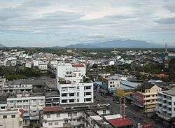
Chanthaburi Town | |
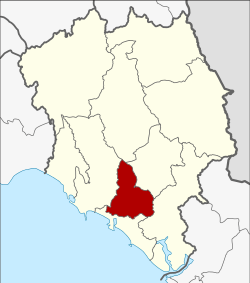 Amphoe location in Chanthaburi Province | |
| Coordinates: 12°36′38″N 102°6′15″E / 12.61056°N 102.10417°ECoordinates: 12°36′38″N 102°6′15″E / 12.61056°N 102.10417°E | |
| Country |
|
| Province | Chanthaburi |
| Seat | Wat Mai |
| Tambon | 11 |
| Muban | 98 |
| Area | |
| • Total | 253.093 km2 (97.720 sq mi) |
| Population (2013) | |
| • Total | 125,924 |
| • Density | 471.0/km2 (1,220/sq mi) |
| Time zone | ICT (UTC+7) |
| Postal code | 22000 |
| Geocode | 2201 |
Mueang Chanthaburi (Thai: เมืองจันทบุรี, pronounced [mɯ̄aŋ t͡ɕān.tʰáʔ.bū.rīː]) is the capital district (amphoe mueang) of Chanthaburi Province, eastern Thailand.
Geography
Neighboring districts are (from the north clockwise) Khao Khitchakut, Makham, Khlung, Laem Sing and Tha Mai of Chanthaburi Province.
Administration
Central administration
The district Mueang Chanthaburi is subdivided into 11 subdistricts (tambon), which are further subdivided into 98 administrative villages (muban).
| No. | Name | Thai | Villages | Pop.[1] |
|---|---|---|---|---|
| 1. | Talat | ตลาด | - | 9,288 |
| 2. | Wat Mai | วัดใหม่ | - | 15,009 |
| 3. | Khlong Narai | คลองนารายณ์ | 14 | 8,053 |
| 4. | Ko Khwang | เกาะขวาง | 9 | 14,352 |
| 5. | Khom Bang | คมบาง | 10 | 4,305 |
| 6. | Tha Chang | ท่าช้าง | 12 | 28,286 |
| 7. | Chanthanimit | จันทนิมิต | 9 | 13,017 |
| 8. | Bang Kacha | บางกะจะ | 10 | 10,529 |
| 9. | Salaeng | แสลง | 10 | 4,987 |
| 10. | Nong Bua | หนองบัว | 11 | 6,040 |
| 11. | Phlapphla | พลับพลา | 13 | 12,058 |
Local administration
There are 3 towns (thesaban mueang) in the district:
- Chanthaburi (Thai: เทศบาลเมืองจันทบุรี) consisting of the complete subdistrict Talat and Wat Mai.
- Chanthanimit (Thai: เทศบาลเมืองจันทนิมิต) consisting of the complete subdistrict Chanthanimit.
- Tha Chang (Thai: เทศบาลเมืองท่าช้าง) consisting of parts of the subdistrict Tha Chang.
There are 7 subdistrict municipalities (thesaban tambon) in the district:
- Khai Noen Wong (Thai: เทศบาลตำบลค่ายเนินวง) consisting of parts of the subdistrict Bang Kacha.
- Salaeng (Thai: เทศบาลตำบลแสลง) consisting of the complete subdistrict Salaeng.
- Phlapphla (Thai: เทศบาลตำบลพลับพลา) consisting of parts of the subdistrict Phlapphla.
- Bang Kacha (Thai: เทศบาลตำบลบางกะจะ) consisting of parts of the subdistrict Bang Kacha.
- Phlapphla Narai (Thai: เทศบาลตำบลพลับพลานารายณ์) consisting of parts of the subdistricts Khlong Narai and Phlapphla.
- Nong Bua (Thai: เทศบาลตำบลหนองบัว) consisting of parts of the subdistrict Nong Bua.
- Ko Khwang (Thai: เทศบาลตำบลเกาะขวาง) consisting of the complete subdistrict Ko Khwang.
There are 4 subdistrict administrative organizations (SAO) in the district:
- Khlong Narai (Thai: องค์การบริหารส่วนตำบลคลองนารายณ์) consisting of parts of the subdistrict Khlong Narai.
- Khom Bang (Thai: องค์การบริหารส่วนตำบลคมบาง) consisting of the complete subdistrict Khom Bang.
- Tha Chang (Thai: องค์การบริหารส่วนตำบลท่าช้าง) consisting of parts of the subdistrict Tha Chang.
- Nong Bua (Thai: องค์การบริหารส่วนตำบลหนองบัว) consisting of parts of the subdistrict Nong Bua.
References
- ↑ "Population statistics 2013" (in Thai). Department of Provincial Administration. Retrieved 2014-11-09.
External links
This article is issued from Wikipedia - version of the 3/3/2016. The text is available under the Creative Commons Attribution/Share Alike but additional terms may apply for the media files.