Amfreville, Calvados
| Amfreville | ||
|---|---|---|
|
The Square and Saint Martin church | ||
| ||
 Amfreville | ||
|
Location within Normandy region  Amfreville | ||
| Coordinates: 49°14′54″N 0°14′06″W / 49.2483°N 0.235°WCoordinates: 49°14′54″N 0°14′06″W / 49.2483°N 0.235°W | ||
| Country | France | |
| Region | Normandy | |
| Department | Calvados | |
| Arrondissement | Caen | |
| Canton | Cabourg | |
| Intercommunality | Cabalor | |
| Government | ||
| • Mayor (2008–2020) | Xavier Madelaine | |
| Area1 | 6.06 km2 (2.34 sq mi) | |
| Population (2009)2 | 1,188 | |
| • Density | 200/km2 (510/sq mi) | |
| Time zone | CET (UTC+1) | |
| • Summer (DST) | CEST (UTC+2) | |
| INSEE/Postal code | 14009 / 14860 | |
| Elevation |
0–57 m (0–187 ft) (avg. 50 m or 160 ft) | |
|
1 French Land Register data, which excludes lakes, ponds, glaciers > 1 km² (0.386 sq mi or 247 acres) and river estuaries. 2 Population without double counting: residents of multiple communes (e.g., students and military personnel) only counted once. | ||

Amfreville is a French commune in the Calvados department in the Normandy region of north-western France.
The inhabitants of the commune are known as Amfrevillais or Amfrevillaises[1]
Geography
Amfreville is located some 25 km north-west of Caen and 1 km south-east of Ouistreham mostly on the right bank of the Orne with a small portion on the left bank. It can be accessed by the D514 from Sallenelles in the north passing through the west of the commune then continuing south then west to Bénouville. Access to the village is by the D37B from Breville-les-Monts in the south-east and continuing through the village north to Sallenelles. There is also the D236 going east from the village to Bavent. There are several hamlets apart from the village: Hameau Oger and Hameau La Rue form a continuous urban area with the main village and the hamlets of La Basse Ecarde and La Haute Ecarde are to the west. The rest of the commune and the entire left bank of the Orne portion are farmland.[2]
The Orne river separates the two parts of the commune with no direct access across the river - the nearest crossing is on the D514 to the south of the commune. A stream forms the northern border of the commune flowing into the Orne.[2]
Neighbouring communes and villages[2]
 |
Ouistreham | Sallenelles | Gonneville-en-Auge | |
| Saint-Aubin-d'Arquenay | |
Petiville | ||
| ||||
| | ||||
| Bénouville | Ranville | Breville-les-Monts |
History
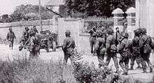
Amfreville is located close to Omaha Beach on the Normandy coast, which is one of the beaches where the Allies executed their Normandy landings. It is also close to the important medieval naval city of Cherbourg, which figured in the Allied landings. Amfreville is considered to have been officially "liberated" from the German occupation of World War II on 6 June 1944.
Amfreville is understood to be the ancestral home of the Umfraville family of Anglo-Norman nobles who occupied England under William the Conqueror and his successors, and went on to become British nobility under the titles the Barons of Prudhoe and the Lords of Redesdale, and later also gained Scottish lands and the title Earl of Angus.
Images of these historical associations with the Norman Conquest of 1066 and the Normandy Landings of 1944 are incorporated in the town's heraldry.
Heraldry
 |
Blazon: Party per pale, first Azure a soldier of Or suspended from a parachute argent all surmounted by a dove the same, in chief gules charged with two lions passant guardant one over the other; second of Vert with a garb of Or, in chief Azure with two fesse wavy in argent debruised by a barque contourned of Gules sailed the same. |
Administration

List of Successive Mayors[3]
| From | To | Name | Party | Position |
|---|---|---|---|---|
| 1989 | 2020 | Xavier Madelaine | PS | SNCF Officer |
(Not all data is known)
Twinning
Amfreville has twinning associations with:[4]
Demography
In 2009 the commune had 1,188 inhabitants. The evolution of the number of inhabitants is known through the population censuses conducted in the commune since 1793. From the 21st century, a census of communes with fewer than 10,000 inhabitants is held every five years, unlike larger towns that have a sample survey every year.[Note 1]
| 1793 | 1800 | 1806 | 1821 | 1831 | 1836 | 1841 | 1846 | 1851 |
|---|---|---|---|---|---|---|---|---|
| 700 | 610 | 619 | 573 | 564 | - | 623 | 608 | 586 |
| 1856 | 1861 | 1866 | 1872 | 1876 | 1881 | 1886 | 1891 | 1896 |
|---|---|---|---|---|---|---|---|---|
| 548 | 575 | 533 | 482 | 460 | 412 | 410 | 387 | 387 |
| 1901 | 1906 | 1911 | 1921 | 1926 | 1931 | 1936 | 1946 | 1954 |
|---|---|---|---|---|---|---|---|---|
| 316 | 333 | 318 | 335 | 350 | 378 | 357 | 386 | 404 |
| 1962 | 1968 | 1975 | 1982 | 1990 | 1999 | 2006 | 2009 | - |
|---|---|---|---|---|---|---|---|---|
| 482 | 444 | 615 | 819 | 905 | 1,056 | 1,172 | 1,188 | - |
Sources : Ldh/EHESS/Cassini until 1962, INSEE database from 1968 (population without double counting and municipal population from 2006)

Sites and monuments

- Le Plain is a place with a tree plantation, a church, and horses. It is registered as a site of ecological interest for flora and fauna.
See also
Bibliogrtaphy
- Amfréville en Baie de l’Orne, Gillonne and Rémi Desquesnes, 2001 (French)
External links
- Amfreville on Lion1906
- Amfreville on Google Maps
- Amfreville on Géoportail, National Geographic Institute (IGN) website (French)
- Amfreville on the 1750 Cassini Map
- Amfreville on the INSEE website (French)
- INSEE (French)
Notes and references
Notes
- ↑ At the beginning of the 21st century, the methods of identification have been modified by law No. 2002-276 of 27 February 2002 , the so-called "law of local democracy" and in particular Title V "census operations" which allow, after a transitional period running from 2004 to 2008, the annual publication of the legal population of the different French administrative districts. For communes with a population greater than 10,000 inhabitants, a sample survey is conducted annually, the entire territory of these communes is taken into account at the end of the period of five years. The first "legal population" after 1999 under this new law came into force on 1 January 2009 and was based on the census of 2006.
References
| Wikimedia Commons has media related to Amfreville, Calvados. |