Amecameca
| La casa de los Meca | ||
|---|---|---|
| Town & Municipality | ||
|
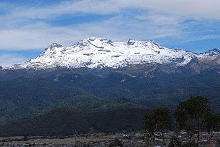
Amecameca with the Sierra Nevada in background | ||
| ||
|
La casa de los Meca | ||
| Coordinates: 19°07′40″N 98°45′46″W / 19.12778°N 98.76278°W | ||
| Country |
| |
| State | State of Mexico | |
| Municipal Status | 1824 | |
| Government | ||
| • Municipal President | Carlos Santos Amador | |
| Elevation (of seat) | 2,480 m (8,140 ft) | |
| Population (2010) Municipality | ||
| • Municipality | 48,421 | |
| • Seat | 31,422 | |
| Time zone | CST (UTC-6) | |
| Postal code (of seat) | 56900 | |
| Demonym | Amequense | |
| Website | http://www.amecameca.gob.mx | |


Amecameca (formally Amecameca de Juárez) is a town and municipality located in the eastern panhandle of Mexico State between Mexico City and the Iztaccíhuatl and Popocatépetl volcanos of the Sierra Nevada mountain range.[1][2] It is located on federal highway 115 which leads to Cuautla, which is called the Volcano Route (Ruta de los Volcanes).[1] This area is popular with weekend visitors from Mexico City, Puebla and Morelos to enjoy the scenery of the mountains, eat local foods, visit the Sanctuary of the Señor del Sacromonte, the Panoaya Hacienda and other attractions. However, when Popocatépetl is active, tourism here drops dramatically.[3] The area receives a large number of visitors during the annual Carnival/Festival del Señor del Sacromonte, which extends over the week containing Ash Wednesday and is considered to be one of the most important festivals in Mexico State.[4]
The name Amecameca comes from Nahuatl. It has been interpreted to mean “place where the papers signal or mark,”[2][5] or “paper used ceremoniously.”[6][7] The paper is called amatl, which is a bark paper used to dress images of gods and is still made as a craft.[7] “de Juárez” was added to the name in 1887 by the government of the state of Mexico in honor of Benito Juárez.[8]
History
Settled human habitation in this area began early mostly in dispersed small villages. The Chichimeca tribe called the Totolimpanecas arrived around 1268 and populated the areas now known as Itztlacozauhcan, Tlayllotlacan Amaquemecan. Later arrivals occupied areas known as Tzacualtitlan Tenanco Amaquemecan and Atlauhtlan Tzacualtitlan Amaquemecan. These groups had their own small dominions. In 1336, another dominion called Tlaylloltlacan Teohuacan was formed. All these communities were collectively known as the Amaquemecans. Religious practices in this area were mostly performed in urban temples and shrines located on mountaintops and caves. In 1465, the Aztecs conquered this area, along with the rest of the Valley of Chalco, replacing local leaders with military governors and transforming the area into a tributary province with neighboring Tlalmanalco as capital.[2]
Hernán Cortés arrived here in 1519 and noted that the houses here were well built with about 20,000 inhabitants. In 1521, the leaders here were Quetzalmazatzin and his brother Tecuanxayacatzin due to the help they gave Cortés in conquering Tenochtitlan. Soon thereafter, they were poisoned. After the Spanish conquest of the Aztec Empire, Franciscans were in charge of evangelizing the area. In 1525, Martín de Valencia set fire to the local priests’ houses on the Amaqueme Mountain (Sacromonte), and in 1527 construction of the Franciscan monastery began. The cult to the Santo Entierro (Holy Burial) or Señor del Sacromonte was begun to replace an earlier pagan cult at this site. The La Asuncion Church was begun in 1547, along with a number of other places of worship. Construction was finished in 1564. The tower was not built until the mid-17th century. From the 1540s to the end of the century, there was much civil strife among the native population. Some indigenous rule was restored but it would end for good by the 17th century.[2] The raising of European foodstuffs such as wheat and sheep began early with commercial agriculture becoming the basis of the economy by 1550. The area also became an important pass linking Mexico City with points east with many travelers and merchants passing through. By 1599, Amecameca has become the head of a district with thirteen dependencies with an area of about 128km2.[2]
A major earthquake occurred here in 1704 which destroyed many houses as well as the roof of the La Asuncion Church. It was repaired from 1712 to 1719.[2]
The area remained a farming area, mostly with family plots through the rest of the colonial period. During the Mexican War of Independence, there was restlessness here among the population, but no major incidents. In 1812, a number of natives from here fought in the war under Leonardo Bravo in other places. The municipality was mostly likely founded in 1824 along with the founding of Mexico State. U.S. troops passed through here during the Mexican-American War. In 1833, Amecameca was part of the state of Mexico in the eastern prefecture. In 1861, the settlement gained official town status from the state due to its historical and economic importance. The municipal palace was built in 1899.[2]
In the last 19th and early 20th century, Amecameca was the scene of several industrialization projects including a beer brewery, wheat mills and workshops producing saddles and metal objects. There was some minting of copper, silver and gold as well. In 1871, Father Fortino Hipolito Vera y Talona founded a number of business and cultural enterprises such as the first polytechnic school and a press which printed both religious and cultural articles. Until the Mexican Revolution, most of the arable land in the area was owned by large haciendas such as the Tomacoco, Coapexco and Panoaya. In 1910, Francisco I. Madero was in Amecameca. From a railroad car, he gave a speech against Porfirio Díaz. From 1911 on, the military revolt against the Diaz government was mostly carried out here by Zapatistas, which gained recruits from Amecameca and by 1917, the area was a Zapatista stronghold. The area was important to rebels as it provided materials such as paper, wood, alcohol, charcoal and foodstuffs. After the war, agricultural lands here were redistributed in 1925.[2]
In 1919, there was a major eruption of the Popocatépetl volcano, killing seventeen people in the municipality.[2] In the 1950s, much of the city was renovated including the main plaza, market and Hidalgo Street. The road to the Sanctuary of Sacromonte was improved and stairs added to climb the hill. Since then, the town of Amecameca has grown into a small city. However, there is not enough employment here and many commute to Mexico City to work.[2] The state proclaimed the town a cultural heritage of Mexico State in 1980 and was designated the "Capital del Alpinismo Nacional" in 1992.(Capital of Mexican Alpinism).[8]
In the 2000s, Grupo Walmart in Mexico began to construct a supermarket (Bodega Aurrerá) in the old section of Amecameca but INAH suspended construction. The reason for the suspension was that it would cover nearly a city block and damage older buildings protected by the federal agency.[9]
The town

The area is a traditional weekend getaway for Mexico City, Puebla state and Morelos state residents. Tourists come here to enjoy the scenery, eat barbacoa, rabbit and other foods in a traditional tianguis or municipal market. It is also a local pilgrimage site to the sanctuary of the Señor del Sacromonte.[3]
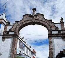
The traditional entrance to the historic center of the town is a colonial era arch, which was built in 1731 and located on the southeast corner of the main plaza next to the municipal palace. It contains a medallion with an image of Christ as the “Humilladero” (humbled), which colonial travelers worshipped. The arch is made of sandstone in Baroque style with geometric fretwork. At the very top is a small column on which used to sit a statue of San Sebastian de Aparcicio. In the 1970s, a bus hit the arch and toppled the statue, which was never replaced.[2][10]
The main plaza has a 1950s era kiosk and contains two small stores in its base selling regional candies. The upper portion has a jukebox. The plaza also contains monuments to Miguel Hidalgo y Costilla and Benito Juárez as well as a ring from a Mesoamerican ball court of the 13th century. The pavement of the plaza was replaced in 1999 from paving stone to patterned concrete. In 2003, a hemicycle dedicated to Benito Juárez was added. While it is considered to be a park, the plaza is often filled with stands on market days and during festivals, but most cultural events take place at the esplanade of the municipal palace. The green areas of the plaza contain sculptures of lions made of iron, but unlike real lions, these are shown with nopal plants, with a boa constrictor and other poses and were donated by the former owners of the Hacienda of Chapingo. For this reason the plaza is also called the Jardin de Leones (Lion Garden).[11]

Facing the plaza on the east side is the Parish of the Asunción, which was originally a Dominican monastery, founded in 1553. The main portal is made of pink stone and still in good condition. This architectural style is very austere.[2] On the facade of La Asuncion there is only sculpture of the Virgin Mary with the faces of angels at her feet and a window cornice, which has decorations in the form of raindrops. Inside, the main altar is Neoclassical. One of the side altars is Baroque with Biblical images surrounded by Solomonic columns. The sacristy has two altars, another Baroque one with Solomonic columns and one dedicated to the Señor del Sacromonte.[7] The most noteworthy painting here is “The Angel of the Annuniciation” done by Echave Orio. The two story cloister is one of the most primitive in the Americas and has four segmental arches resting on octagonal columns on each side.[6] There are two other important chapels in the town; the Chapel of San Juan and the Chapel of the Virgen del Rosario which have functioned as points of reference for travelers since they were built. They were built for the common people of adobe and wood.[2]
Also near the main plaza is the municipal market, which is a traditional place to enjoy local culinary specialties. It contains central Mexican staples such carnitas and barbacoa, but the local signature dish is rabbit. Rabbit is a signature dish of the region. It is prepared as mixote, in moles, wrapped in corn husks and steamed, or simply covered in chili pepper and roasted. Like in other parts of Mexico, atole is popular here but there is a variation seasoned with chili pepper and epazote.[2][8] The municipal market offers dishes and products made from local nuts such a walnuts such as chiles en nogada, chicken in a nut sauce, mixiotes with rabbit and nuts as well as a walnut liquor.[7] In front of this market is a crafts market which sells clay items, photographs of the volcanos, local breads and turnovers filled with apple or pineapple.[8] The market also sells a liquor from walnuts year round but it is especially during the annual Walnut Festival, which takes place in August. This permanent market is supplemented by the tianguis, or traditional outdoor market, held each Sunday. On this day, traders and craftsmen come from as far as Puebla to sell.[6] The town has one pulqueria which serves the pulque straight or flavored. Common flavors such as strawberry, mango, guava and nut are available, but the owner also has original recipes for flavors such as tomato, celery, carrot and others which the owner says are "secret.” .[2]
The state university of UAEM (Universidad Autónoma del Estado de Mexico) has a local campus here.[12]
A major charity is the Cottolengo Mexicano, which is a project of the Obra Don Orione religious foundation. This group was founded in Italy in 1905 and has expanded to over thirty countries to offer charity, education and evangelization. The group established itself here and in Ciudad Nezahualcoyotl in the mid 1990s. The Cottolengo serves homeless children and those who are disabled.[13]
Carnival and Señor del Sacromonte

Just southwest of the parish church is a hill called Sacromonte, which overlooks the town and provides clear views of the Iztaccíhuatl and Popocatépetl volcanos. (There is a lookout tower here used when Popocatépetl is more active.[7] This hill has been considered sacred since the pre-Hispanic period, when a god named Tezcatlipoca was worshiped here with dances and ceremonies from 23 April to 12 May. These days were known as “Toxcatl” or “dry things” as these days usually were the end of the dry season just before the rainy season. An image of the deity was located in a cave at the top of the hill.[1] Today, the hill contains the Sanctuary of the Señor del Sacromonte and a chapel dedicated to the Virgin of Guadalupe.[7]
After the Conquest, the Spanish destroyed the temples and shrines here and build Christian churches and shrines on top of them. The churches located on this hill are a result of that tradition. The first Franciscan evangelist here, Martin de Valencia had the pagan idol replaced with an image of a Black Christ within the cave in the 1540s. Since 1584, this image has been the object of much veneration in this area, especially during the week of Ash Wednesday, which is the closest Christian celebration to the old one for Tezcatlipoca. Hence the worship of this figure is a syncretism which can be best seen during the week of Ash Wednesday when many clad in Aztec dress dance and perform ancient rituals in front of the parish church below and the sanctuary church on the hill.[1]
The Sanctuary of the Señor del Sacromonte is as important as the parish church that is located in the town center below.[1] The Sanctuary was built among the ruins of the teocallis and amoxcallis that there here. The church is considered to be one of the most important in the state.[7] The main focus of the church sanctuary is the glass coffin containing the Señor, which is also called the Santo Entierro (Holy Burial) .[1] The image of the Señor is made with “pasta de cana” or pasted corn stalks.[6] The altar on which it rests is made of wood and gilded with capricious forms.[1]
The old chapel of the Virgin of Guadalupe is situation at the very top of the Sacromonte. It has a smooth facade with three arches and a triangular pediment. Inside there are no altarpieces. The atrium area is an old untended graveyard.[7]

The main celebrations of the town are Carnival and the Feast of the Señor del Sacromonte, which overlap each other. Carnival begins on the Thursday before Ash Wednesday with the traditional accompaniments such as food, amusement rides, local dances such as Los Doce Pares de Francia, Moros y Cristianos and Los Arrieros.[2] However, most of these end on the following Monday, rather than on Tuesday. On Tuesday night, the Señor del Sacromonte is taken from his sanctuary in procession to the parish of La Asuncion in the center of Amecameca. He remains there until Easter Sunday. One last vestige of Carnival takes place on Ash Wednesday, when the Dance of the Chinelos is performed. People costumed in large turbans, robes and bearded masks, perform just after midday.[4] After that point, the celebrations for the rest of the week are focused on the Señor del Sacromonte with masses, pilgrimages and a dance called the Azteca-Chichimeca which dates back to the Conquest. The best-known group to perform this dances under the banner of the Señor del Sacromonte and visits many local and national religious festivities in places like Chalma, the Basilica of Guadalupe and others.[2] Pilgrimages are made to both the La Asunción Church and to the Sanctuary on the hill above. Tradition states that first time visitors to the Sanctuary place a crown of flowers on their heads.[8]
Municipality
As municipal seat, the town of Amecameca is the local governing authority for more than 130 other named communities,[14] which over an area of 181.72km2.[2] The municipality borders the municipalities of Tlalmanalco, Atlautla, Ozumba, Ayapango and Juchitepec with the state of Puebla to the east. 181.72km2.[2] About 65% of the municipality’s population lives in the town proper.[14] At the end of the 19th century, about 85% of the population spoke Nahuatl, but today less than 200 speakers remain.[2]
The municipality is situated on the foothills of the Sierra Nevada between the Iztaccíhuatl and Popocatépetl and in the Moctezuma-Panuco River.[2] The Sierra Nevada is the most important geographical feature of the region and forms the eastern border of the municipality. These volcanoes are responsible for the compositions of the soils here as well as the source of most of the municipality’s fresh water. The average altitude in these mountains is 4,000 meters above sea level with the highest elevations at the Iztaccíhuatl and Popocatépetl volcanos.[2] Although near the active volcano, Amecameca is considered to be at a lower risk than other communities in the area because of the shape of Popocatépetl’s cone and the large ravines that are found in this area. The latter offers protection against lava flows and runoff from melting snow. However, the area remains part of the evacuation zone in the event of a major eruption. There is a lookout station on Sacromonte hill which is used by civil defense when the volcano is more active.[15] The area has an eruption warning system of three colors—red, yellow and green—which depend on the status of Popocatepetl. Green means that the volcano is quiet, yellow that there is activity and caution is advised and red indicates a current or imminent eruption. When the status turns to yellow, tourism to the area plummets to about half normal.[3]
Fully within the municipality, the most important elevation is the Sacromonte. The main river there is the Alcalican, which forms from the snowmelt of Iztaccihualt. Its name means “in the house of water”. Most of the other streams and springs of the municipality are fed by the Sierra Nevada mountains. The climate is temperate and somewhat wet (cb(w2)) with most rains coming between May and October. Temperatures generally vary between 2 °C and 24 °C although temperatures of -8C and 34C are not uncommon.[2]
This area, especially in the rainy season, has an abundance of wild edible plants, especially mushrooms. Undeveloped areas in the lower mountains areas are mostly covered by forests of pine, oak and cypress, with trees reaching over 30 meters in height. However, deforestation is an issue both for the loss of trees and the remaining forests’ ability to resist fires and plagues, with about twenty percent of forested area lost in last decades of the 20th century. Grazing cattle often inhibits reforestation. Higher up, the forests are dominated by fir trees with some pines and cedars. At the highest elevations near the tree line, only one species of pine is found, Pinus hartwagii. Above the tree line are alpine meadows. Small mammals, especially rabbits are common here as a number of reptiles and a variety of birds. The area used to have larger species such as white-tailed deer but these have been hunted to extinction.[2]
Most of the municipality now is dedicated to agriculture and livestock. The main crop is corn along with other grains such as alfalfa, wheat and oats. There are a significant number of orchards here producing walnuts, pears, apples, capulins and other fruit. The municipality is the major producer of walnuts in Mexico. Livestock raised here includes pigs, cattle, sheep and domestic fowl.[2] One important agricultural activity there is the production and conservation of traditional varieties of corn. Like other communities in the area, there are three main varieties of corn planted where as well as a number of minor varieties. These are planted mostly as a trial or because of their special characteristics, not to compete with the three main varieties. In local markets, these farmers are able to sell these local varieties as well as exchange seed to maintain genetic variety.[16]
There is some industry there, which employs about a third of the workforce. The main ones are Los Molinos de la Covadonga, La Harinera Amecameca, Hilos Cadena, which produced milled products and thread. In addition, there are small workshops which produce saddles, ironwork and machine pieces. Most commerce occurs in the municipal seat, mostly with the sale of staple foods and other basic necessities. Market days are Monday, Wednesday and Sunday when the town is covered in portable stalls in a tradition called the tianguis. In addition, there are several hotels and other businesses that cater to tourists. This sector of the economy employ about 45% of the municipality’s population.[2]

Outside of the town proper, there are a number of other tourist attractions in the municipality. There is one registered archeological site in the municipality called the Piedra del Conejo ("Rabbit Stone") or Monumental solsticial de Tomacoco ("Solstice monument of Tomacoco").[2] One of the major attractions is the Panoaya Hacienda. The main hacienda building houses the Sor Juana Inés de la Cruz Museum; it is featured in the reverse of the $200 pesos Mexican note. Sor Juana come to live at Panoaya in 1651 when she was three years old to live with her mother and grandfather. She learned to read and write and stayed until she was sent to live in Mexico City in 1663. The hacienda lay in ruins for the last century or so until it was rehabilitated in 1999 at a cost of more than 10 million pesos. A building next to this one is the International Museum of Volcanos which exhibits of Mexico two most famous volcanoes and others in the world. The hacienda’s main building now serves as the Sor Juana Inés de la Cruz Museum, run by INAH. Much of the rest of the hacienda land is leased to a recreational park which is best known for its petting zoo which contains tame deer.[17]
Another major attraction is the Bosque de Arboles de Navidad (Christmas Tree Forest), one of the few places in Mexico where one can go and cut his/her own tree. The Bosque plants trees such as the “vikingo mexiquense” and the “vikingo canadiense” coming here has become a tradition for many families in the Mexico City area. It is a business that was conceived forty years ago as a way to help preserve the forest here as well as benefit economically. Visitors come to spend a day in the area and can cut trees only from designated locations. Picnicking is permitted with the requirement that no garbage is left behind. The Christmas tree area covers 300 acres (120 hectares), and cut trees are left to regrow instead of being killed. The park also hosts food stalls and a Christmas market, selling about 30,000 trees per year and employing 50 permanent and 250 seasonal workers.The money earned from the enterprise helps to preserve more wild areas of the mountains here. This work has earned a Premio Nacional de Ecología (National Ecology Prize). The only problem the forest experiences is that the enterprise is so popular that the roads leading to the area are jammed with traffic.[17][18]
Lesser-known attractions include the Eco Parque San Pedro, the Temazcal Park and the Agua Viva monastery. The Eco Parque San Pedro (San Pedro Ecological Park) is located between the Amecameca and Nexpayantla rivers just outside the municipal seat in the community of San Pedro Nexapa. It stands at 2870 meters above sea level, very close to the Puebla state line and has a cold, wet climate. The park is between the Popocatépetl and Iztaccíhuatl volcanos near the Cortés Pass. The park was created as a way to manage and preserve the natural resources of the area. It is a recreational area for sports such as hiking and also contains the second largest labyrinth of its type in the world created with over 38,000 cedar trees over an extension of 10,000m2. There is also a “zoo” of sculpted plants made to form animals using plants native to the area.[19] The Temazcal Park is a natural area with dirt and stone paths. It contains a varieity of pine trees and medicinal plants and is home to white tailed deer, foxes and other wildlife. Activities available here are hiking, mountain biking, camping and other nature sports.[20] The Agua Viva (Living Water) monastery is a Dominican institution located at the foothills of Iztaccíhuatl. There are still monks here that offer mass. The Cortés Pass is located 30 minutes from the town, which is a space between the two volcanoes and from where Cortés had his first view of the Valley of Mexico.[8]
Notable residents
- Laura Mendez (1853 – 1928), feminist, writer, poet and educator
References
- 1 2 3 4 5 6 7 "Santuario del Señor de Sacromonte" [Sanctuary of the Lord of Sacromonte] (in Spanish). Amecameca, Mexico: Municipality of Amecameca. Retrieved 2010-03-01.
- 1 2 3 4 5 6 7 8 9 10 11 12 13 14 15 16 17 18 19 20 21 22 23 24 25 26 27 "Enciclopedia de los Municipios de México Estado de Mexico Amecameca" (in Spanish). Mexico: INAFED. Retrieved March 1, 2010.
- 1 2 3 Ambriz, Rodolfo (1997-05-20). "Se desploma actividad turistica en Amecameca" [Tourist activity plummets in Amecameca]. Reforma (in Spanish). Mexico City. p. 3.
- 1 2 Millan, Daniel (1998-02-26). "Animan con Chinelos" [Animated with Chinelos]. Reforma (in Spanish). Mexico City. p. 5.
- ↑ Lopez, Horacio (1999). Amecameca. México: Gobierno del Estado de México.
- 1 2 3 4 Novo, Gerardo; Jorge de la Luz (2002). The State of Mexico. Madrid: Ediciones Nueva Guia SA de CV. pp. 150–151. ISBN 968-5437-26-2.
- 1 2 3 4 5 6 7 8 Quintanar Hinojosa, Beatriz, ed. (2008). "Pueblos con Encanto del Bicentenario" [Towns with Charm of the Bicentennial]. Mexico Desconocido (in Spanish). Mexico City: Grupo Editorial Impresiones Aéreas: 94–97. ISSN 1870-9419.
- 1 2 3 4 5 6 Diaz, Cesar (1999-05-27). "Vamonos de Paseo/ Amecameca: Tradicion al pie de volcanes" [Lets Wander/Amecameca: Tradition at the foot of the volcanoes]. Reforma (in Spanish). Mexico City. p. 12.
- ↑ Garcia, Karol; Inti Vargas (2004-10-21). "Suspende INAH Wal-Mart en Amecameca" [INAH suspends Wal Mart in Amecameca]. Reforma (in Spanish). Mexico City. p. 4.
- ↑ "Arco de San Sebastián de Aparcicio o Arco de Humilladero" [Arch of San Sebastian de Aparcicio or the Arch of the Humbled] (in Spanish). Amecameca, Mexico: Municipality of Amecameca. Retrieved 2010-03-01.
- ↑ "Plaza Principal o Jardín de los Leones" [Main Plaza or Garden of the Lions] (in Spanish). Amecameca, Mexico: Municipality of Amecameca. Retrieved 2010-03-01.
- ↑ "Unidades" (in Spanish). Toluca, Mexico: UAEM. Archived from the original on 6 April 2010. Retrieved 2010-03-01.
- ↑ Torres, Heidy (2003-05-14). "Promete sacerdote musica sin censura" [Priest promotes music without censorship]. Reforma (in Spanish). Mexico City. p. 22.
- 1 2 "INEGI Census 2005" (in Spanish). Archived from the original on 2010-01-18. Retrieved 2010-03-01.
- ↑ Ambriz, Rodolfo (1997-05-16). "Amecameca: Los 'alocan' las noticias" [Amecameca, the news makes them reckless]. Reforma (in Spanish). Mexico City. p. 7.
- ↑ Perales Rivera, Hugo Rafael (1998). ) Conservation and evolution of maize in the Amecameca and Cuautla Valleys of Mexico (Doctorate thesis). University of California, Davis. Docket AAT 9900101.
- 1 2 Romo Cedano, Luis (2001-12-02). "En Amecameca: Bosques, venados y volcanes" [In Amecameca: Forests, deer and volcanos]. Reforma (in Spanish). Mexico City. p. 6.
- ↑ Romo Cedano, Luis (2004-11-21). "En busca del arbol ideal" [In search of the ideal tree]. Reforma (in Spanish). Mexico City. p. 27.
- ↑ "Eco Parque San Pedro" [San Pedro Ecological Park] (in Spanish). Amecameca, Mexico: Municipality of Amecameca. Retrieved 2010-03-01.
- ↑ "Unidad de Manejo Ambiental Temazcal(UMA)" [Unit of Environmental Management of Temazcal (UMA)] (in Spanish). Amecameca, Mexico: Municipality of Amecameca. Retrieved 2010-03-01.
According to the Internet Movie Data Base (IMDB) there were seven movies shot in this area. The movies were 7th Cavalry (1956), Deep Crimson (1996), El libro de piedra (1969), Las vueltas del citrillo (2006), Hermanos de sangre (1974), Secuestro salvaje (1994), Sor Juana Ines de la Cruz entre el cielo y la razón(1996 )[1]
External links
| Wikivoyage has a travel guide for Amecameca. |
| Wikimedia Commons has media related to Amecameca Municipality. |
- Amecameca Municipality Official Site
- Instituto Nacional Para el Federalismo y Desarrollo Municipal
- Christmas Trees Forest
- Promotional video
Coordinates: 19°07′N 98°46′W / 19.117°N 98.767°W

- ↑ IMDB