Ambala Cantonment
| Ambala Cantonment अम्बाला छावनी | |
|---|---|
| City | |
|
Grand Trunk Road, at Ambala Cantonment, during British Raj | |
| Nickname(s): अम्बाला छावनी | |
 Ambala Cantonment  Ambala Cantonment Location in Haryana, India | |
| Coordinates: 30°21′43″N 76°50′53″E / 30.361915°N 76.8480778°ECoordinates: 30°21′43″N 76°50′53″E / 30.361915°N 76.8480778°E | |
| Country |
|
| State | Haryana |
| District | Ambala |
| Government | |
| • Body | Cantonment Board Ambala |
| Population (2011) | |
| • Total | 55,370[1] |
| Languages | |
| • Official |
Hindi English Punjabi |
| Time zone | IST (UTC+5:30) |
| Vehicle registration | HR 01, HR 37 |
| Website |
haryana |

Ambala Cantonment (Hindi:अम्बाला छावनी) is a cantonment town in Ambala district in the state of Haryana, India. It is some 200 kilometres north of Delhi and 55 km south from Chandigarh. Delhi-Kalka & Saharanpur-Ludhiana's railway lines and G.T. Road also passes through Ambala Cantt. This Cantt. was established in the year 1843 and is an important centre for manufacturing of scientific & surgical instruments. It is also called the science city due to huge exports of scientific instruments [2]
Overview
_Malwa_Express_at_Ambala_Cantonment_station.jpg)
The Cantonment is from the British times as it lies at an important junction, from here one can take the road North to Chandigarh and onwards to Simla, or turn East towards Uttar Pradesh, or go west to Ludhiana, and onwards to Jalandhar and Amritsar - Lahore.
Ambala Cantonment railway station
It is a prominent junction and is located on the Grand Trunk Road. Just across the railway station is the bus stand. It is the main terminal that connects all railway stations from south ,east,west,north.
British Raj
It has a lot of colonial bungalows and wide tree lined roads typical of British Cantonements in the subcontinent. It also gets a mention in the Rudyard Kipling book Kim. The formation sign of Punjab, Haryana and Himachal Pradesh Area (earlier Punjab Area) located here (a Taurus on a Red background) is a theme in the book. The formation sign still exists for an Indian Army formation in Shimla with some units affiliated to it still using the sign in Ambala.
European Cemetery
Historic Ambala European Cemetery is located here.
Indian Army & Airforce Base
.jpg)
It is currently the Headquarters of II Corps (India),(raised in 1970, formation sign Kharga) and an important forward Indian Air Force base .It played an important role during 1965 and 1971 war between India and Pakistan
Demographics
As of 2011 India census,[3] Ambala Cantonment had a population of 55,370,. Males constitute 61% of the population and females 39%. Ambala Cantonment has an average literacy rate of 91.24%, higher than the national average of 59.5%; with 95.07% of the males and 85.32% of females literate. 11.41% of the population is under 6 years of age.
Visitor attractions
- Gurudwara Lakhnaur Sahib
- Gurudwara manji sahib
- Gurudwara panjokhra sahib
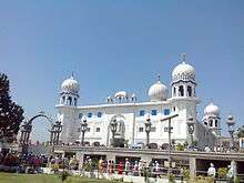 Gurudwara Panjokhra Sahib, Haryana
 - Hathi Khana Shiv Mandir
 a temple in ambala cantt
 - ST. Thomas Orthodox Syrian Church
- Holy Redeemer Church
- Saint Paul’s Church
- Indira Park
- Christian Cemetery
- Raja Ka Talab
- Rani Ka Talab
- Kharga Golf Club
Education
Many colleges have now been established in the area for higher education from last few decades. It mainly includes Engineering Colleges which are affiliated to Kurukshetra University, Kurukshetra.[4] Moreover, some Historic Colleges which were established before independence of India are also present, an example of that is Sanatan Dharma College on Ambala–Jagadhri Highway established in 1916 in Lahore.Kendriya vidyalayas,Army public school,DAV public schools etc. are among the best schools for the locals.
See also
References
- ↑
- ↑ For the above info, http://www.ambalayellowpages.com/about.html
- ↑ "Census of India". Census Commission of India. Retrieved 2015-09-21.
- ↑ List of Engineering Colleges affiliated to Kurukshetra University, Kurukshetra
-
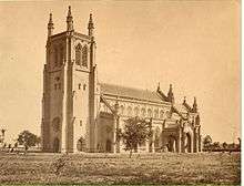 Saint paul church before damaged by the missileAmbala district topics
Cities and towns 
Transport Lok Sabha constituencies