Amami Islands
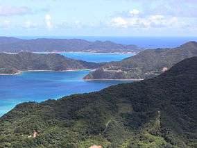 Coast of Amami Oshima | |
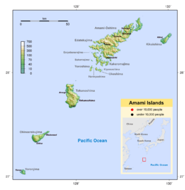 Map of the Amami Islands | |
| Geography | |
|---|---|
| Coordinates | 28°16′N 129°21′E / 28.267°N 129.350°E |
| Adjacent bodies of water | Pacific Ocean |
| Total islands | 8 (inhabited) |
| Highest elevation | 694 m (2,277 ft) |
| Highest point | Yuwandake |
| Administration | |
|
Japan | |
| Prefectures | Kagoshima |
| Demographics | |
| Population | 121,266 (2008) |
| Ethnic groups | Ryukyuan, Japanese |
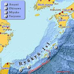
The Amami Islands (奄美群島 Amami-guntō)[1] is an archipelago in the Satsunan Islands, which is in turn part of the Ryukyu Archipelago. Administratively, the group belongs to Kagoshima Prefecture, Japan. The Geospatial Information Authority of Japan and the Japan Coast Guard agreed on February 15, 2010, to use the name of Amami-guntō (奄美群島?) for the Amami Islands. Prior to that, Amami-shotō (奄美諸島?) was also used.[2] The name of Amami is probably cognate with Amamikyu (阿摩美久) or Amamiko (アマミコ), the goddess of creation in the Ryukyuan creation myth.
Geography
The Amami Islands are limestone islands of coralline origin and have a total area of approximately 1,240.28 square kilometres (478.87 sq mi). The highest elevation is Yuwandake with a height of 694 metres (2,277 ft) on Amami Ōshima. The climate is a humid subtropical climate (Köppen climate classification Cfa) with very warm summers and mild winters. Precipitation is high throughout the year, but is highest in the months of May, June and September. The area is subject to frequent typhoons.
History
Amami period
Islanders started to produce earthenware from 6000 years ago, affected by the Jōmon culture in Kyūshū. Initially, the styles were similar to those of the main islands of Japan, but later, a style original to Amami, known as “Usuki Lower Style”, was developed.
Among Japanese literature, mention of the islands first appeared in the 7th century. The Nihon Shoki contains an entry dated 657 referring to Amami-shima (海見嶋, "Amami Island"), and to the Amami-bito (阿麻弥人, "Amami people") in 682. The Shoku Nihongi refers to Amami (菴美) in 699 and Amami (奄美) in 714. All of these are believed to be identical to the current Amami. The tenth kentō-shi mission (Japanese Imperial embassies to China) traveled to Tang Dynasty China via Amami Ōshima.
Among locals, this prehistoric period is called Amami period (奄美世 Aman'yu).
Aji period
Agriculture came to the islands around the 12th century, and the people shifted to farming from hunting. As in Okinawa, this resulted in the development of a gentry class called the aji, who resided in castles called gusuku. Famous gusuku included Beru Gusuku in Kasari, Amami, and Yononushi Gusuku in Wadomari. Stronger aji battled each other to expand their territories. Local folklore states that some of Taira clan members, having lost the Battle of Dan-no-ura in 1185, fled to Amami Ōshima. The historical accuracy of this is unknown.
This gusuku period is sometimes called the Aji period (按司世 Ajin'yu).
Naha period
Eventually the Amami aji were forced to pay tributes to stronger nations around to retain autonomy. Okinawan records state that Amami aji paid tribute to Eiso, the king of Chūzan in Sanzan period Okinawa. Okinoerabujima and Yoronjima went under Hokuzan's control. However, since Okinawa itself was still unsettled with civil wars, it could not control the northern part of Amami Islands. Tokunoshima and further north island aji just paid tributes to Okinawa, and continued to remain independent. After 1429, Shō Hashi unified Okinawa Island, founding the Ryukyu Kingdom. Okinoerabujima and further south islands were directly controlled by Ryūkyū, while northern parts were also treated as the outer territories of the kingdom. The fourth king, Shō Sei, tried to occupy Amami Ōshima in 1537, but failed. The next king, Shō Gen, won a battle in 1571, which brought the entire group of islands under Ryūkyū control. According to folklore, three gusuku and four communities fiercely resisted the invasion, and were all eliminated.
This period is called Naha period (那覇世 Nahan'yu), after the major port of Ryūkyū.
Edo period
Ryukyu's direct control didn't last long. Trade with Ming Dynasty China, which flourished in the Azuchi-Momoyama period, led Shimazu Tadatsune, the ruler of Satsuma Domain in southern Kyushu, to invade the Ryukyu Kingdom in order to gain control of the shipping routes between Japan and China. In March 1609, Shimazu launched an invasion of Amami Ōshima, then Tokunoshima, Okinoerabujima, and Okinawa itself. The Shimazu quickly defeated the Ryukyu Kingdom, and Shimazu control over the islands was formally recognized by the Tokugawa shogunate.
The Ryūkyū Kingdom was troubled by the Amami Islands even before the invasion by Satsuma, as the islanders often demonstrated independence movements from the kingdom. Ryūkyū ceded the islands to the Satsuma Domain. Satsuma started to directly rule the islands from 1613, sending a commissioner. However, it was still nominally treated as Ryūkyū territory, and bureaucrats from the kingdom were dispatched as well.
At first, Satsuma's administration was a mild one, but as the financial deterioration of the domain became worse, the administration changed to one of exploitation. Satsuma imposed high taxes payable in sugar. This resulted in sugarcane monoculture, which often resulted in severe famines.
During these times, the Amami people found their joys in local liquors made from sugarcanes, awamori bought from Ryukyu, and folk songs sung with sanshin. Their folk songs evolved into a style different from that of Ryukyu, and still remain as a part of their culture today. Under Satsuma's rule, names of Amami people underwent a great change, and they are today known for many unique one-character surnames.
In 1879, after the Meiji Restoration, the Amami Islands were incorporated into Ōsumi Province, and then into Kagoshima Prefecture. During World War II, more than 20,000 Japanese soldiers garrisoned the neighboring Amami Islands, although the islands were never invaded, and experienced only small scale airstrikes.
This period, until 1945, is called Yamato period (大和世 Yamaton'yu), after Yamato, the Amami exonym for mainland Japanese.
American period
After the surrender of Japan, the Amami islands went under direct American military control, with American documents referring to the Amami Islands as the "Northern Ryukyu Islands". The Japanese government believed this indicated an American intention to permanently separate the islands from Japan, and in response, stressed to the American occupation authorities that the islands were an integral part of Kagoshima Prefecture.
In February 1946, the Amami Islands were officially separated from Japan. In October, the Provisional Government of Northern Ryukyu Islands was founded, formed by local leaders. It changed its name to the Amami Gunto Government in 1950. However, under a democratic election, the local electorate chose a governor who pledged restoration to Japan. (This also happened in other Gunto Governments of Ryukyu, namely those of Okinawa, Miyakojima, and Yaeyama.) The United States Civil Administration of the Ryukyu Islands, (USCAR) was alarmed by this development, and reduced the power of Gunto governments to that of a figurehead status. In 1952, USCAR founded another governmental body called the Government of the Ryukyu Islands, in which they could choose "local leaders" by themselves.
Amami residents were dissatisfied with these controls by the U.S. Moreover, the Amami economy suffered from separation from the mainland Japanese market. Public funds of the U.S. administration were mostly used for heavily damaged Okinawa. The Amami Islands Homeland Restoration Movement, which had started immediately after the separation, became stronger. Among locals over 14 years old, 99.8% of them signed in a bid toward restoration. Some municipalities and communities went on a hunger strike after the example of Mahatma Gandhi.
The Treaty of San Francisco in 1952 put the Amami islands under trusteeship as part of the Ryukyu Islands. The U.S. returned the Tokara Islands to Japan in February 1952, and the Amami Islands on December 25, 1953. The U.S. government called it "a Christmas present to Japan".
This period is called the American period (アメリカ世 Amerika-yu).
After the restoration
Although the Amami islands were returned to Japan in 1953, Okinawa remained under American control until 1972. Because of this, Amami people who worked in Okinawa suddenly became "foreigners", making their situations difficult.
The Japanese government promulgated the Amami Islands Promotion and Development Special Measures Law. However, the economic gap between the islands and the mainland still exists to this day. The law did help residents by improving the island's infrastructure. However its bureaucratic system has been criticized as causing unnecessary destruction of nature.
Islands
| Photo | Name | Kanji | Area [km2] | Population | highest point [m] | Peak | Coordinates |
|---|---|---|---|---|---|---|---|
| Amami Ōshima | 奄美大島 | 504.88 | 73,000 | 712.35 | Yuwandake | 28°19′35″N 129°22′29″E / 28.32639°N 129.37472°E | |
| Kikaijima | 喜界島 | 56.93 | 7,657 | 214.0 | 29°19′01″N 129°56′22″E / 29.31694°N 129.93944°E | ||
| Kakeromajima | 加計呂麻島 | 77.39 | 1600 | 314 | 28°07′29″N 129°14′41″E / 28.12472°N 129.24472°E | ||
| |
Yoroshima | 与路島 | 9.35 | 140 | 297 | Okachiyama | 27°22′08″N 128°34′00″E / 27.36889°N 128.56667°E |
| |
Ukejima | 請島 | 13.35 | 200 | 400 | Ōyama | 28°01′38″N 129°14′22″E / 28.02722°N 129.23944°E |
| |
Tokunoshima | 徳之島 | 247.77 | 27,000 | 645 | Inokawadake | 27°49′12″N 128°55′56″E / 27.82000°N 128.93222°E |
| Okinoerabujima | 沖永良部島 | 93.63 | 15,000 | 246.0 | Ōyama | 27°22′08″N 128°34′00″E / 27.36889°N 128.56667°E | |
| |
Yoronjima | 与論島 | 20.8 | 6,000 | 98 | 27°22′08″N 128°34′00″E / 27.36889°N 128.56667°E | |
Culture
As a part of Ryukyu cultural sphere, Amami culture is closer to that of Okinawa Prefecture than to that of mainland Kagoshima. However, the islands' history is different from Okinawa as well. Okinawa, including the Sakishima Islands, had strong cultural influences from China, whereas Amami was affected more by mainland Japan. Because of this, the Amami people themselves regard their culture as distinct from that of Okinawa. The mainland Amami people treat the area between Kikaijima, Amami Ōshima, and Tokunoshima as the part of their own cultural sphere.
On the other hand, islanders from Yoronjima, just 22 km away from mainland Okinawa, have much closer culture ties to Okinawa.
Language
Idiolects spoken in a large part of the Amami Islands are collectively known as the Amami language/dialect. It is divided into several dialects: the Kikai dialect, North Amami dialect, South Amami dialect, and Tokunoshima dialect. Dialects spoken in the southern islands of Okinoerabujima and Yoronjima are closer to those of Kunigami of northern Okinawa, and hence called Okinoerabu-Yoron-Northern Okinawan dialect.
These dialects all belong to the North Ryukyuan group of the Ryukyuan languages. Although the Ryukyuan languages belong to the Japonic family along with Japanese, they are mutually unintelligible.
Just as anywhere else in Japan, standard Japanese is used in all the formal situations. The de facto common speech among locals under 60, on the other hand, is Amami-accented mainland Japanese, locally referred to as Ton-futsūgo (トン普通語, lit. "Potato standard"). The speech is different from Uchinaa-Yamatuguchi (Okinawan Japanese), an Okinawan-accented mainland Japanese used in Okinawa. Ton-futsūgo is affected not only by standard Japanese, but also by the Kagoshima dialect and the Kansai dialect.
Music
The local folk songs in Amami are called shimauta. Although shima means "island" in Japanese, it means "community" in Amami. Thus shimauta literally means "communities' songs". Singers of shimauta are called utasha (lit. "singer"). Some utasha also sing pop songs as well, examples include Chitose Hajime, Kousuke Atari, RIKKI, and Anna Sato. Some believe that the word shimauta originally referred to Amami folk songs only, and is therefore now mistakenly used for Okinawan folk songs. The Japanese rock band The Boom's 1992 hit song called Shima Uta, which incorporated some Okinawan styles and thus causes confusion as to the precision of the term. Others argue the word was used for Okinawan folk songs as well even before 1992.
While Okinawan folk songs use the pentatonic scale of C, Db, Eb, G, Ab, Amami folk songs use the scale of C, D, E, G, A. Singers use a falsetto voice when singing.
Religion
Each community has multiple Shinto shrines, whereas Buddhist temples are less common than in mainland Japan. As in Okinawa, female priests called noro exist, and the people worship according to the local religious norms.
The current tomb style is same as those in mainland Japan, unlike those in Okinawa. However, there are tombs called "Shiroma Tofuru" Tombs, which were built 400 years ago, showing the style of Okinawan tombs before the current “house” style there.
Region
- The regional commercial center is the city of Amami on Amami Ōshima.
- There are no universities or colleges in the Amami Islands. From 2004, The Graduate School of Humanistic-Sociological Sciences of Kagoshima University started satellite schooling in the city of Amami.
- There are repeaters of television and AM radio. Among FM stations, only NHK-FM has a repeater, but there is a local community FM station as well.
- There are two local newspapers in the Amami Islands, namely the Nankainichinichi Shimbun and the Ōshima Shinbun.
See also
- Amami rabbit, a rabbit endemic to Amami Ōshima and Tokunoshima
- Amami woodcock
References
- National Geospatial Intelligence Agency (NGIA). Prostar Sailing Directions 2005 Japan Enroute. Prostar Publications (2005). ISBN 1577856511
- Eldridge, Mark. The Return of the Amami Islands: The Reversion Movement and U.S.-Japan Relations. Levington Books (2004) ISBN 0739107100
- Hellyer. Robert. Defining Engagement: Japan and Global Contexts, 1640-1868. Harvard University Press (2009) ISBN 0674035771
- Turnbull, Stephen. The Most Daring Raid of the Samurai. Rosen Publishing Group (2011) ISBN 978-1-4488-1872-3
- ↑ The name Amami-guntō was standardized on February 15, 2010."『奄美群島』を決定地名に採用". Geospatial Information Agency of Japan. Retrieved 23 November 2011. Prior to that, another name, Amami shotō (奄美諸島), was also used.
- ↑ "『奄美群島』を決定地名に採用". Geospatial Information Agency of Japan. Retrieved 23 November 2011.
External links
| Wikivoyage has a travel guide for Amami Islands. |
| Wikimedia Commons has media related to Amami Oshima. |
- (Japanese) Amaminchu.com
- (Japanese) Nankainichinichi Shimbun
- (Japanese) Central Gakki, Amami folk song distributor
- (Japanese) Amami FM
- Amami Wordlist at the Austronesian Basic Vocabulary Database
- Japan Mint: Commemorative Silver Proof Coin of the 50th Anniversary of the Restoration of the Amami Islands to Japan